CNWR-Sope Creek

Marietta Paper Mill Ruins & More map

Mill Ruins on the Creek
From Sope Creek


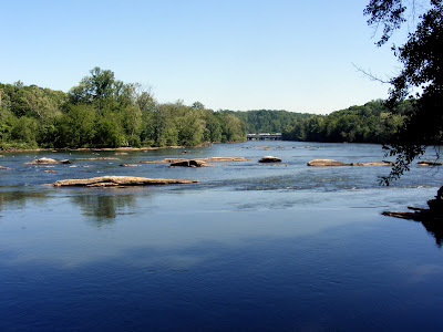
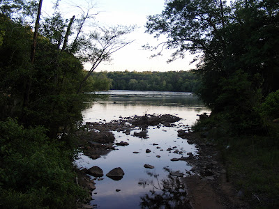
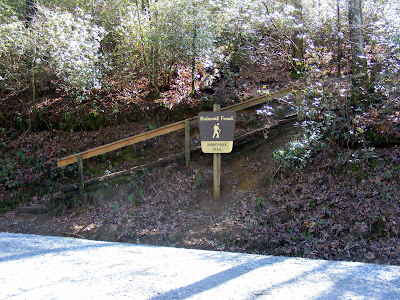
One of the more compelling places among the Chattahoochee River National Wildlife Reserve is the Sope Creek Unit . It may be overlooked to a degree because it does not run along the Chattahoochee River at all. Sope Creek is a small but pretty creek that feeds the river.

Sope Creek

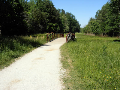
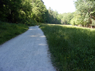
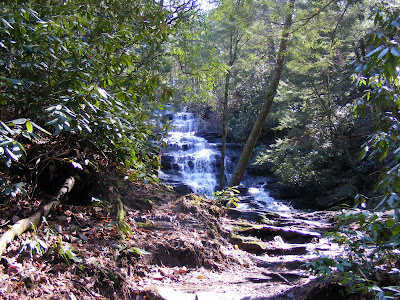
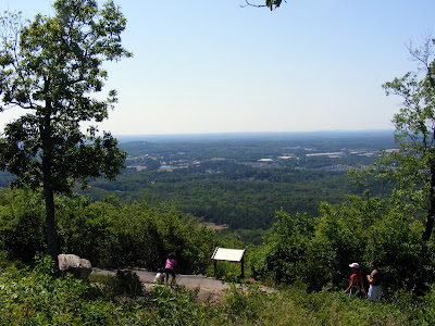
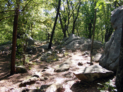
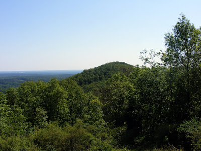
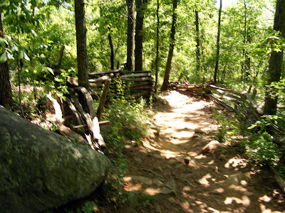
This one is arguably my favorite of all the CNWR units. Even with its proximity it is relatively peaceful and uncrowded. The trails are of varying inclinations to get the heart pumping but nothing overly strenuous. The outer loop runs about 3 miles, but there are several crossing paths that can take you an additional 3 miles easy, and you can follow the river a bit longer than that if you want.

Marietta Paper Mill Ruins

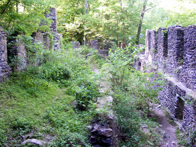
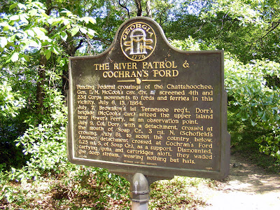
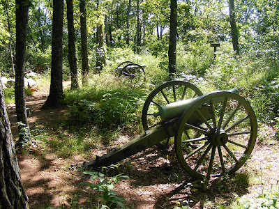
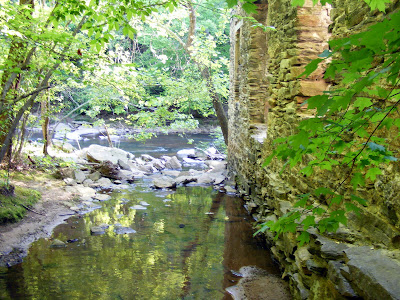
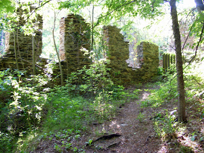
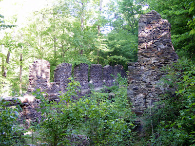
But what I like most about it is the interesting things to see. The centerpiece of the park is the Marietta Paper Mill Ruins . The Mill, built in 1859, was a primary source of paper for the South and rumored to be place Confederate Money was printed (this is unsubstantiated). Garrard‘s Soldiers burnt the mill down on July 5, 1864. It was rebuilt a year later, but suffered serious fire damage again in 1870. Again being rebuilt but closed for good in 1902. The area in its heyday held the paper mill, a flour mill, a twine plant, and a power plant. The ruins are in reasonably good condition, especially compared to other ruins I have seen like Roswell Mill or Skull Shoals. And very pretty covered in plant growth along the rocky creek. Some of the ruins are on the West Side of the Creek, but the larger portion are on the Eastern side, you have to either cross the vehicle bridge or wade across Sope Creek to get to the other side to see the additional pieces

More Ruins

It also has an Indian ties being the residence of an Cherokee man named Sope, for which the creek is purportedly named. Somehow, due to his stature in the community he was allowed to bypass the Cherokee Removal and remain on his land. He is said to be buried in Sewell’s Cemetery.

More Ruins

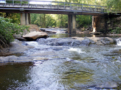
There’s also a covered bridge story here. Cobb County’s second to last covered bridge crossed the road right at the vehicle bridge, but it was burned to the ground in 1964 (Arson Suspected). Only the masonry at the base remains. One can only imagine how much prettier this already beautiful location would have been it the Paper Mill Covered Bridge still survived.

Paper Mill Covered Bridge Masonry

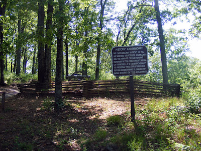
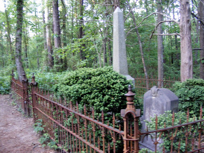
Also if you walk the eastern path away from the ruins toward the Columns Drive parking, you will literally stumble across a small cemetery with three tombstones. The gates are artistically rusted and it appears to be the family of Daniel Scribner M.D. Dr. Scribner died in 1883 and the other two are seriously worn such that I would only be guessing what the names are. (If you know more about this please let me know).

a note on the cemetery after original publication: According to this website here is some additional information about the gravesite, posted by a Charles Andrews in 2004:

Dr. Daniel Dana Scribner married Sarah Jane Ansley, daughter of Marlin and Zeruah Johnston Ansley. Sarah is buried there with her husband, four Scribner children, and my GGG grandmother Mary Winifred Ansley Andrews. Mary Andrews was Sarah's sister. They, both widows, lived together on the Scribner place in their later years until their deaths in the 1880s.
I have Dr. Scribner's medical diploma from the University of Pennsylvania Medical College.
Dr. Scribner's Grave

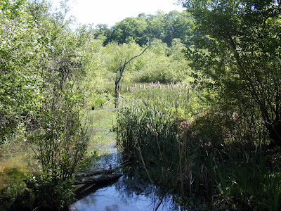
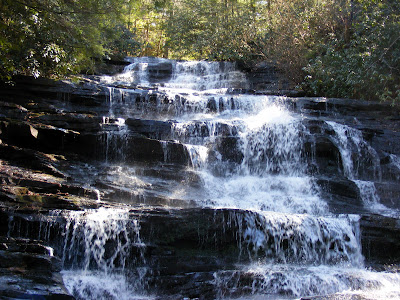
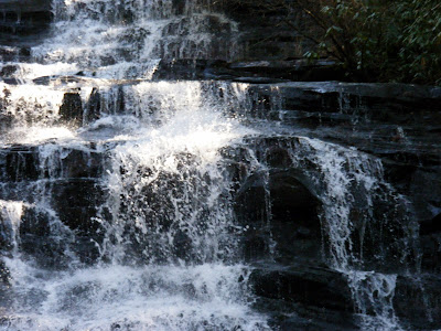
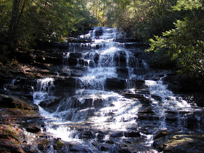
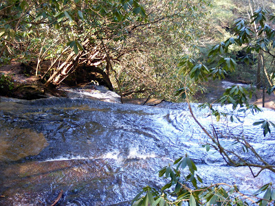
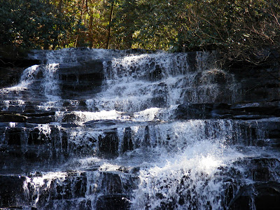
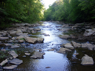
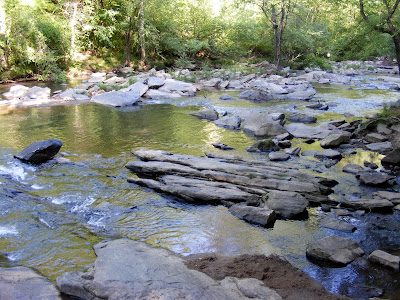
The Creek itself has very pleasant cascades and there a small pond on the West side of the park, both apparently good fishing locations. So if you are looking for a pretty place with relative quiet that anyone can enjoy for a few hours, the Sope Creek Unit is great answer.

Sope Creek Again


Trail Essentials
Approximate Time: 3-4 hours
Approximate Distance: 4-7 miles
Trail Surface: Compact Soil, a short patch on paved road with traffic
Features: Creek, Cascades, Ruins, History

Overall Rating:B+
Scenic Quality: A
Athleticism: B-
Solitude: B
Value: A
Parking: $3
Hours of Operation: daylight hours
Facilities: at the parking area
Maps: Trail Map
County: Cobb

CNWR-Cochran Shoals

A Very Popular Destination
Columns Drive-Map Interstate Parkway-Map

Cochran Shoals
From Cochran Shoals


Now it would be rare for me to say anything negative about a place, or to do anything to discourage anyone from getting off the couch and getting out of the house, so I am going to try to avoid it. But because of high gas prices at its proximity, and someone asking me the question about hiking in the city, I thought I would discuss this particular location.

Ducks on the Hooch

Probably the most popular stretch of the Chattahoochee River National Wildlife Reserve is the Cochran Shoals unit and I simply don’t quite understand its draw. Admittedly, I am a little lacking in my knowledge of nature to be impressed by a rare bird or a rare plant or a rare butterfly, but I think I know something beautiful when I see it. It also has some history to it, with no lasting remnants, being the approximate place Federal Troops crossed the Hooch during the March on Atlanta (a couple of historical markers are present)

Nearby Marshes

Now Cochran Shoals is a pretty place with some nice views of the Chattahoochee, and a portion of it runs through some wetlands that offer plant life that, even if I didn’t know what it was, was intriguing. And It was pretty clear to me that it would be a nice place for a bike trip being relatively flat with paths that are considerably wider than most allowing to pass fellow travelers comfortably. And its very, very near the city with the Interstate Entrance being less than a half mile off 285, and the Columns drive entrance not too much further.

pathway

As best as I can tell the reasons to go there are these:
1. It is very close to Atlanta.
2. Due to the simplicity it is a very easy place to get started in outdoor exercise, no matter what your age or physical condition.
3. Because of the number of people on the trail, it would seem safer than other places, even for groups as small as one. Or you prefer people watching.
4. The Chattahoochee River is majestic and beautiful.
5. You prefer biking to hiking
6. You’re a nature lover and there’s something here I’ve overlooked.

The River between some trees

But what I don’t get is why, especially if you parked at the Columns Drive, why you wouldn’t turn right a head up to Sope Creek (you could do both but you would be looking at about 10 mi round trip). A much more adventurous hike with changes in inclination and some interesting things to see. The second part to the why is given all the options we have in and outside of Atlanta, this place is so darn popular. The last time I went it was 2 pm on a Wednesday and the parking lot was 80% full. There must have been 50 or 60 people on the path. One thing I look for in my hikes is solitude, which could only be found on the less frequently taken nature paths away from the river.

Wide Gravel Path

I’m not saying don’t go there. By all means get out and do something. And if this is your flavor of choice, more power to you. But maybe you could help me understand what makes this one so special.

Historical Marker

Trail Essentials
Approximate Time: 1.5-2 hours
Approximate Distance: basic loop 2 mi, and 3-4 miles of side trails
Trail Surface: Compact Soil, Gravel
Features: Wildlife, River Views, Nature Trails
Overall Rating:
Scenic Quality: B
Athleticism: C-
Solitude: D
Value: B- (primarily due to proximity)
Parking: $3 dollars
Hours of Operation:
Facilities: Portables at both parking areas
Maps: here From Columns Drive , From Insterstate Parkway
County: Cobb

Minnehaha Falls

Chasing Waterfalls--Again map

Minnehaha
From Minnehaha Falls


I thought I might share some nice photos of what the water can look like here in Northern Georgia. To me the saddest thing about hiking in Georgia drought season is the sight of a dried up waterfall. It’s like going to a baseball game and it being rained out. It takes something special and makes it simply go away.

A closer look

So as I was walking down a favorite path along what was once a pleasant little falls and is now simply some dirt (not the site of this pictorial, but at Mulberry Park ), I decided that we needed to see some water, even if its photos from the spring, traditionally the best time for seeking a good water show.

The Falls Full View

These were taken at one of the most memorable falls I have seen in Georgia, at Minnehaha Falls , near Lake Rabun (about 4 miles from Clayton, Georgia) in Rabun County , in Georgia‘s Blue Ridge Mountains . It’s not much of a hike being about .5 miles to the Falls from the parking lot (1 mi round trip). The drive to get there is more of an adventure, driving on a dirt road, passing the venerable Beechwood Inn , and some beautiful homes on Lake Rabun, as well as the lake itself. The parking lot, if you could call it that, is just a small patch of land near the trailhead that can fit a mere handful of cars.

Falls Peeking Through the Trail

But this is a great example of stellar payoff for minimal work. A quick jaunt to see something majestic that you could do in an hour if your in the neighborhood. Waterfalls are best in the Spring, and after rains, and there are many to choose from in the North Georgia mountains. This is a convenient add-on to a trip to Panther Creek or Toccoa or Tallulah Gorge .

At the Top of the Falls

The Falls are a 100 feet high series of 3-5 foot cascades that is my favorite of the lesser known waterfalls. My most frequent traveling companion said the sight of the rushing water simply took her breath away. You walk up a short flight of stairs, then along a path for a quarter mile or so. The Falls then literally jump in front of you.

Another Close Up

When we went, we climbed a little side trail to see the top of the falls, an exhilarating and difficult maneuver since it is a steep incline and must be traversed over parts on hands and knees (and we did it after a nice rain so it was muddy as heck too. I only bring this up to say three things: Its amazing how much of a show a little stream of water can make over some rocks placed just right, it can be done if you put in the effort, and finally, how important it is in life to sometimes actually take the road less traveled rather than simply talk about it.

The Trail head

Among the many Waterfalls of North Georgia that exist, Minnehaha Falls is a picturesque falls less than two hours from Atlanta (about 90 miles), well worth the side trip, especially if the waters are running.

Trail Essentials
Approximate Time: 45-60 minutes (principally viewing time)
Approximate Distance: 1 mile roundtrip
Trail Surface: Short Staircase, compact soil
Features: Stunning Waterfalls, shoals, nice little stream

Overall Rating: B-
Scenic Quality: A
Athleticism: D
Solitude: B
Value: B
Parking: limited and free
Hours of Operation: Daylight hours
Facilities: None
Maps: Not really necessary
County: Rabun County

Jimmy Carter Presidential Library

A Failure or Visionary? map

Jimmy Carter Campaign Poster
From Jimmy Carter ...


I stood inside the Clinton Presidential Library in Little Rock back in April, next to my brother and he asked me if I had ever been to the Jimmy Carter Library. I was ashamed to say no, and sort of half-lied trying to save face. I had driven by it numerous times on my way to get a pizza , but never stopped. He said, “Next time I come to Atlanta, we should go.” It was agreed; it would be so.

the Grounds

Now, why hadn’t I gone. Most people I asked shamefully said no, or lied like me, or said they went on a school trip or something a long time ago. No one proudly said that they went on their own volition, or said they enjoyed it. (I want to change this). I think it’s because we lived through the Carter Presidency and the general consensus adopted with the rise of the Republican Noise Machine was that he was one of the worst presidents ever . But most historical rankings place him in the twenties out of currently 44 (by Historians ,by public opinion). Average maybe, but not awful, unless the U.S. Presidency is a parade of truly horrible men.

hostage crisis display

I want to change this disposition. I went and I was moved. Compared to Clinton’s palatial library, the building and its contents were simple. But, it appeared even-handed and I was impressed by its real attempt to frame Jimmy Carter’s service to the country within a historical context.

Middle East Peace display

There are displays discussing the negatives we remember vividly. Most notably the Hostage Crisis and the Fuel Crisis . They were treated fairly without real attempt at apologetics. His principal success, Peace between Egypt and Israel was given no grander treatment. I found this humility admirable. There were displays of some of the gifts he received, most interestingly portrait done by Mexican Artist Octavio Ocampo.. There was the replica of the Oval Office and the famous Resolute desk (as in National Treasure 2). I heard a rumor that you could sit in the desk and get a photo, but that was not the case. (My brother and I thought that they may have stopped this practice because of the fun-loving boyfriend and girlfriend opting to strike a Clintonesque pose). There were taped interviews and you could watch two of the famous School House Rock! videos (Energy & How a Bill becomes a Law). There was a nice 15 minute film of the presidency to set the stage correctly.

Oval Office & Resolute Desk

But struck by the broader picture, I formulated a different picture of the man. His principle undertakings, Human Rights, Education, Stagflation in the Economy, Middle East Peace, and Energy, resonated in my head with the issues of the 21st Century. Darfur, Ethiopia, Afghanistan, China are human rights issues of the day. Education has become worse and worse. We face, whether we like to call it or not, a real recession. Our demons are legion in the Middle East. And our Fuel crisis is double anything we faced in the 70’s. Carter’s speeches on turning toward fuel conservation became a subject of jokes and ridicule. He elevated Energy to a Cabinet level position (Do you even know who Samuel Bodman is?).

Ocampo's Portrait

Carter created the Department of Education. Carter appointed Paul Volcker as the Federal Chairman, who was the architect of the monetary reforms that hurt, but cured Stagflation issues (Greenspan & Bernacke are unfit to hold his Volcker’s jockstrap--it’s like replacing Dan Marino with Jay Fielder). The Camp David Accords saw the first recognition of Israel by an Muslim country, real peace across religious barriers. Carter's energy policy of conservation is going to be our forced mantra looking at our $4+ a gallon gas prices and $150+ per barrel oil prices.

Carter's Place in History

So what happened to our National Direction. Our course change drastically with the Election of Ronald Reagan . Reagan decreased funding to the newly formed Department of Education. He focused globally (and successfully) away from the Middle East. He symbolically removed the solar panels from the White House (What harm could the solar panels cause?), to highlight our shift from a saving to a wasting nation. I stood in the library, for the first time of my life, thinking how much different we could have been if we had re-elected Carter instead of bringing in Reagan. Maybe Carter wasn’t the failure, our short attention to history remembers. Considering the world we live in, maybe, just maybe he was a visionary, an prophet disliked and ignored in his own country. And regardless of your agreement or disagreement with this, he is our native son, our only Georgia-born President.

Entering the Library

So I want this post to serve two purposes. First, I want the general public to reexamine the Jimmy Carter Library as a possible destination in your wanderings. The cost is $8 for adults, but kids 16 and under enter free (June 2008). And secondly, I wanted this to be a public apology to Jimmy Carter for every bad thing I ever said about him. No, you weren’t perfect, but you were trying and you were right. I formed an opinion about you when I was Eight that it took me decades to shake:

President Carter, if you ever read this, I am sorry, truly sorry.

Kennesaw Mountain

The Crescendo of Johnston & Sherman’s Macabre Dance map

Cannon atop Kennesaw Mountain
From Kennesaw Moun...


I’ve put this one off for way to long. And for that I apologize. It is truly one of the finest hikes in Area. When I first thought about classifying the hikes I have taken, I first formulated a more objective criteria, trying to give each hike a numeric value based on select criteria: Physical Challenge, Historical Significance, Natural Wonder, Cost, Solitude, & Proximity. And every time I ran the numbers this particular hike came up number 1. The catch to me was subjectively I thought a couple of hikes were better than it. (Now realize, only a couple of hikes are better than it, primarily due to the magnitude of the Natural Wonder the other hikes bring with it, remember I like to photograph cool stuff).

a viewing platform

But this one has got all of those things with some extra to burn. I actually recommend that you take two days on this path. One for the front half and one for the back half (there are actually 18 miles of trails here).

Historic Earthworks

So who is this technical #1 in my book. I give you the majestic trail system at Kennesaw Mountain National Battlefield Park [Complete Park Map, Trail Map]. It’s a short drive out of town to Marietta. There’s no parking fee, so go as often as you like. The hike from the welcome center to the viewing platform is a little more than a mile with an elevation gain of around 700 feet. The view from the top of the mountain gives excellent panoramic views of the area, including nice views of Atlanta and the King and Queen Buildings in Sandy Springs. It’s a little better in the winter when the leaves are gone from the trees (I‘ve spent the past two Christmas days on this mountain--it is open), but there’s two or three good viewing places regardless of time of year. The only drawback to the trail is that the first section (from the Center to the main viewing platform) can be a little crowded, however if you continue past the platform, tranquility is normally yours.

view of Atlanta

And the Historical Significance speaks for itself. You can learn a bit about what happened at the Battle of Kennesaw Mountain in the Welcome Center, but I suggest you do a little advanced reading beforehand so that you can appreciate the battleground and so you can relay and explain this to you traveling companions, especially if they are kids.

Rocky Path descending Big Kennesaw

Since books have literally been written on the subject, I won’t go into too much detail, but suffice it to say that this battle was the last holdout before Sherman could get to Atlanta. Johnston and Sherman had been doing this strange tactical “dance” all through Georgia. Johnston would find a superior tactical position, Sherman would flank him. And before being surrounded Johnston would retreat to another superior tactical position. At Kennesaw Mountain this would end, primarily because the high ground was too good and its proximity to the rail line and Atlanta too close: this was where the bloody battle would commence. The battle lasted 13 days; 163,000 Americans fought; 67,000 were captured, killed or wounded; and an estimated 4,000 bodies laid dead on the battlefield. Here’s a few sites for further reading: ngeorgia.com, wikipedia, New Georgia Encyclopedia .

where Fort McBride was

The hike starts up Kennesaw Mountain, then down, then up the smaller Little Kennesaw Mountain, then down, then up the much smaller Pigeon Hill, and then down. At that point you will see Burnt Hickory Road, which must be crossed. I normally turn around at this point and take the trail that skirt the mountain back (a nice level trail for your tired legs). However, you can park here on your second visit to continue up Cheatham Hill, past the monuments, and ending at Peter Kolb‘s Farm . If you can do all 16 miles in one day, I commend your tenacity and ability to get up early in the morning. (All the pictures in the post are from the first half by the way, I will deal with the second half separately).

little Kennesaw mtn in the distance

In closing, this is a terrific hike that I (and I am sure most of you) have overlooked for too long. It’s free, nearby, a physical challenge, and in honor of one of the great historical events of our area. This isn’t a should do, it’s a must do.

cannons along the pathway

Trail Essentials
Approximate Time: 7-9 hrs (full), 3.5-5.5 hrs(1st half), 3.5-4.5 (2nd half)
Approximate Distance: 16 miles (full), 10 miles (1st half), 8 miles (2nd half)
Trail Surface: Compact Soil, Rocks, some live street crossings.
Features: Civil War battle sites, Monuments, Mountaintop views

Overall Rating: A+
Scenic Quality: A
Athleticism: A+
Solitude: B+
Value: A+

Parking: Free
Hours of Operation: Trails open year round daylight hours, battlefield grounds and visitor center closed Christmas, Thanksgiving, and Easter.
Facilities: In the visitor center
Maps: Visitor Center, Some Signage, online here
County: Cobb County

ShareThis

Related Posts Plugin for WordPress, Blogger...