Rabun Bald

We’re #2 but we try harder Map
From RABUN BALD


I haven’t climbed up a mountain in a while: partly because it’s hard work, but partly because my circle of friends has focused on other interests like biking and waterfalls. But when the year began, I put two mountain peaks on my list of things to do. We visited Currahee
in the spring, but I forced myself to wait for Autumn for my trek to the other place. Well, the wait is over, October is upon us, and last weekend I made my trek up to the summit of Rabun Bald.


Rabun Bald is Georgia’s Second Highest Mountain and its located way up in the Northeasternmost cranny of our state. The peak measures in at 4,696 feet. The best way to get there actually takes you on a quick trip through North Carolina, a few miles North of Dillard, Georgia. While being just about as far away to the Northeast as you can be, Rabun Bald is only just slightly over two hours away from downtown Atlanta, up I985 and US 23. The Hike begins at the end of an unnamed road past a few houses of Hale Ridge Road. The Parking on the Road is free, but be careful you don’t block any driveways or dirt roads. You’ll know the road by the steep incline after your right turn off Hale Ridge Road. My Sherpa Guide says that the road is gravel, but it has clearly been paved since the books printing.

Most documentation on the trail lists it as 4 miles round trip, and it certainly feels about that distance. However, the sign at the beginning of the trailhead reads 1.6 miles up, which cuts the overall distance by 8/10ths of a mile. Either way, it’s a pretty difficult climb with an ascent of 2350 feet over the 1.6-2.0 miles. There is nary a piece of flat stretch along the way. Even what passes for switchbacks have a good incline. That being said, it’s not the hardest I’ve seen and it’s only a 2 miles, don’t let this discourage you. There is a small flat space about .9 miles up for resting. There’s an old logging road just to the side, which I saw on 4WD Pickup truck drive up. We walked down this way for a change of scenery, and it’s a bit longer of a trek, which may make the whole trip add up to 4 miles.


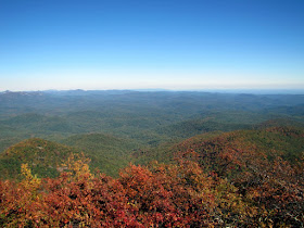
The payoff at the top is without peer. At the top, there is the first fire tower built in the Geogia, way back in 1912. The fire tower was phased out of use in the 70’s and some industrious youth built a viewing platform there. On the top of this platform, it is said that you can see for 100 miles on a clear day in any directions. There is no clearer, unobstructed view within the state. The video at the bottom tries to capture this effect by standing in the middle of the platform and spinning slowly in a circle. I fear the pictures do not do proper justice to this incredible natural vista. And the October setting allows the first hints of turning Fall leaves. There’s an Indian Legend that says that the mountain is inhabited by fire breathing demon people, but they must have moved away some years ago.


So if you are looking for a challenging hike, or a tremendous mountaintop view, or a chance to see the Fall colors, this is just the ticket. I’ve seen a bevy of beautiful places on my journeys, but this might very well be the prettiest. I would love to the see the Sunset from this vantage point, but that would mean climbing down a steep trail in the dark. Rabun Bald, I thank you for an enjoyable Sunday Afternoon.


Trail Essentials
Approximate Time: 2-2.5 hours
Approximate Distance: 4 miles
Features: Wilderness, Tremendous Mountain View

Overall Rating: A

Scenic Quality: A+
Athleticism: A+
Solitude: A
Value: A
Parking: Free
Hours of Operation: No Formal listing
Facilities: None
Maps: here
County: Rabun


Yellow Branch Falls

Heaven for the Norse and Waterfalls Enthusiasts map
From Yellow Branch Falls


I feel a little funny about this one, but it’s something I said I was going to do earlier in the year but hadn’t yet. Up to this point, all of the posts have been about subjects that remained within my adopted home state of Georgia. But this one’s in South Carolina. However, it does meet within my stated purpose to talk about great day trips launched from Atlanta. This place resides about 26 miles North up I-85 up off exit one on Highway 11 just within the Palmetto State, and it’s an easy 2 hour and 15 minute ride from Atlanta, even closer if you, like me, live a bit up 85 already. The spot is a great little jaunt with a waterfall hike in the Sumter National Forest called Yellow Branch Falls and the Trail of the same name.


This part of the Sumter National Forest sits about six miles North of Walhalla, SC. On the left hand side of the road, you will see a sign for the Yellow Branch Falls Picnic Area. There is a little nature trail located here and primitive, but well maintained restrooms. From here you can read signs that say 1.5 miles to the endpoint and your destination, Yellow Branch Falls.


Yellow Branch Falls are a 50 foot high, and 75 foot wide cascade nestled into a forest cove. The pictures to me don’t truly do this site justice because the water trickles over at dozens of different locations that simply doesn’t give a grand flow of roaring water. But considering the expanse of the waterfall, it is a gorgeous spot that is sure to inspire awe. Also, unlike a lot of waterfalls, there are no guardrails or viewing platforms making your experience here much more intimate and tactile. You can sit right where the water hits the stream below and easily feel like you are a part of the falling water.


The hike itself is a moderate trek, up and down the ridgeline to the falls. You cross back several times, with at least three of them being across water, so you should be prepared to get your feet wet. And at the base of the falls you are assuredly going to want to get closer, which will wet your feet even more. The hike out and back totals 3 miles round trip, and with the elevation gain and loss of about 370 feet makes the journey a fitting physical endeavor.


So if you are looking for a neat place to go, just a little outside of Atlanta, I would suggest the wilderness North of Walhalla as a worthwhile trip outside the borders of Georgia. This hike is also very near two other locations I will comment on later, the Stumphouse Tunnel and Issaqueena Falls (links here), which paired together (and easily done in a single outing), make the two hour ride very much worthwhile.


Trail Essentials
Approximate Time: 1.5 hours
Approximate Distance: 3 miles
Features: Wilderness, Waterfalls, Creeks

Overall Rating: A

Scenic Quality: A
Athleticism: A
Solitude: A
Value: A

Parking: Free at Picnic Area
Hours of Operation: Daylight hours
Facilities: Outhouse at Picnic Area
Maps: At Trailhead, here at bottom
County: Oconee County, South Carolina

Brushy Mountain Tunnel

Another Georgia Abandoned Tunnel Map
From Brushy Mountain Tunnel


The Greater Atlanta Area is home to a number of interesting things to see and do. Some are better or bigger than any other place in the world. A notable example of this is the longest paved bike trail in the United States, a path that starts in Smyrna, Georgia and leads all the way to Weaver, Alabama, just outside Anniston. The Georgia portion of this path is called the Silver Comet Trail. I have now biked the entirety of the Silver Comet, and what I believe is the most notable spot on the trail is the Brushy Mountain Tunnel.


This 800-foot long, three story high tunnel runs right through Brushy Mountain. The tunnel was originally built in 1912, but simple observation shows walls of concrete. What occurred was that the tunnel was expanded (principally heightened) in 1968 to accommodate modern three tiered freight cars that became more prevalent in the modern era. Seaboard Rail stopped using this passageway in 1988, which allowed the tunnel to take on its new role as an actual destination on the Silver Comet.

The Best way to get there by bike is to get on at Rambo or Paulding and head west which is either 8.5 or 11.5 miles away, respectively. You will drive over the 750 foot long Pumpkinvine Creek Trestle and through the Paulding Wildlife Management Area, which makes up the prettiest stretch of the trail, in my opinion. It is also the longest portion between trail heads at 11 miles, so you need to be prepared because there are no restrooms or places to get water or other necessities. If you continue on to Rockmart, which will take your one way distance up to 18.25, you get what I think is the best slice of the Silver Comet Trail Pie.


If you are looking to hike to the tunnel, or just want a shorter bike trip, the best thing to do is start at Coot’s Lake and travel the 2.6 miles East to the tunnel, which makes for a pleasant 5 mile walk on paved surfaces. The grade to the tunnel is upward from both directions but long and gentle.


I recently set out to capture the entirety of the trail on film and I include a bit longer video of me crossing through the tunnel below. The photos come from a different day earlier this year. As I have come to truly enjoy having the Silver Comet Trail right in our backyard, I think its most interesting attraction, the Brushy Mountain Tunnel, sitting slightly less than an hour away from Atlanta, is deserving of mention in its own right. 


Trail Essentials
Approximate Time: 1-1.5 hours (Hiking)
Approximate Distance: 5 miles (Coot’s Lake to Tunnel and back)
Features: Lakeside view, Large Tunnel

Overall Rating: B

Scenic Quality: A
Athleticism: C
Solitude: B
Value: B
Parking: At any of the Trailheads mentioned, Free
Hours of Operation: Daylight hours
Facilities: At Palding (Standard) or Coot’s Lake (Portables)
Maps: here, not really needed
County: Polk