“The Laving Laurel Turned my Tide” Map
Though I don’t have any precise metrics, I believe from personal anecdotal evidence, that Lake Lanier is the most talked about and visited outdoor recreation spot by most Atlantans. And for that reason, I have personally shied away from our man made wonder just an hour North of us. I look for peace and quiet, and massive throngs of people are not conducive to this goal. But I have been told that one of the better hikes near to our area runs along Lake Lanier. It’s called the Laurel Ridge Trail, slightly under an hour away up GA 400 or I-85.
The trail runs, by most accounts 3.8 miles, although the trail markers clock it in at a flat 4.0. It runs a nice continuous loop, and we began at the Lower Overlook Park, where the parking is free. From this point, the trailhead lies just behind the restrooms and takes you immediately across Buford Dam Road.
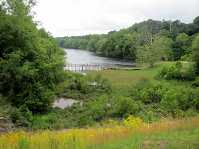
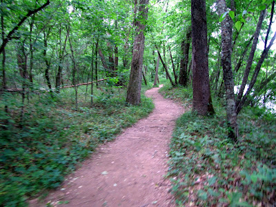
The trail is well marked and takes you through a series of overlook where you get nice views of Lake Lanier or the Chattahoochee River. It would be best explored in the early spring months or winter as the views are often blocked or diminished by trees full of leaves. The overlooks, except for the first one, are still enjoyable to the naked eye, but the obstacles hinder photography. The path is mostly compact soil, with some boardwalk through the “wetland” portions, and some pavement near the more traditional recreation sites. Although there is no monumental physical challenge, the path does rise and fall enough from ridge to shore and back to make it an adequate workout. I would still rate it as easy, however, I would not say it was simple.

At about the ½ mile mark, the Buford Dam is both visible and accessible on your right. Though this would not be technically on the trail, it would be foolish not to add this short jaunt down to the dam. I will talk more about Buford Dam in a later post because most other sites treat it as a separate trek, as short as it may be. If you cross the wooden bridge and follow that trail it will meet up with the Laurel Trail maybe two-tenths of a mile up from where you departed, adding, maybe, another ½ mile to your journey.

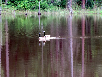
The trail is good for wildlife watching and people watching. Along the way, we saw several smaller birds, Ducks, Goats, and a Deer. On the Lanier side, there are benches and swings where you can view boats and water skiers pass by. The day we went was a little on the cold side and overcast, so we were met with a little more peace and quiet that you may encounter. However, there are stretches of the trail that take you away from the congregation of people that I’m sure there will be some serenity when you go. Additionally, there are wetland areas, a nice little pond, and a beaver dam. A good portion of the trail runs along a petite stream known as Rocky Creek. I will caution you that the trail crosses roads in three locations, two of them being the busy Buford Dam road, so cross with caution. Other than this, it would be an excellent spot for children. When you come out of the long quiet part of the trip, the trail empties out at a playground (at around 2mi). I should also note that under current rules, Dogs are not allowed on this trail.
Most of the hiking I do seems to be goal oriented. Let’s go see this waterfall or climb this mountain or whatever. There is another type of hiking that encompasses the process more than the accomplishment and I appreciate these as well, but they don’t make the most intriguing articles. At the end of the trail, I told my most frequent travelling companion, that within this category, I would rate the Laurel Ridge Trail as the second best trail of the sort behind the underappreciated Stone Mountain Loop Trail. My fellow Traveller thought this one was even better than that.
So if you are looking for nice little day in the great outdoors, and want to get your legs and heart moving a little, the Laurel Ridge Trail deftly suits the bill. And considering its close proximity to most of us, it is definitely worth the trip.

Trail Essentials
Approximate Time: 1-2 hours
Approximate Distance: 3.8 (4.6 with Buford Dam Area)
Surface: Compact Soil, Boardwalk, Wooden Bridges, Some Pavement
Features: Riverside, Creekside, & Lake Side Walk, Lake Vista Views, Buford Dam, Wildlife
Overall Rating: B
Scenic Quality: B
Athleticism: B
Solitude: C+
Value: A
Parking: Free at Lower Overlook Park (paid parking at some Lanier locations)
Hours of Operation: Daylight Hours
Facilities: Throughout the trail
Maps: here
County: Gwinnett County
 |
| From Laurel Ridge Trail Lake Lanier |
The trail runs, by most accounts 3.8 miles, although the trail markers clock it in at a flat 4.0. It runs a nice continuous loop, and we began at the Lower Overlook Park, where the parking is free. From this point, the trailhead lies just behind the restrooms and takes you immediately across Buford Dam Road.
The trail is well marked and takes you through a series of overlook where you get nice views of Lake Lanier or the Chattahoochee River. It would be best explored in the early spring months or winter as the views are often blocked or diminished by trees full of leaves. The overlooks, except for the first one, are still enjoyable to the naked eye, but the obstacles hinder photography. The path is mostly compact soil, with some boardwalk through the “wetland” portions, and some pavement near the more traditional recreation sites. Although there is no monumental physical challenge, the path does rise and fall enough from ridge to shore and back to make it an adequate workout. I would still rate it as easy, however, I would not say it was simple.
At about the ½ mile mark, the Buford Dam is both visible and accessible on your right. Though this would not be technically on the trail, it would be foolish not to add this short jaunt down to the dam. I will talk more about Buford Dam in a later post because most other sites treat it as a separate trek, as short as it may be. If you cross the wooden bridge and follow that trail it will meet up with the Laurel Trail maybe two-tenths of a mile up from where you departed, adding, maybe, another ½ mile to your journey.
The trail is good for wildlife watching and people watching. Along the way, we saw several smaller birds, Ducks, Goats, and a Deer. On the Lanier side, there are benches and swings where you can view boats and water skiers pass by. The day we went was a little on the cold side and overcast, so we were met with a little more peace and quiet that you may encounter. However, there are stretches of the trail that take you away from the congregation of people that I’m sure there will be some serenity when you go. Additionally, there are wetland areas, a nice little pond, and a beaver dam. A good portion of the trail runs along a petite stream known as Rocky Creek. I will caution you that the trail crosses roads in three locations, two of them being the busy Buford Dam road, so cross with caution. Other than this, it would be an excellent spot for children. When you come out of the long quiet part of the trip, the trail empties out at a playground (at around 2mi). I should also note that under current rules, Dogs are not allowed on this trail.
Most of the hiking I do seems to be goal oriented. Let’s go see this waterfall or climb this mountain or whatever. There is another type of hiking that encompasses the process more than the accomplishment and I appreciate these as well, but they don’t make the most intriguing articles. At the end of the trail, I told my most frequent travelling companion, that within this category, I would rate the Laurel Ridge Trail as the second best trail of the sort behind the underappreciated Stone Mountain Loop Trail. My fellow Traveller thought this one was even better than that.
So if you are looking for nice little day in the great outdoors, and want to get your legs and heart moving a little, the Laurel Ridge Trail deftly suits the bill. And considering its close proximity to most of us, it is definitely worth the trip.
Trail Essentials
Approximate Time: 1-2 hours
Approximate Distance: 3.8 (4.6 with Buford Dam Area)
Surface: Compact Soil, Boardwalk, Wooden Bridges, Some Pavement
Features: Riverside, Creekside, & Lake Side Walk, Lake Vista Views, Buford Dam, Wildlife
Overall Rating: B
Scenic Quality: B
Athleticism: B
Solitude: C+
Value: A
Parking: Free at Lower Overlook Park (paid parking at some Lanier locations)
Hours of Operation: Daylight Hours
Facilities: Throughout the trail
Maps: here
County: Gwinnett County

No comments:
Post a Comment