Dukes Creek Falls

Chasing Waterfalls 2010 –Episode II Map
From DUKES CREEK FALLS

I like the Alpine City of Helen, Georgia for all the wrong reasons. I’m not a huge fan of their take on food or German Culture. It is nice, I guess, but feels a bit contrived, but I might be oversensitive to this stuff as I went to college in the most contrived city on Earth. What I like is that it remains the most open and inviting of all North Georgia cities and that it is a great base point for many exhilarating treks the mountains. It is the third most travelled to destination of all Georgia cities. So what do you do when you get there: Go see something beautiful in the nature that surrounds it. A short distance away is a fantastic waterfall, one in which these photos actually cannot do justice, known as Dukes Creek Falls.


Dukes Creek Falls drops from Dukes Creek, not from it. The 150 foot drop into the gorge comes from Davis Creek. It is so large and cascading it is nearly impossible to take in as a whole. But can be taken in quite nicely in smaller sections. It is the most majestic of the four Helen Area waterfalls and makes for a simple quick excursion to add to your Alpine itinerary.

The trail itself is marvelously maintained and easy to navigate. It does descend about 400 feet through a serious of three switchbacks. But over the 1.1 miles down the path almost feels flats. At the parking area, you get one of the better views of Yonah Mountain. About .1 mile down, there is a viewing platform that allows a distance view of the upper portion of the falls. Along the second switchback near the midpoint of the trail, you begin to hear the sounds of strong falling water. Shortly after this point, you will get your best view of the whole of the falls, albeit not a good view as it is obscured by trees and may be invisible when the trees are full with leaves.


At the very bottom, there are some nice observation decks, where the bottom of the falls literally envelopes you. And the deck continues a bit further where there is an additional smaller fall along Dukes Creek. Of course, after getting your fill of the falls you have to climb out, which will be tougher. But it really isn’t all that bad, I would place it at about half the difficulty of Stone Mountain.


I would rate this as one of the better short hikes in Georgia. At 2.2 miles with the climb out it would constitute some exercise. The beauty of the falls offers a tremendous payout for your effort. Dukes Creek also flows into Smithgall Woods a few miles South if you wish to do some additional walking.


Trail Essentials
Approximate Time: 1 hour
Approximate Distance: 2.2 miles
Trail Surface: Compact Soil, Boardwalk, Stairs
Features: Waterfall, Vista views

Overall Rating: A

Scenic Quality: A+
Athleticism: B
Solitude: B-
Value: A+
Parking: $3 (Mar 2010)
Hours of Operation: Daylight Hours
Facilities: None
Maps: Not needed
County: White

Andersonville National Cemetery

They hover as a cloud of witnesses above this Nation. Map
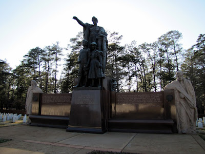
Entrance to Andersonville National Cemetery Statue
From Andersonville
(Part II of a three part serious on my trip to Andersonville, Part I here, Part III here)


The place that I have gone in Georgia that has had the most profound impact on me is my visit to Andersonville earlier this year. So much so, that I have decided to discuss it in three parts. In part one, I talked about the Andersonville Civil War Prison itself and the Prisoner of War Museum, and I’ll admit that I pontificated a little bit. In part two, I will try to avoid that as I discuss the Andersonville National Cemetery.
Tombstones of Unknown Soldiers

If you wish to view this place as a good place to take a walk, the additional 1.2 miles here added to the prison site takes the total distance travelled up to 2.7 miles. And if walking isn’t an option, you can travel most of the site by car, though you will have to get out if you are looking for an individual gravesite. And, I must add, even though I walked it, I don’t think that is the way it should be taken.  It should be something more. It is a place of honor: an honor of the solemn trust and memory of those who fought and died for our country.
Monument to Illinois Fallen

The first part of the cemetery contains the 13,000+ graves of the men who died during interment here during the Civil War, most from the armies of the Union States. The grave marked number 1 belongs to Adam Swarner of New York and unfortunately the place closed before I could find the last grave. There are monuments erected by every state that had soldier die in Andersonville throughout these graves. The graves line up in perfect lines on short white marble throughout the middle Georgia landscape. 921 of these graves are marked unknown.
The First Gravesites at Andersonville

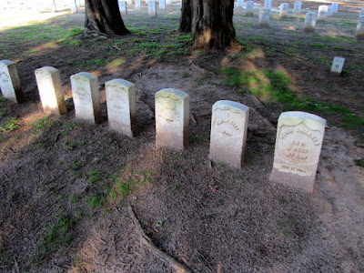
Notable among the graves are six gravestones set apart from all the others, not in a place of honor, but in a place of shame. They were the six known as the “Raiders.” They were executed at the Prison for crimes within the prison. With no officers held at Andersonville, the swelling numbers of enlisted men fell into anarchy, and the guards lacked both the manpower and probably the will to do anything about it. The group numbered depending on reports somewhere between 50 and 500 (with best estimates placing it between 75 and 150) and they would steal, intimidate, beat, and sometimes murder their fellow inmates in order to secure what valuables the other prisoners had. After a prisoner named Dowd was beaten and had his money and watch taken, he complained to the guards, and this caught the attention of Captain Henry Wirz, the head of the camp, who decreed that all rations would be cut off until the Raiders were turned in. Building on less well organized protection groups built from squadrons housed together; a rival gang, or rather, police force was formed called the Regulators. They brought the Raiders to justice, held a trial within the prison of their peers, and the six chieftains were court-martialed and sentenced to be hung. The remaining Raiders were forced to run a gauntlet of other prisoners as their penance being beaten by those they formerly terrorized. The six that were hanged were: John Sarsfield, William Collins, Charles Curtis, Patrick Delaney, A. Munn, and WR Rickson (AKA Teri Sullivan), though there is some controversy as to whether these were their real names.
The Andersonville Raiders Graves Set Apart

In addition to the prisoners who died here, the site is a National Cemetery and more of our fallen soldiers have been buried here since the Civil War, pushing the total to above 18,000, representing virtually every war since. Two of whom were Congressional Medal Of Honor recipients. James Wiley fought in the Civil War and died during internment at Andersonville and he is credited with the capture of a Georgia Regiments flag at Gettysburg. The other is actually an “in memory of” headstone, as his body has never been recovered, and that belongs to Luther Story, who was awarded for taking out a truck full of enemy combatants singlehandedly near Agok during the Korean War.
Modern Graves at Andersonville National Cemetery

As I said before, this is a solemn place and the feeling of sadness is palpable. Some wish to attribute this to some sort of paranormal activity, and I like nothing better than a good ghost story, even if it is just a story. But it just doesn’t seem right to do that here (the stories are easy to Google if you need them). Andersonville National Cemetery deserves more respect than that. This place coupled with the POW museum and the Prison, is a must see for all Americans who are able to reflect on our past, our fallen brothers, and the hopes of our future.
Andersonville Prison's Dead

Trail Essentials
Approximate Time: 1-1.5 hours
Approximate Distance: 1.2 miles
Trail Surface: paved and grass
Features: Grave markers and statues
Overall Rating: A
Scenic Quality: A
Athleticism: C
Solitude: A
Value: A
Parking: Free
Hours of Operation: 8am – 5pm
Facilities: At the POW Center
Maps: Not needed
County: Macon

Ivy Creek Greenway

BEHING BUSTLING BUFORD MAP
“Woodward
From Ivy Creek Greenway

I went to the Gwinnett Environmental & Heritage Center (GEHC) a short while ago, and thought after walking about four miles in the area that I ought to check more of this place out by bicycle. I went back about a month later, this time with friends and bikes. Little did I know that I was supposed to cut through the back end of an apartment complex, but in doing so this time, I discovered the beauty, history, and fun that is the Ivy Creek Greenway .
“Bridge

Starting as before at the GEHC, We cycled down to where the Greenway begins. Now you could hike this route, and with the current 5.4 round trip it would not be a bad hike (out and back). But I agree with my second most common travelling companion who thinks that bikes can make an average outdoor excursion great. The first 1.4 miles are paved, reasonably flat (the worst climb is actually out of the greenway up to the GEHC parking lot). And it takes you along the homestead trail and across a bridge into the AMLI at Mill Creek Apartments. Just behind the apartments there are some nice water cascades and the ruins of the Woodward Mill, including an old rusted water mill (of course, we had to dismount to see properly). There seems to be closer access to these ruins either by parking at the Courtyard By Marriot or just off the I-85 southbound 20 exit headed East toward Lawrenceville. I like ruins and these are pretty nice.
“The

The path then follows under some major roads like the I-85 exit ramps and SR 20. The drawback is obviously the traffic noise constantly in the background. On the plus side, there are no active roads to cross, and those overpasses can provide some much needed shade if you want to take a break. Just as you approach the Mall of Georgia and the Georgia Wildlife Federation Land, the trail turns to gravel, so if you are walking or have the right type of bike you can continue (we watched a roller skater turn around here in sadness). There does seem to be a new paved access point here allowing the possibility of parking at the Mall of Georgia.
“Ivy

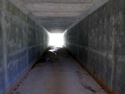
As you continue, a short ways up on the right hand side, there is a couple of entryways into the Mill Creek Nature Center. It is either incomplete (as the idea for the center came about in 2003, or damaged in the floods—as it was taped off on the day we went—there are still places you can sneak in, but we didn’t). You then cross under a couple of more roads, the final one being Gravel Springs Road, where the path currently, very abruptly ends at the other side of the tunnel. We spent some time there picking wild blackberries which my friend cooked into a tart the following weekend. We then headed back the way we came.
“Mill

It seems like there are plans on the board to connect this greenway to Bogan Park and George Pierce Park, the latter will actually connect it to the Suwanee Creek Greenway making this the premiere paved road biking attraction in Gwinnett County. But until that happens, it is still one of the best flat surface trail rides or walks in the area, complete with a few very nice diversions.
“tunnel

Trail Essentials
Approximate Time:
Approximate Distance:
Trail Surface: ½ paved, ½ Gravel
Features: Heritage Center, Mill Ruins, Riverside Views, Bridges, Wetlands

Overall Rating: B

Scenic Quality: B
Athleticism: C (almost flat)
Solitude: B-
Value: A
Parking: Free
Hours of Operation: Daylight hours for GEHC parking
Facilities: At GEHC, if open
Maps: here, not really necessary
County: Gwinnett

Yonah Mountain

OFF LIMITS MOUNTAIN NO MORE Map
Yonah Mountain
From 2010-06-27 Yonah Mountain
Now I know most of us have gone to Helen a time or two, I’m no exception. And I think that most of my readers know my predilection for walking up mountains. And for the duration of this journal there has been one mountain passed by every time on that trip to Helen: Its familiar wave like swoosh at the top with a granite smile. It stood there for almost 8 years virtually off limits to us. I am, of course, speaking of Yonah Mountain about 1 hour and 45 minutes North of Atlanta.
Yonah Mountain View
The reason for the lack of access was that although the mountain is owned by the U.S. Military, there was no public access. The folks who owned the property around the mountain made no accommodations for people who wanted to hike the mountain, due to misbehavior by users. Apparently, the land is federal property, so local authorities have no jurisdiction there, so it became a sort of lawless place filled with juvenile and sometimes illegal hijinks. So prior to October of last year you had to complete a three mile walk along paved roads just to get to the base of the mountain. Fortunately, some outdoorsy Georgia Do-Gooders (The Land for Public Trust, The Southeastern Climbers Association, & The Access Fund) were able to raise money and buy a tract of land that connects public road to the mountain, and thus the Yonah Mountain Trailhead was born late last year.
The Granite Face of Yonah Mountain

I’ve seen the hike marked as short as 2.1 miles up the mountain to as long as 3.3 miles. Worst case, I figured, it would be 2.5 to three hours (considering the round trip). I kind of saved this one for a time when one of my favorite fellow travellers, my brother, was in town, so it would be as new to me as to him. So we ventured up the last weekend of June this year. The trailhead is fairly easy to find taking 75 North out of Cleveland, turning right on Tom Bell Road (across from the West Family Diner), taking an immediate left on Chambers road, and then a left on the 2nd gravel road. There is ample parking and even some primitive facilities.
View from the midpoint

I was told the trail was moderate to strenuous in difficulty which I would agree with, primarily due to the elevation gain of about 1400 feet over the two or so miles. The reason for the discrepancy in distance is that there are several places you could walk different ways to see different things. The mountain is sort of a mecca for rock climbers and bouldering enthusiasts. As a matter of fact, that’s exactly what the government uses it for, the mountaineering phase of Ranger Training (so if you are headed up it is useful to make sure they are not there as the mountain will be legitimately closed at those times - Forest Ranger Service 706.754.6221). There were only a few stretches that I would consider very steep and difficult. And there is another outhouse type structure at about the midpoint up the mountain. Before you get to that point, there is a nice open field with good views of the land below and a great vantage point for the rocky face of Yonah Mountain.
View from atop the granite face of Yonah

Now normally, I would have a bunch of really cool photos at the top of the mountain. But in all honestly, I never made it all the way up, but only about 90% of the way there. I wasn’t done in by the physicality of the journey, but by the weather. Even though, the weather service said that there was only a 30% chance of scattered showers, a severe thunderstorm hit the mountain just as we reached the top of the granite face. Now this is a very rustic mountain with no safety features and there have been deaths recorded as recently as 2008. There will be a short video at the bottom of this post. Now, I would never recommend climbing a mountain in a storm, but if you climb a couple of hundred times you are bound to get caught in one sometime. I’ve been stuck a dozen or so times myself and I always think the same thing: “If I survive this, this is so awesome.” We saw clouds swirl beneath us, covering everything in sight, and then disappear in a flash as a strong wind entered the picture. It was life threatening and life affirming. Since I am writing this, “it was so awesome.” It also made photography a bit difficult, and the photos won’t do it justice.
and then the rains came in

I write this now knowing full well I will get back there this year because it is the single most important new trail in our area and I am really excited to relay the news. Great views, good physicality, and just about everything I look for in a trail. If you go, be careful, and remember the 8 years without access to Yonah Mountain: Be gentle to the surroundings and polite to the mountain’s neighbors.


FOR HIKING BLOGS
Trail Essentials
Approximate Time: 1-2 hours
Approximate Distance: approx. 5 miles round trip
Trail Surface: Rocks, Compact Soil,
Features: Vista Views, Rocks, the odd rock climber or rapeller.

Overall Rating: A

Scenic Quality: A-
Athleticism: A
Solitude: B+ (but that will probably change for the worse)
Value: A
Parking: Free
Hours of Operation: Daylight Hours
Facilities: Trailhead, Halfway up the mountain (Outhouse variety)
Maps: None
County: White County