Buford Dam

The Birthplace of Lake Lanier Map
From Buford Dam


Recently, there has been a lot of talk about the dangers of the Chattahoochee River with outdoor enthusiasts being in need of rescue. In more extreme cases, drowning occurs. And it seems that all the blame for this goes to a little marvel of modern technology known as the Buford Dam.

Built in 1956, the Buford Dam does several things for us in Metro Atlanta besides try to kill us. It does a nice job of Flood Control with only two significant floods South of Dam since its inception. It provides power; it aids in wildlife management; and it helps with our water supply. In order to do these things, it has a continuous release Schedule that is irregular. Water is released from Lanier daily, but some days it’s a little and some days it’s a lot. The more water that is released the more dangerous the river becomes, so check at the phone number (770) 945-1466, so you will be adequately prepared.

Visiting the Dam is an interesting excursion in its own right. Some write this up as a trail, and so I will do the same, but I warn it is very short at only about a mile, if you park at the Lower Overlook Park to save on parking fees at the Dam itself. On the bright side, it is a very easy excursion for those who can do limited physical activity, the physically-challenged, or even small children.

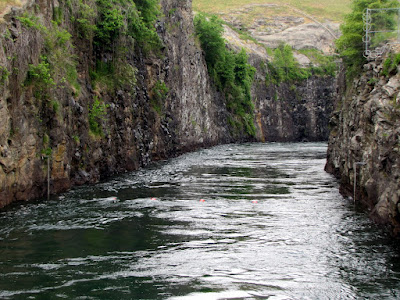
In the one mile space, 3 things jump out at me of interest. The most obvious of which is the rocks and formations of the dam itself. There is a nice little steel frame bridge with great views of the dam or down the Chattahoochee. The second is the sheer clarity of the water. As the water released from Lanier comes from the bottom of the lake, it is crystal clear in spite of the heavy boat usage there. Finally, and probably the most odd, is the wildlife in the area. Of course there’s ducks and fish, and that’s to be expected. But there are also a fair number of goats living just inside the fences at the dam.
You can also watch the fisherman at work (or do they call it play) as it is popular for this activity.

So if you looking for an interesting side excursion on your trip to Lanier or a short jaunt off the LLaurel Ridge Trail Laurel Ridge Trail on your more extensive hike, the Buford Dam is a shouldn’t miss place just at the Forsyth-Gwinnett County Border. On a beautiful day, it is another option to get you outside. And the sirens you hear are announcing the release of water.

Trail Essentials
Approximate Time: ½ - 1 hr
Approximate Distance: 1 mi.
Features: Dam, River View, Wildlife

Overall Rating: C+

Scenic Quality: A-
Athleticism: C-
Solitude: C-
Value: B
Parking: Free (lower overlook park) Charge at Dam Parking
Hours of Operation: Daylight Hours
Facilities: At Lower Overlook Park
Maps: None, Follow Laurel Ridge Trail to Dam (marked trail), and return same way
County: Forsyth

Sweet Water Brewery

FREE BEER (4 days a week) Map
From Sweetwater Brewery


About two decades ago, I was really into beer. I did all the stuff you would think a guy who was into beer would. I even made my own, and got pretty good at it. But for the last decade of my life, I’ve steered away from beer first toward neutral and then less neutral spirits. But it doesn’t mean I don’t still appreciate a good beer. And I am glad that Atlanta has got a worthy craft brewery to represent us in the Sweetwater Brewing Company, just off the Peachtree Exit on I-85, located at 195 Ottley Drive in Atlanta.
From Sweetwater Brewery
Now this is not exactly a secret, as the crowds can attest, but it doesn’t mean it’s not worthwhile. Every Wednesday, Thursday, & Friday from 5:30p-7:30p (and Saturday from 2:30p-4:30p), these guys basically open their doors to the public to visit and taste some fine Georgia draft beers. They do two things: they operate a tasting room and they have a tour of the facilities. They are both technically free, though most patrons will opt to spend the $8 on a souvenir glass because you will get significantly larger “tastes” of the beers and they make nice keepsakes.
At the tasting room, you have a choice of their 5 Standard Brews: 420, IPA, Sch’wheat, Georgia Brown, and Blue, as well as one seasonal brew, they call “Catch and Release,” which was for us something called Motor Boat. As I knew before coming there, these guys know what they are doing and the beer is solid.
I would rank IPA & 420 as very good; Georgia Brown, Motor Boat, and Sch’wheat as good (though I’m not partial to wheat beers—I believe it’s done nicely); and Blue as just plain weird. Blue has an odor of Boo Berry cereal and that olfactory experience is so discordant that I can’t even tell you what it tastes like. That being said there’s a market for less beer-like beers and that’s apparently what they are going for. I do want to reiterate that the other beers were good to very good. Heck, I can honestly say that “I don’t often drink beer, but when I do I normally drink 420.”

The tour is a little underwhelming. After touring various whiskey distilleries, I probably expected a bit too much from this. With the large crowd it is hard to accomplish any kind of meaningfully informational tour, and I bet that most of the folks there didn’t really care that much. When they asked if anyone brewed beer at home only me and one other tour patron raised their hand. But considering the obstacles, it came off quite well. The impression I received was that this open house and tour was Sweetwater Brewery’s honest and sincere way to say thanks to its patrons. This type of heartfelt connection to a company’s customers is pretty rare, but nice to witness. It was also nice that the second half of the tour was held inside the huge walk-in cooler, allowing a nice way to beat the heat, if just for a few moments.

So if you like beer or know someone who does, and are over the age of 21 (this is important – no children are allowed), a trip to the Sweetwater Brewery is good way to spend a few hours of your day on the way to some Atlanta evening destination. Be prepared to drink, for crowds, and to walk a short distance from parking to the buildings. As I said, they seemed to thank me for my patronage, this article is my Thank You to them just for being there.


Harbins Park

Gwinnett’s Bike Park Map
From Harbins Park


Really nice places to Bicycle are hard to find. They can be too short or too easy or too long or too difficult. Especially, when you are talking offroad biking. I’ve seen fellow rider who barely bat an eye at 30 miles on paved surface quit after a couple of miles of singletrack dirt. And this is because Mountain Biking is pretty hard work. One of the better places I have found for the novice to intermediate mountain bicyclist is Harbins Park
near Dacula, GA.

The Park is relatively new being built late in 2009. And it appears to be constructed with the bicyclist as the primary focus, which makes it the first of its kind in Gwinnett County. There are trails marked for Equestrian and Hiking use, but only the 4.5 miles of paved trail are the usages combined, giving the Bicyclist the right of way on his path (Maps downloadable here).

The Bike Paths are a series of loops that are rated intermediate. Because Mountain Biking is difficult, I’m not always looking for the hardest thing I can find. I’m looking for a place I can have a bit of fun and work up a bit of sweat over an hour, or maybe two hour period. Harbins is probably the best I’ve seen fulfilling these requirements.

There’s also a pretty little stream, some form of runoff of the Alcovy River, which makes for a pleasant picture and calming sound of rushing water. It also makes a good place for a break in a pastoral setting. There is also a big hill near the telephone lines, which I’m simply not crazy enough to tackle, but had some fun watching others risk they’re necks. Another nice thing is that the longer paved trail intersects the bike trail in several spots which allows for an easier break of flatter Earth or to back out and quit if the feeling should present itself.

If want a really hard dirt trail, skip this one and go to the nearby Fort Yargo. If want pretty easy, skip this one, and head to the nearby trail at Tribble Mill Park. But, if you are like me, and looking for a medium challenge like me, somewhere in between, Harbins Park in Gwinnett is just right. There’s a nice video by Singletracks on YouTube here.


Mason Mill Park (Decatur Waterworks)

The Old Decatur Water Works and more to come Map

From Mason Mill Park

I read every email I get and respond to all of them—eventually. The subject of this post was first suggested to be by Chris F via email in 2007. It was also listed as a regret in an email to me by Dave K. of urban outdoors back in 2009. So in characteristic Baboon fashion, I made my jaunt to this location in the Spring of 2011. Better late than never someone once said. The best reason I can give for the delay is that it is really a small park, better suited I had thought for a stop by than an excursion on its own. Mason Mill Park in Decatur, Georgia packs a lot of interesting stuff in a small package, just 20 minutes outside of Atlanta.

Probably, the most famous thing about this park is that it houses the old Decatur Waterworks ruins. Built in 1906, this site provided water to Decatur utilizing South and Burnt Fork Creeks until the 1940’s. Since then the structure has fallen into decay and ruin, but I say that in a good way. They are known by locals simply as “The Ruins,” and like many structures off the beaten path they have also fallen prey to vandalism or graffiti, depending on your perspective. I found the graffiti fascinating, something about the entirety of the work or the irony of a man made structure placed in nature, getting overrun by nature’s entropy, being covered with man-made attempts at communication. I digress, let’s leave it as it is a good place for photos.

The second thing is the Park itself, or rather the Park inside the Park. Apparently, when the waterworks were an operating facility, the company had built a little park out of the greenspaces nearby. As the Mason Mill Park expands it is encompassing parts of the old park. The finest feature of this old Mason Mill Park is the stone bridge that crosses Burnt Fork Creek. The creek is quiet, babbles in places, and has some ruins of a dam structure just a little way North of the Bridge.

The final thing is the Hiking and Biking. I’m not going to write this up as a hiking blog, because the trail is strange, short, and undefined. This is more of the type of place you simply explore around for a while, rather than try to accomplish any one thing. I spent about 2 hours there, and may have spent more, if I didn’t have to meet someone for dinner. On the Bicycling side, this area is nearby and easily explored on Mountain Bike. Also, it appears the PATH Foundation is building a paved connector that will eventually link North Druid Hills to Emory University. There are some that oppose this, and I admit that I like a dirt path more than paved personally, but I understand the average bicyclist wants easy paved roads. And the added interest in the area brings preservation.

Well, there you have it. Mason Mill Park contains the remnants of the Decatur Waterworks, a pretty little creek, and a future bicycle path. That’s packing a lot into a small space. To get to these places within the park, you have to travel to a dirt road at the far end of McConnell Drive past the Tennis Courts, just so you know.


Sprewell Bluff State Park

The Flint River in Danger again map
From Sprewell Bluff


Whenever I read a story about Atlanta’s water supply and the disputes surrounding, one side note has always intrigued me. Basically, in addition to the creation of reservoirs on the Etowah, Chattahoochee, and Savannah rivers, there were plans to build a reservoir on the Flint River. But, due to its natural beauty, then Governor Jimmy Carter gave the Flint River a pardon. I know that the Flint flows through areas of Carter’s childhood, but I wanted to see what he saw. And I wanted to see it before it goes away. The best place to look is at the former proposed site of the dam, which is now Sprewell Bluff State Park, located just under 2 hours South of Atlanta, near Thomaston.
Now the other curious thing about this park is on the state web page under activities, it lists among the usual culprits, the quite unusual rock skipping. It’s not unusual to skip rocks per se, but it is unusual to list that among things to do. At Sprewell Bluff, they even have an annual rock skipping contest on Labor Day weekend. Even though I’ve said it was strange, as you stand on the bend of the river, you can’t help but think, “This is a great place to skip a rock.”

There is also a 3 mile hiking trail. it runs up and down the bluff to the river in a series of loops with out and backs at each edge. At one edge you head out to a natural dam, and at the other you pass by an overlook with a nice birds-eye view of the river and it ends at the aforementioned Rock Skipping place. It’s a nice peaceful trail with some elevation gain and loss, enough to call it decent exercise. And the river itself is beautifully tranquil. After walking the trail, we ended the day, grilling burgers at the side of the river.


So what did Jimmy see? The natural beauty of the Flint River winding its way through rocky bluffs, a great place to fish or canoe, or maybe he just sat there and skipped a rock. Any way you slice it, Sprewell Bluff State Park is peaceful getaway, I’m glad to see preserved intact. With the water problems we have, let’s hope that the idea of damming the Flint is not rekindled.

Trail Essentials
Approximate Time: 1-1.5 hours
Approximate Distance: 3 miles
Features: River Walk, Shoals, Long distance River Views

Overall Rating: A

Scenic Quality: A
Athleticism: B
Solitude: A
Value: A
Parking: Standard State Park Rates ($5 2011)
Hours of Operation: 7am - Sunset
Facilities: At Picnic Area
Maps: here
County: Upson


Stumphouse Tunnel

Stay Cool like aged Cheese Map
From Stumphouse Tunnel
Well, it’s hot. The extreme heat (just like the extreme cold) has a tendency to diminish our desire to head outside for a good time. The Urban Baboon is no exception. Most people head to the water. But what if, like my most frequent travelling companion, you simply don’t know how to swim? It seems odd, but the refreshing cool liquid brings fear to some. Well, I know a neat little place just over two hours from Atlanta that can provide a refreshing alternative. I know it’s in South Carolina, but it’s a great place to visit. This little secret is known as Stumphouse Tunnel Park outside Walhalla, SC.

Prior to the Civil War, the State of South Carolina tried to Build a Tunnel through the Oconee County mountains, so that trains could go from Charleston, SC to Cincinnati, OH. That meant clearing a path through Stumphouse Mountain, with a tunnel stretching longer than 1 mile. After spending more than $1 million on the project, the State of South Carolina stopped the project, leaving a 4,363 foot train sized cave in the mountain’s side, some 1500 feet short of the needed goal. The beauty of the tunnel is that inside it stays a fairly constant temperature of about 50 degrees. The conditions are so naturally mild that the University of Clemson used to age Bleu Cheese in there, but have since moved to better controllable simulated environments closer to campus.

It is the centerpiece of the park, but there’s also a pretty magnificent waterfall there call Issaqueena Falls, purported named for an Indian woman who hurled herself from its rocks. And there’s a Nice Hiking Trail along the mountain running along the proposed historical railroad line, going a bit over two miles one way. The path rises and falls along the side of the mountain. A ¼ mile up, there is what is known as the Middle Tunnel, which can be entered on foot, but beware of wildlife. 1¾ mile further, there’s the remains of Saddle Tunnel, which is mostly covered in water. Then you doubleback. The park is also very near Yellow Branch Falls, maybe ½ mile down the road.

The entry to the park is free, so the only drawback is that it is open only from 10am to 5pm. Admittedly, because of this time constraint, we never made it to the third tunnel. And as we drove out at 4:55 pm, we noticed two cars entering the park. Maybe the locals know something I don’t. Maybe they were just there to pickup up people. I don’t know.

So if you are looking for a place to go for the day, down want to travel to far, and are looking to beat the heat, South Carolina’s Stumphouse Tunnel Park might just be the ticket. You get a little overheated, just spend 20 minutes in the tunnel and cool off. It is important to note that none of these tunnels are lit, so a flashlight, although normally useful, is mandatory on this expedition.


Trail Essentials
Approximate Time: 1-2 hours
Approximate Distance: 2.5 miles
Features: Mountain View, Tunnels, Ruins, Waterfall

Overall Rating: B+

Scenic Quality: A+
Athleticism: B
Solitude: B-
Value: A
Parking: Free
Hours of Operation: 10am – 5pm
Facilities: Uncertain (I don't remember any, but let me know, I will update)
Maps: Map, at bottom right of page
County: Oconee County, SC

ShareThis

Related Posts Plugin for WordPress, Blogger...