Amicalola River Trail Map
As the days begin to heat up, I often get asked, “What can a hiker do about the heat?” To me, the answer is actually quite simple: get North, get up and get wet. It is cooler North of Atlanta, higher in the mountains, and if there a nice place to stick your feet (or possibly more) in the water, all the better. One of the better places I know that satisfies these needs for the warm weather Georgia Hiker sits about 12 miles West of the North 400 outlet malls outside of Dawsonville, home of the Edge of the World Rapids and the Amicalola River Trail (approx. 1.5 hours from Atlanta).

One drawback to going to where the cool water is the higher foot traffic it attracts. This takes a bit away from my desire for solitude but the trade off in many cases is worth it. And this trail, once you leave the water becomes quite serene. Although most of the attraction is the water itself.

The rapids are, however, the star of the show and we found it quite easy to spend better than an hour there watching the kids and dogs play, and the kayakers running the rapids. So much so that you may be tempted to stop there for the day. The “Edge of the World” rapids are designated a Class IV , which makes for a nice challenge for the waterborne adventurer and some entertaining viewing for the land based passerby. You can also walk out on the rocks a bit and get in the water if you like (The waters not deep as I can attest because I accidentally fell in camera and all…which is my apology for no pix for much of the trail, I had to let it dry before it would turn back on). There are also stone ruins of the old bridge supports that used to cross the Amicalola.

The path is a loop with a bunch of zigs and zags and runs about 3 miles, which begins and ends at the parking lot off Highway 53. Once you get past the rapids, which dominate the first half mile of your trip, there are a few other things to see: Some vista views of the Southern Blue Ridge Mountains, a marker for a historical bootleggers still tucked in the undergrowth, and a picnic table dedicated to a boy scout, Jason Funk, an Eagle Scout from Cumming Georgia who worked on the trail and unfortunately died at 16 in 1991. There is a climb of about 400 feet in elevation that adds significantly to the aerobic benefit of your sojourn which leads to the better vista views.

So if you a looking to get away, get North, get up, and get wet, the Amicalola River trail is actually the first place I think of to answer the call. Its got a little bit of everything; some pretty water; some history; some some peace and quiet; and enough physical challenge to make your day memorable.

Trail Essentials
Approximate Time: 1.5-2 hours
Approximate Distance: 3 miles
Trail Surface: boardwalk, stairs, mostly compact soil
Features: Riverside Walk, Rushing Whitewater, Vista Views
Overall Rating: B+
Scenic Quality: A-
Athleticism: B
Solitude: B
Value: B+
Parking: Free
Hours of Operation: Any
Facilities: None
Maps: here
County: Dawson
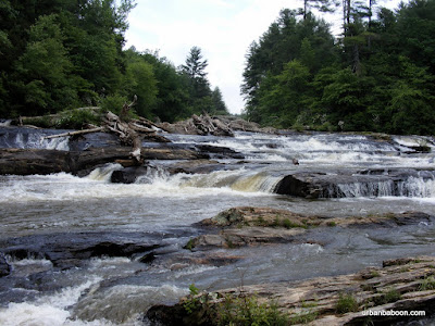 |
| From Edge of the World Rapids |
As the days begin to heat up, I often get asked, “What can a hiker do about the heat?” To me, the answer is actually quite simple: get North, get up and get wet. It is cooler North of Atlanta, higher in the mountains, and if there a nice place to stick your feet (or possibly more) in the water, all the better. One of the better places I know that satisfies these needs for the warm weather Georgia Hiker sits about 12 miles West of the North 400 outlet malls outside of Dawsonville, home of the Edge of the World Rapids and the Amicalola River Trail (approx. 1.5 hours from Atlanta).
One drawback to going to where the cool water is the higher foot traffic it attracts. This takes a bit away from my desire for solitude but the trade off in many cases is worth it. And this trail, once you leave the water becomes quite serene. Although most of the attraction is the water itself.
The rapids are, however, the star of the show and we found it quite easy to spend better than an hour there watching the kids and dogs play, and the kayakers running the rapids. So much so that you may be tempted to stop there for the day. The “Edge of the World” rapids are designated a Class IV , which makes for a nice challenge for the waterborne adventurer and some entertaining viewing for the land based passerby. You can also walk out on the rocks a bit and get in the water if you like (The waters not deep as I can attest because I accidentally fell in camera and all…which is my apology for no pix for much of the trail, I had to let it dry before it would turn back on). There are also stone ruins of the old bridge supports that used to cross the Amicalola.
The path is a loop with a bunch of zigs and zags and runs about 3 miles, which begins and ends at the parking lot off Highway 53. Once you get past the rapids, which dominate the first half mile of your trip, there are a few other things to see: Some vista views of the Southern Blue Ridge Mountains, a marker for a historical bootleggers still tucked in the undergrowth, and a picnic table dedicated to a boy scout, Jason Funk, an Eagle Scout from Cumming Georgia who worked on the trail and unfortunately died at 16 in 1991. There is a climb of about 400 feet in elevation that adds significantly to the aerobic benefit of your sojourn which leads to the better vista views.
So if you a looking to get away, get North, get up, and get wet, the Amicalola River trail is actually the first place I think of to answer the call. Its got a little bit of everything; some pretty water; some history; some some peace and quiet; and enough physical challenge to make your day memorable.
Trail Essentials
Approximate Time: 1.5-2 hours
Approximate Distance: 3 miles
Trail Surface: boardwalk, stairs, mostly compact soil
Features: Riverside Walk, Rushing Whitewater, Vista Views
Overall Rating: B+
Scenic Quality: A-
Athleticism: B
Solitude: B
Value: B+
Parking: Free
Hours of Operation: Any
Facilities: None
Maps: here
County: Dawson
No comments:
Post a Comment