 |
| From Fort Yargo |
Just a quick 11 mille drive out 316 toward Athens, there is a much overlooked State Park called Fort Yargo . I say overlooked because I think I’ve read just about every book about hiking in Georgia and this one is never mentioned except for in books that are trying to be comprehensive like Hiking Georgia. It’s never up for best walks or top places. As a matter of personal disclosure, I never even thought about going there until a couple of weekends ago, when other life events cut short my daylight hours and we settled on going there. And, maybe because my expectations were low, I was pleasantly surprised.

It’s probably not mentioned because the other activities at the park overshadow the 12 miles of hiking trails. First and probably foremost is that this is a Mountain Bikers haven, with 18 miles of trails that made me wish I had brought my bike (Trail Map Here ). Its also got a nice lake with tales told of great fishing, boating, and a beach area with public swimming, in addition to the picnicking and camping areas. But if you are looking for a nice walk in the woods and around a lake, there is great value here, and it seems to be very pet friendly.

Now there’s something a bit confusing about this place. First there are two entrances, the southernmost at McDaniel Road off 81 (map) has parking ($3, Feb 2009) near a bridge that breaks off into two separate trails, the Dam trail to the left (leading to the Dam) and the Old Fort Trail to the right. Both are out and backs and relatively short (Old Fort 1.2 miles round trip, Dam trail 2.2 mi). The confusing part is that the Old Fort is not on the Old Fort Trail, but takes you to where the Old Fort may have been (the exact location is unclear), there are some small ruins of some sort of Rock Wall or Foundation, but they are not two impressive. But you do get some peace and quiet in tranquil surroundings, some nice lake views, and in parts you can enjoy watching the mountain bikers do their thing. There is another longer trail which runs the shoreline, all other trails seems to be for the bicyclists.
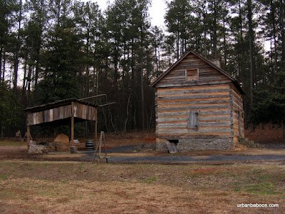
Now if you want to see the Old Fort , you need either to walk North along the shore line (about 2.5 miles) or drive to the second and main entrance on Broad Street, you then take a quick right cross a bridge and park not 75 feet from the cabin (map). The cabin is picturesque and was built back in 1792 , it looks a bit restored, but makes for nice photos right on the lake. There is a group that does re-enactment and living history stuff (their next event is March 21st, basically every third weekend) I should also mention that there is a Photography Contest currently going on now with submission deadline being June 15th.

Another confusing thing about this place is the trail map located at the main entrance. My two friends and I stared at this thing for about 15 minutes trying to figure out where the Old Cabin was. We had the darnedest time just trying to determine where we where based on landmarks we had seen. It wasn’t until we figure out that for some reason the map is drawn with South being up. Now that’s outside the box thinking, of which I do not approve. We were literally 500 yards from the Old Fort, it took longer to figure out how to get there than to get there.

That being said, if you are looking for a nice day out that expends only marginal effort with less than a hour drive and a very easy pathway, or if you want to get on your bike, this place serves this purpose nicely. Is it a must see or must do? Maybe not, hence the lack of inclusion in most literature. But considering its strengths, it is a great value.

Trail Essentials
Approximate Time: 1-2 hours (Fort and Dam Trails)
Approximate Distance: 3.4 miles
Trail Surface: mostly compact soil, some red clay, bridges
Features: Lake View, minor ruins, historic Cabin, views of people boating, biking, and fishing.
Overall Rating: B-*
Scenic Quality: B
Athleticism: C
Solitude: C
Value: A
Parking: $3
Hours of Operation: 7am to 10pm
Facilities: Throughout
Maps: At the Main Entrance, check the bike map above
County: Barrow
*this is a rating of the hiking trails, not a rating of the park, which seems to have every amenity
No comments:
Post a Comment