People have been telling me for months, you “gotta go to Sweetwater Park.” And I’ve been putting it off because I’ve learned that nothing can live up to that much hype. (Also, since its only about 15 minutes outside the city, near Lithia Springs, I’d thought I’d save it for a weekend when I had little time to spare.) Well, I went and I can honestly say that I hadn’t had as much fun hiking in a very long time.

The trail (map here) has almost everything I want out of a good hike. A little history, something beautiful to see. It’s a little lacking in the athleticism of the trail meaning this is a good hike to take kids along, or if your just starting out or don’t get out much.

What it lacks in getting your heart to race due to physicality, it does another way. The Creek itself is littered with Thousands of tiny rocks (Much more extensive than the Palisades) that you can walk (and sometimes jump) across for at least a mile. My friend and I stayed out on the water jumping rock to rock for over an hour. This is why this trip was so enjoyable.
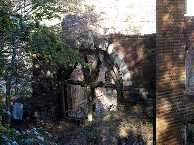
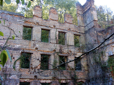
But wait there’s more: Sweetwater Creek is home to the ruins of the lost city of New Manchester. At its peak, the town boasted 500+ residents and was home to the New Manchester Manufacturing Company. The Factory was five stories high (Tallest building in the area at that time) and housed a 50,000 pound waterwheel to power the production. Much like the Roswell Mill, the Company had many orders to supply the Confederates during the Civil War and, much like Roswell, it became a target for General Sherman. (And much like Roswell, many of its women and children were taken away). All that remains is the remnants of the Factory, which stands as a centerpiece to the park.

A short distance after the ruins, you will come to a waterfalls area. The falls are short, and with the lack of water we are getting they are nothing spectacular. The cool thing is, with the rocks on the water, you can walk right up to it. It is still a picturesque sight (I took way more photos than I posted here, feel free to click into any of the photos to see the complete gallery)

Now from here you can double back, which will put your adventure at about 3-3.5 miles. Or you can continue on through the wildlife trail back to the trail head. This section is moderately strenuous and will cap the hike out at about 5.5 miles.
So if you here folks talk about Sweetwater as a great place to go, they are probably right. You can find a list of upcoming events at the park here, courtesy of the Friends of Sweetwater Creek.
Trail Essentials
Approximate Time: 4 hours (2.5 if you go to the falls and back)
Approximate Distance: 5.5 miles
Trail Surface: Compact Soil, Rocks
Features: Ruins, River Views, Small Waterfalls, River Rocks
Overall Rating: A-
Scenic Quality: A
Athleticism: C (B- if you go the full 5.5 distance)
Solitude: B
Value: A
Parking: $3 (Nov 2007)
Hours of Operation: Open Year Round, Sunlight Hours
Facilities: None
Maps: Posted at Trailhead, Maps available, or Trail Map (Trails are clearly blazed)
County: Douglas County
Thanks for reminding e of this. I did it a couple of times in the nineties, but haven't been back since moving closer to Stone Mountain. I'll definitely hit this one again.
ReplyDeleteI love the Sweetwater Ruins. When I went back in June, they had blocked them off, and I had to climb over the creek and up some rocks to get into them...were you able to get into the mill easily?
ReplyDelete