Best Hike I waited too long to write about. Tweet Map
When I go hiking, more often than not, I am very goal orientated. I want to climb this mountain, or see this waterfall, or whatever. I realize that there are some truly great hiking trails that don’t have some sort of ultimate goal. Places where hiking is wonderful on its own terms: you get outside into nature, you stretch your legs, and get your heart pumping. The strange thing about these types of trails is that I don’t rush back and feel compelled to write about them right away. This particular trail I hiked for the first time about 5 years ago, and probably walked along its paths better than two dozen times. And I have written extensively about it surrounding home: Stone Mountain Park, but until today I have never told the story of the fantastic nearby walking trail: Cherokee Trail.

This trail has several names. Officially, it is known as the Cherokee Trail on the maps you get at the gate. But it’s often called the Stone Mountain Loop Trail or the Stone Mountain National Recreation Trail. Any way you slice it, it is one of the finest trails in the Atlanta Area. Boys Scouts can even earn a merit badge for completing it. If you search the internet, you will see it listed sometimes as 5 miles, sometimes as 5.5 miles, and sometimes as 6 miles. To clear this up, my belief is that the true white blazed Cherokee Trail is 5 miles long. However, many folks walk a longer loop, which keeps the trail easy avoiding any part of the mountain, but lengthens the stroll to 6 miles. If you enter via the free parking at the Stone Mountain Visitor Center you can start the trail on the connecting trail in question. However, my personal recommendation on how to do the trail is the 5.5 mile way.

Start at the Stone Mountain Walk up trail and walk up the mountain as if you are heading to the top. After walking about ¼ mile, keep your eyes open for two stone markers noting the Cherokee Trail. You can turn right or left here, I prefer right taking the trail in a counterclockwise direction. First you will get some very different views of the mountain as you descend: Rocky, Desolate, and Beautiful. There’s a sign here saying that this might be dangerous when wet and I assure you this is true. Follow the white blaze into the woods below. The bulk of the trail except for the mountain part gives pretty good tree cover making this walk quite doable even in the hottest months. You will meet up with the connecting trail shortly. Those who do 6 mile version tend to do it for those reasons: keeping the difficulty down and staying out of the sun.

The first marker you encounter is known as the old homestead, which is really simply the remains of an old chimney. You will continue out of the forest, across the road by the playground. At the end of the playground there is a nice little pond to look at. You then continue to the lake. The lakeside walk gives some very nice views of the mountain as well as Lake Venable itself. After crossing a bridge, your time with the lake will be over, and soon you will encounter Stone Mountain Covered Bridge, first at a distance on the water, and then at a place where it can be crossed. I normally cross the bridge knowing full well that it’s off the trail. Being just shy of the halfway point around, it makes a good quick break spot.

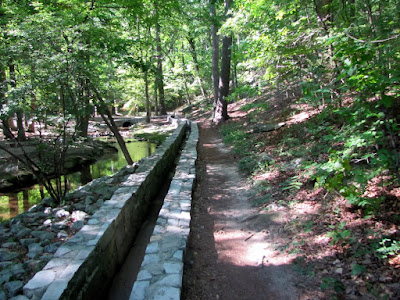
Back on the Trail, the next feature is the Old Grist Mill, which was moved here from the Elijay area back in the 60’s. If you like the sound of moving water, this part of the trail provides it. You follow the granite runway along a pretty creek. You cross street again and head toward the attractions areas. In this part of the woods, there’s some kind of Garden planted out there complete with a dedication marker, but I have never seen anything planted there. You then will come out of the woods at the main field where the grand Confederate Memorial sculpture can be seen in close proximity. You will then continue back into the woods for the final leg, which includes the walk back up the mountain to the point where it intercepts the walk up trail This part is pretty, serene, and difficult; but worth the effort to get your merit badge.
This is my preferred walking route as you get to nice uphill climbs at the beginning and the very end to really get your heart pumping. Some might add hiking to the top, which would add 40 minutes, 2 miles, and significant difficulty to your sojourn. If combine the two trails, you might just have the very best hike in the Greater Atlanta Area. The only drawback is the $10 parking fee. It has all the other key factors I look for: good exercise, pleasant surroundings to view, moments of tranquility, a sense of accomplishment, and only 30 minutes from downtown Atlanta.

Trail Essentials
Approximate Time: 2-2½ hours
Approximate Distance: 5.5 miles
Trail Surface: Stone, Compact Soil
Features: Mountain View, Lakeside Walk, Ruins, Mill, Covered Bridge, Huge Bas Relief
Overall Rating: A
Scenic Quality: A
Athleticism: A
Solitude: A
Value: A
Parking: $10
Hours of Operation: The Trail doesn’t really close
Facilities: At Attractions area, at Walk Up Trail
Maps: Hiking Map on this Page
County: DeKalb
 |
| From Stone Mountain Cherokee Trail |
When I go hiking, more often than not, I am very goal orientated. I want to climb this mountain, or see this waterfall, or whatever. I realize that there are some truly great hiking trails that don’t have some sort of ultimate goal. Places where hiking is wonderful on its own terms: you get outside into nature, you stretch your legs, and get your heart pumping. The strange thing about these types of trails is that I don’t rush back and feel compelled to write about them right away. This particular trail I hiked for the first time about 5 years ago, and probably walked along its paths better than two dozen times. And I have written extensively about it surrounding home: Stone Mountain Park, but until today I have never told the story of the fantastic nearby walking trail: Cherokee Trail.
This trail has several names. Officially, it is known as the Cherokee Trail on the maps you get at the gate. But it’s often called the Stone Mountain Loop Trail or the Stone Mountain National Recreation Trail. Any way you slice it, it is one of the finest trails in the Atlanta Area. Boys Scouts can even earn a merit badge for completing it. If you search the internet, you will see it listed sometimes as 5 miles, sometimes as 5.5 miles, and sometimes as 6 miles. To clear this up, my belief is that the true white blazed Cherokee Trail is 5 miles long. However, many folks walk a longer loop, which keeps the trail easy avoiding any part of the mountain, but lengthens the stroll to 6 miles. If you enter via the free parking at the Stone Mountain Visitor Center you can start the trail on the connecting trail in question. However, my personal recommendation on how to do the trail is the 5.5 mile way.
Start at the Stone Mountain Walk up trail and walk up the mountain as if you are heading to the top. After walking about ¼ mile, keep your eyes open for two stone markers noting the Cherokee Trail. You can turn right or left here, I prefer right taking the trail in a counterclockwise direction. First you will get some very different views of the mountain as you descend: Rocky, Desolate, and Beautiful. There’s a sign here saying that this might be dangerous when wet and I assure you this is true. Follow the white blaze into the woods below. The bulk of the trail except for the mountain part gives pretty good tree cover making this walk quite doable even in the hottest months. You will meet up with the connecting trail shortly. Those who do 6 mile version tend to do it for those reasons: keeping the difficulty down and staying out of the sun.
The first marker you encounter is known as the old homestead, which is really simply the remains of an old chimney. You will continue out of the forest, across the road by the playground. At the end of the playground there is a nice little pond to look at. You then continue to the lake. The lakeside walk gives some very nice views of the mountain as well as Lake Venable itself. After crossing a bridge, your time with the lake will be over, and soon you will encounter Stone Mountain Covered Bridge, first at a distance on the water, and then at a place where it can be crossed. I normally cross the bridge knowing full well that it’s off the trail. Being just shy of the halfway point around, it makes a good quick break spot.
Back on the Trail, the next feature is the Old Grist Mill, which was moved here from the Elijay area back in the 60’s. If you like the sound of moving water, this part of the trail provides it. You follow the granite runway along a pretty creek. You cross street again and head toward the attractions areas. In this part of the woods, there’s some kind of Garden planted out there complete with a dedication marker, but I have never seen anything planted there. You then will come out of the woods at the main field where the grand Confederate Memorial sculpture can be seen in close proximity. You will then continue back into the woods for the final leg, which includes the walk back up the mountain to the point where it intercepts the walk up trail This part is pretty, serene, and difficult; but worth the effort to get your merit badge.
This is my preferred walking route as you get to nice uphill climbs at the beginning and the very end to really get your heart pumping. Some might add hiking to the top, which would add 40 minutes, 2 miles, and significant difficulty to your sojourn. If combine the two trails, you might just have the very best hike in the Greater Atlanta Area. The only drawback is the $10 parking fee. It has all the other key factors I look for: good exercise, pleasant surroundings to view, moments of tranquility, a sense of accomplishment, and only 30 minutes from downtown Atlanta.
Trail Essentials
Approximate Time: 2-2½ hours
Approximate Distance: 5.5 miles
Trail Surface: Stone, Compact Soil
Features: Mountain View, Lakeside Walk, Ruins, Mill, Covered Bridge, Huge Bas Relief
Overall Rating: A
Scenic Quality: A
Athleticism: A
Solitude: A
Value: A
Parking: $10
Hours of Operation: The Trail doesn’t really close
Facilities: At Attractions area, at Walk Up Trail
Maps: Hiking Map on this Page
County: DeKalb
No comments:
Post a Comment