HOW NOT TO HIKE...map
This story needs to be told. It’s a story of poor preparation. We are instructed to carefully prepare and we don’t learn until the mistake teaches us an invaluable lesson. Its also the story of my first time on the Appalachian Trail. It also a story of some really nice folks you can meet away from the city. And then of course there’s plenty of pictures.
I don’t often go to the woods alone. On this occasion, I was going with two really close friends, one male and one female. The female has been on many expeditions with me, but none of us are super experienced hikers.
The other person wanted to go up to Helen, Georgia and get a beer. I order to unite our two passions, I decided that I would like to climb up the 7th Highest Mountain in the state of Georgia, just outside of Helen, Tray Mountain .
.
I downloaded and drew up a detailed plan. We were going to Andrews Cove Recreational Area, make the 2.5 mile hike along the river , reach the AT, turn right and head two miles up the mountain to the top of Tray Mountain. It should take us about 3-4 hours and we could be in Helen, Georgia in front of a Pint of Beer by 5pm.
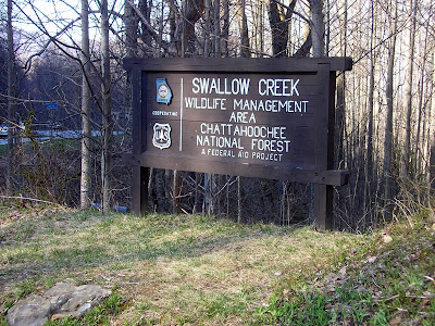
Well, that’s where we went wrong. Andrews Cove was closed. Not to be put off, we continued hunting around for a different approach. I wanted to get closer to the Mountain, but we found the Shallow Creek Access point a few miles up 75. We were climbing the 3600 foot Rocky Mountain, instead of the 4300 foot Tray Mountain, but that was good enough for us.
So we entered the toughest expedition we have ever gone on, without a map, without a flashlight, without enough water. I forgot to take an initial compass reading and I was the only one with a compass. We’ll it was fun, exhilarating, breathtaking, and challenging. And in the end, we got pretty lost. We walked at least 8 Miles that day.
That being said there are two things that must be noted. One, the Appalachian Trail is gorgeous and I understand why people are enthralled with it. I will someday do, at least, a multiple day portion of it. Second, is how nice the people in White County, who came to our rescue were.
My one friend made the mistake of wearing new boots on the hike. By about mile six, when we moved from being lost in the woods to being lost on a lonely gravel road, his feet were killing him. We sat to contemplate our situation and a couple drove up, helped us get our bearings, and actually drove him back to our car. There was no way the car could fit three. My other friend and I walked a couple more miles along that road, seemingly getting nowhere, when we stumbled across another couple in their car. We looked at their GPS system and thought we were further away than we thought. This couple made room for us and drove us back to our car.

Well, the story doesn’t end there. Friend one couldn’t come get us because, apparently, I left something on in the car and the battery died. So when we arrived, we saw him just sitting there.
We were now stranded by our car, which was a little better than before.
We managed to flag down another car to get Jumper Cables, and another smaller car with another couple in it to get a battery close enough to make the jump. One of the through hikers actually helped with the jumping. The three of us are very thankful to the Seven Strangers that put themselves out helping us today.
The person who inspired me to start hiking told me, “Nothing bad ever happens on the Mountain, everything bad always happens down there.” He’s right there is a lot of good on the mountain.
Oh yeah, Preparation is very important.
TRAIL ESSENTIALS
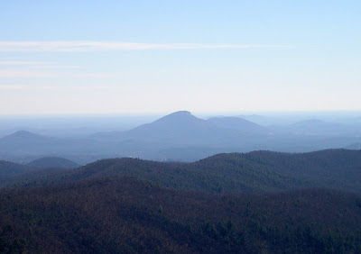
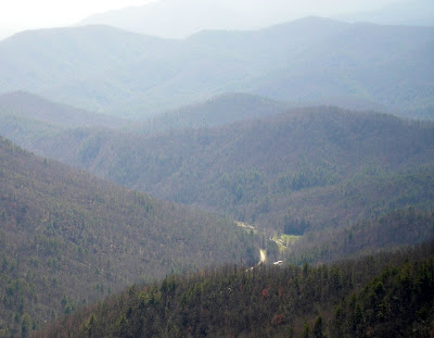
Creeks, Cascades, Tremendous Panoramic Views.
Difficulty High.
No real details, but some nice pictures.