Leo Frank Lynching Site

LYNCHING IN MARIETTA MAP

From Leo Frank Site


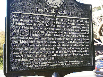
A little over a month ago, on March 7, 2008, a new Historical Marker was erected in Marietta. It was placed it front of the 1200 Roswell Road Building, under the shadow of I-75, at Frey’s Gin and Roswell Road. It stands a few hundred yards in front of the Kmart and just a couple of blocks from the famous Big Chicken. It commemorates one of the most infamous and intriguing moments in History Greater Atlanta has to offer, representing the end of one life, so intertwined with the end of another. It marks the site in which Leo Frank, convicted, commuted, and (much) later pardoned murderer of Little Mary Phagan.


Now, I’m going to try to avoid taking sides in the issue of Leo Frank’s Guilt or Innocence. My leanings toward Catholic doctrine and Classic Liberalism makes me feel that any use of the Death Penalty is wrong at its core. That is the part of the story this marker commemorates. Its not the murder site of Mary Phagan (Which was at the National Pencil Factory, where the Sam Nunn Federal Building (map) now stands). It not the site where Frank was imprisoned for the murder (a work farm near Milledgeville). But it is rather the site where a mob of what has been purported to be prominent Marietta Citizens brought Leo Frank to and hanged him from a tree.


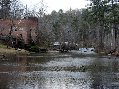
The point of this post is to show you where this piece of history is at, rather than tell the whole story. The history of the event is recounted quite well on About North Georgia, the New Georgia Encyclopedia, and various other sites. The point of this site is as always to show you where these things are and what they look like in case you wish to experience this piece of History first hand. I’ve included a photograph of Mary Phagan’s Gravesite, located a couple of miles away from the marker, at the Marietta Confederate Cemetery (MAP), where the mob, reportedly, got together and resolved to break the imprisoned Frank out of jail for purposes of ending his life).


A brief synopsis of what happened goes like this: On April 26, 1913, 13-year-old Mary Phagan went to the Pencil Factory to collect her wages from the manager Leo Frank. Early in the morning the next day, a night watchman, Newt Lee, discovered here battered and raped body in the factory. Leo Frank, the last person alive to see the girl, was later arrested, convicted, and sentenced to death on October 13 of that year. It was a momentous case because of the notoriety of the situation and the fact that it was the first Georgia case where a black man’s testimony (Jim Conley) led to the conviction of a white man (though many at the time held Jews, like Frank, as being non-white). Two years later, in June of 1915, Governor Slaton commuted the sentence from death because of irregularities in the trial system. On August 16, 1915, a mob grabbed Frank from a prison work farm near Milledgeville, transported him back to Marietta, where Little Mary was buried, and hanged him from a tree. There are photos of this here and here courtesy of Without Sanctuary, a site that catalogues (get this!!) postcards produced commemorating hangings. In 1982, Alonzo Mann, an office boy at the National Pencil Factory on his death bed stated that he saw the aforementioned Jim Conley at the site carrying the body of Mary Phagan on the night of the murder. Frank was pardoned without exonerating him of the crime in 1986 by the Georgia Pardons and Parole board. Although the Family of Mary Phagan maintains that Frank was convicted correctly. This is the super condensed version of the story, a great book on the subject is And the Dead Shall Rise: The Murder of Mary Phagan and the Lynching of Leo Frank, by Steve Oney (overview of book here).


The impact of the event was paramount in the revitalization of the KKK and led to the creation of the Anti-Defamation League. A dark moment in our collective history. Bad trials, Child Labor, Rape, Mob Justice, and a strangely joyous Lynching. Now if we can only get marker up for all our lynchings, maybe we’ll remember how precious actual civilized society is. There is a tree a few feet from the marker, where you can pause and imagine an ugly past and hope for a better future.

High Falls State Park

The Land of the Roasted Scalp Map

High falls
From High Falls St...


It seems to me that I spend most of my time to the North of the City of Atlanta. There are good reasons for it: I live in the Northeast Section of town so its closer, the North contains Georgia‘s share of the Appalachian Mountains, and I could go on. But the rest of the State has its charm, so I apologize for neglecting the Southeast.

The Falls of High Falls

A few weeks back (actually on the weekend of the great Atlanta Tornado), I had a Saturday off and a real need to get out into the outdoors. But rain and awful weather precluded my day in the Northern Mountains. So my little group went Southeast, out of the rain, and into a real gem of a State Park near Jackson, Georgia, known as High Falls State Park.

The Dam near the Old Mill

Situated only about 50 miles Southeast of Atlanta on I-75 (Just about an hour a few miles off exit 65) stands this great park with nearly everything I normally look for in one of my excursions. A little physical activity: the three trails here can keep you busy for about 4 miles. A little majestic natural beauty: the Towaliga River is probably the prettiest river I had never heard of before and it has a terrific waterfall. A little history: the park contains the remnants of the once prosperous city of High Falls. The park was a most pleasant surprise on a day when we were scrambling for a workable alternate option for our day.

High Falls Mill Ruins

The high point of the day is the High Falls waterfall (listed here). Just across the street (High Falls Road) from the park center is a 100 foot falls of the churning Towaliga river crossing a series of granite outcrops creating a dramatic and clearly picturesque natural delight. You can view the falls both from the right side (the short Falls trail at about .5 mile) or the left side (part of the longer nature trail at a little over two miles). I suggest you do the left side first as the nature trail can be followed a longer distance along the Towaliga River. Towaliga is a corruption of the Indian word “Ti-Laggi” which I am told means roasted scalp. The riverside portion of the trail is serene and worth the effort also. The trails I would rate as pretty easy, except for the climb up along the falls, which is a moderate climb that you must do twice (once on the right, once on the left).

Hiawassee Power Plant Ruins

If you like falling water, there additionally is a 35 foot high, 600 foot wide man-made dam on the park office side of the road that trail that is pretty in its own right. It was built in 1890 from granite taken right from the river below. This dam brought power to the former city of High Falls, which brings us to the History of the Area.

Tumblin' Towaliga River

Originally, it was Creek Indian territory and, according to legend, the sight of a great massacre sometime in the early 1800’s. Hence the bloody moniker. In the late 1800’s, it was settled as Unionville (the name was changed to High Falls). At High Falls peak (c. 1890), it was home to a grist mill, a shoe factory, a sawmill, a broom and mop factory, a power plant, a blacksmith shop, two separate furniture plants, a sawmill, and a blacksmith shop. All that remains is meager ruins of the grist mill, the power plant, and a portion of the Old Alabama Bridge. The bridge was one of the first roads in central and western Georgia (built in 1902). The grist mill ceased use in 1958, so I was surprised as to how little of it was left, but it was torn down by man, not by entropy. The Power Plant (built c. 1890), which was closed in 1960 is in much better shape and serves as the centerpiece of the Historic Trail. It is partially fenced off to preserve its status, but its clear by graffiti that the fence can be breached. It is amazing how a building left unattended just 50 years can fall to such disarray. But because it has been vacated such a relatively short time, it still remains a dramatic edifice hovering over a portion of the Towaliga River.

More of the Falls

Additionally, the park has several amenities that a typical family would like in a recreation area. A swimming pool, campsites, even boat rental (Attention my friend at Used Hardcovers, they also have pedal boat rental at $5 hour on the High Falls Lake). The Fishing is purported to be fantastic. This is a real gem of a park not too far from the town we call home. I went there as a fall back option, I want to be clear that this park can truly be a destination in itself in its own right.

Power Plant - River Side

We capped our day off by dining in nearby Juliette at the Whistlestop Cafe, movie home of Fried Green Tomatoes. The Jarrell Plantation is also nearby.

Old Alabama Bridge

Trail Essentials
Approximate Time: 1.5-2.5 hours
Approximate Distance: 3-4 miles
Trail Surface: Compact Soil, Stairs in places, Rocks
Features: Cascades, Riverside Walk, River Views, Waterfalls, Dam, Shoals, Historical Ruins
Overall Rating: B
Scenic Quality: B+
Athleticism: B-
Solitude: B
Value: B
Parking: $3 day use
Hours of Operation: Open Year Round, Sunlight Hours
Facilities: At park office
Maps: Available at Park Office
County: Monroe

ShareThis

Related Posts Plugin for WordPress, Blogger...