Sawnee Mountain

CHIEF SAWNEE’S SPIRIT LIVES HERE map
Chief Sawnee
From Sawnee Mountain


Now when I used to talk about the great nearby mountains, everyone knew I was speaking about Kennesaw Mountain and Stone Mountain : the (fraternal) twin sisters residing in Cobb and DeKalb County respectively. Both were about 1600-1700 feet in height and both had their separate but distinct charm. And I thought that was all you or I were going to get, at least until you got up to the Appalachians But I recently discovered I was wrong. Forsyth County has recently (2005) thrown their hat in the mix and opened up a new nature preserve surrounding a comparable mountain just outside of Cumming, Georgia by the name of Sawnee Mountain .
Indian Seat Trail
Sawnee Mountain looms over Cumming at a respectable 1963 feet. It is the mountain that you see when you pass Exit 17 on 400 with the satellite tower on it. And at only about 45 miles outside of Atlanta it serves as another option for those looking to get away from it all without going to far.
View from the Indian Seats
From Sawnee Mountain
The path is impeccably cleared and the footing is fantastic. The current trails run about 3.1 miles and can be covered in 2.5 to 3 hours. There are preparations being made to enhance the hiking here to over ten miles of trails. At that time, I believe this will be a significant destination for people with similar hobbies as mine. Now considering the height of the mountain, you might expect a difficult climb, but it really isn’t that difficult. Unfortunately, my GPS tracker failed and I can’t tell you the elevation gain, but based on experience, I would place this as a bit less intense that Kennesaw or Stone Mountain, even with the higher elevation (I would approximate a gain of about 450 feet). The trail guide indicates that the Indian Seats Trail to the summit is Easy to Moderate, though I would call it a solid Moderate for the casual hiker.
Atop Sawnee Mountain
Sawnee was apparently a well respected Cherokee Indian Chief. There are some rocks called “Indian Seats” that apparently he and the tribal leaders would sit in, surveying their people and land below. I don’t know much about him other than this cool story on Moonlit Road of him burying Indian Gold deep within the mountain and his restless spirit protecting it.
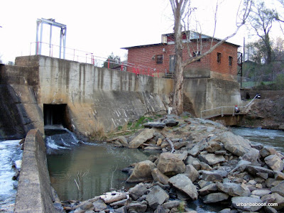
The truth is that there are two accessible gold mine shafts that you pass along your walk. But there were not protected by an Indian Spirit but rather by iron gates and padlocks. Nonetheless, they were an interesting diversion on the path.
Ga. Mountains in the distance
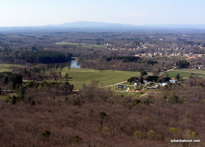
But the main attractions is the view from the top of the mountain. You can sit at the Indian seats or stand at a nearby observation deck to get a marvelous view of the low lying countryside against a backdrop of grand Georgia Mountains in the distance. The vista spans from Pine Log Mountain to the West to Brasstown Bald in the North East. It’s a view that is definitely worth hauling yourself up the mountain.
Abandoned Gold Mine Shaft
From Sawnee Mountain
The park looks to have all the other amenities too. They have a nice visitors center complete with information and comfy rocking chairs. Another part on the path has a tree house to keep the young ones entertained. And perhaps, most curiously, they have these tree top platforms that you can sign up to climb into (under supervision, of course) on the first and third Saturdays of every month.
Inside the Gold Mine
The Sawnee Mountain Preserve is enchanting and seems to be one of the more well thought out nature centers I have encountered. I think its overlooked at this point because of its relative newness, but given time, I believe it will be spoken of as the third great nearby Atlanta Mountain.
Tree Climbing Platform

Trail Essentials
Approximate Time: 2.5 to 3 hours
Approximate Distance: 3.2 miles
Trail Surface: Principally compact soil, small patches of rock footing
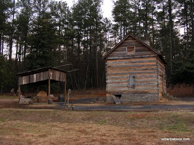
Features: Mountain view, views of Mountains, Abandoned Gold Mines.
Overall Rating: A-
Scenic Quality: A-
Athleticism: A-
Solitude: A-
Value: A
Parking: Free
Hours of Operation: Dawn to Dusk, Closed Major Holidays, Visitor Center has shorter hours
Facilities: At Visitor Center, also at secondary parking lot
Maps: At Visitor Center, here
County: Forsyth.

East Juliette Dam

The Ghost Town of East Juliette Map
The John Birch Dam
From John Birch Dam


Occasionally, if you’re lucky, you stumble upon a place of great wonder and beauty without really trying. You’ve done no research, you don’t really know what your looking for, but you find it nonetheless. That happened to me the last time I went to Juliette, Georgia .

East Juliette Gristmill Ruins

Now on a quiet day in Juliette, and most of them are, you can hear in the distance the roar of water. After loading up on Fried Green Tomatoes , we went off in search of what was making that noise, with visions of tremendous whitewater or an unknown waterfall dancing in our heads.

John Birch Dam from the Top

What we found, after crossing the Ocmulgee River on a bridge on Juliette Road into East Juliette , was a man made phenomena, but majestic nonetheless, which I found out later was called the John Birch Dam.
This dam must be over 100 feet long, though the fall can’t be more than 12 or 15 feet, and thus it creates a rush of water, an echoing of current, and an amazing sight to behold. There is even the remains of the East Juliette Gristmill on the Western shore.

close up of the dam’s falling waters

Now, there were conflicting signs posted, at least one said “No Trespassing,” but another said Boat Ramp this way, and there was parking. The parking is off a dirt path of Old River Road. We learned later that this is a frequently used water access point and the fishing is supposedly terrific. There was a path that leads you right to the gristmill and brings you within a few feet of the dam’s theatrics. There’s even a concrete slab you can carefully walk out onto to get a better view (its probably 40 or 50 feet long and about a foot wide, so I do mean carefully).

view from the concrete beam

I wouldn’t call this a hike, but it was a fun adventure. I would say it was hard exercise, but its not for the weak of body. But it was a beautiful spot in Georgia that I am pretty sure is almost always overlooked. Next time you are over Juliette way, take 30 minutes to enjoy the old grist mill and this fantastic panoramic water show.

wide view of the dam

Euharlee Covered Bridge

She Runs and Laughs Map

Euharlee Covered Bridge
From Euharlee Covered Bridge


In part four of my 17 part series., “Better know a Georgia Covered Bridge ,” I traveled a little over an hour Northwest of Atlanta to the town of Euharlee, Georgia , a town so happy its very name means “She laughs as she runs.” Now I’m not all that certain what she’s laughing at or running from, but what I found was a quaint little town near Cartersville, where they are building a park around the Euharlee Creek Covered Bridge .

inside the Bridge

This bridge sit’s a stones throw off Stilesboro Road, on Covered Bridge road, at spans a majestic 137 feet in length and better than 16 feet in width. It is on the National Register of Historic Places and part of the Covered Bridge Trail of Georgia. It is considered historic, probably because it was built by an contractor of African Descent, the son of Horace King , W.W. King (though some sources indicate that another man helped in the design and construction), and its age, being constructed 120 years ago. The bridge is constructed in the town lattice style and has interesting number marks and insignia still visible which gives it a quirky sort of “paint by numbers” feel.

Bridge across Euharlee Creek

This bridge was commissioned to be built in 1886 by Daniel Lowry, owner of Lowry’s Mill and most of the land around the area, after a more poorly constructed bridge collapsed killing one man (a Mr. Nelson), a mule, and a horse. The new bridge has yet to claim a life and serves as the centerpiece of what seems to be a new park endeavor for Euharlee. They even have a big festival celebration each Labor Day Weekend.

the Ruins from the Bridge

Three notes of interest about this site: first, the ruins of Lowry’s Mill remain a short walk away from the bridge and are fully accessible, and yes I do have a thing for ruins. Second, there seems to be a museum operated by the locals put in a nearby shed. There is an interesting story about that place written by a Kennesaw State student here . And finally a couple of blocks up the road is a Black Pioneer Cemetery filled with very “Blair Witch Project” looking unmarked stick cross grave markers. There’s purported to be better than 300 buried there. I mean no offense to anyone by saying that it looked creepy, but we hit this place just as night was falling and it gave me a disconcerting feeling (Should one feel comfortable in a Cemetery?).

Lowry’s Mill Ruins

There is more to see in the Bridge Area as they are restoring some other nearby old buildings. I look forward to one day seeing the completed project. It appears that the city of Euharlee knows how to preserve its culture, so I put this here as a suggestion that you take advantage of it.

Euharlee Creek beneath the Bridge

Fort Yargo

Yargo make me lose my mind…map

Lake View from the cabin ruins
From Fort Yargo


Just a quick 11 mille drive out 316 toward Athens, there is a much overlooked State Park called Fort Yargo . I say overlooked because I think I’ve read just about every book about hiking in Georgia and this one is never mentioned except for in books that are trying to be comprehensive like Hiking Georgia. It’s never up for best walks or top places. As a matter of personal disclosure, I never even thought about going there until a couple of weekends ago, when other life events cut short my daylight hours and we settled on going there. And, maybe because my expectations were low, I was pleasantly surprised.

on the lakeshore trail

It’s probably not mentioned because the other activities at the park overshadow the 12 miles of hiking trails. First and probably foremost is that this is a Mountain Bikers haven, with 18 miles of trails that made me wish I had brought my bike (Trail Map Here ). Its also got a nice lake with tales told of great fishing, boating, and a beach area with public swimming, in addition to the picnicking and camping areas. But if you are looking for a nice walk in the woods and around a lake, there is great value here, and it seems to be very pet friendly.

Biking the trails

Now there’s something a bit confusing about this place. First there are two entrances, the southernmost at McDaniel Road off 81 (map) has parking ($3, Feb 2009) near a bridge that breaks off into two separate trails, the Dam trail to the left (leading to the Dam) and the Old Fort Trail to the right. Both are out and backs and relatively short (Old Fort 1.2 miles round trip, Dam trail 2.2 mi). The confusing part is that the Old Fort is not on the Old Fort Trail, but takes you to where the Old Fort may have been (the exact location is unclear), there are some small ruins of some sort of Rock Wall or Foundation, but they are not two impressive. But you do get some peace and quiet in tranquil surroundings, some nice lake views, and in parts you can enjoy watching the mountain bikers do their thing. There is another longer trail which runs the shoreline, all other trails seems to be for the bicyclists.

the old fort

Now if you want to see the Old Fort , you need either to walk North along the shore line (about 2.5 miles) or drive to the second and main entrance on Broad Street, you then take a quick right cross a bridge and park not 75 feet from the cabin (map). The cabin is picturesque and was built back in 1792 , it looks a bit restored, but makes for nice photos right on the lake. There is a group that does re-enactment and living history stuff (their next event is March 21st, basically every third weekend) I should also mention that there is a Photography Contest currently going on now with submission deadline being June 15th.

inside the old fort

Another confusing thing about this place is the trail map located at the main entrance. My two friends and I stared at this thing for about 15 minutes trying to figure out where the Old Cabin was. We had the darnedest time just trying to determine where we where based on landmarks we had seen. It wasn’t until we figure out that for some reason the map is drawn with South being up. Now that’s outside the box thinking, of which I do not approve. We were literally 500 yards from the Old Fort, it took longer to figure out how to get there than to get there.

fort trail ruins

That being said, if you are looking for a nice day out that expends only marginal effort with less than a hour drive and a very easy pathway, or if you want to get on your bike, this place serves this purpose nicely. Is it a must see or must do? Maybe not, hence the lack of inclusion in most literature. But considering its strengths, it is a great value.

fishing from the bridge

Trail Essentials
Approximate Time: 1-2 hours (Fort and Dam Trails)
Approximate Distance: 3.4 miles
Trail Surface: mostly compact soil, some red clay, bridges
Features: Lake View, minor ruins, historic Cabin, views of people boating, biking, and fishing.

Overall Rating: B-*

Scenic Quality: B
Athleticism: C
Solitude: C
Value: A
Parking: $3
Hours of Operation: 7am to 10pm
Facilities: Throughout
Maps: At the Main Entrance, check the bike map above
County: Barrow
*this is a rating of the hiking trails, not a rating of the park, which seems to have every amenity

Guest Book


How is it that this page is consistently viewed 150 times a month 
and I only have a dozen (or so)
Sign ins....

Please feel free to drop me a note here saying whatever it is you want to say.

Encourage me, Discourage me, Praise or Rebuke me.


The idea that this thing is useful to someone is the fuel that keeps me going.
I know a bunch of you visit this page, please drop a note.

State of the Baboon 2009

Happy Birthday to me..
Happy Birthday dear Baboo-oon
Happy Birthday to me..
And There will be many more…(promise)

Last year when I posted my first State of the Baboon address, I was excited and proud and planned big things for the year to come. This year I am a bit less excited, more cautiously optimistic. Last year, we saw gas prices go through the roof and the start of the grand economic depression we are in and I will admit that these things got to me. It caused me to be less energetic, less inspired, less willing to travel.

So that is why I am cautiously optimistic and not bubbling over with pride. I wrote down that I wanted to get to 25000 visitors by my next birthday (and yes the man behind the Baboon turns 40 today), and I sit at 47500 visitors, nearly doubling my goal in spite of my diminished effort. I appreciate every single one of those hits, it tells me that this two year old hobby may have some real value to others, that its not in vain.

I also received some nice emails from different folks throughout the year. And I think I answered all of them but two (Sorry you two). They almost always make me happy. And a special thanks to the Atlanta Shutterbugs (they know who they are), who made me feel like a celebrity for a day or two.

I promise this site will continue and March 4 each year will be the jumping off point. I would post a bit this week but I am in Florida enjoying some Sun and Spring Training. This blog will be there each week to hopefully highlight something new and interesting. There will be some new additional directions, as outlined in my New Years Post. So I won’t go there now. I do plan on adding a link for support of the Baboon, not that I’m trying to get rich, my intent is that the information will always be free as Information should be, but if you want to be a pal and buy a coffee mug or something to defer the cost I hope there’s no problem with that (My financial goal is to make enough money at this so that I can deduct the costs of all my trips.)

Any way the State of the Baboon is hopeful, hopeful for the world, hopeful for this site, and hopeful that you might still come along on this ride with me. I promise I’ll do my best to post new interesting things each week, and I apologize in advance for the few times where I know I will fail in that attempt. After All, I am a lower level primate.

Cheers,
Doug Boyle
the urban baboon

ShareThis

Related Posts Plugin for WordPress, Blogger...