 |
| From Rocky Face |
Occasionally, we all like to challenge ourselves, a couple of years ago my brother came up to Atlanta and we set out to climb several difficult mountains in North Georgia. The hike for the last day was bumped primarily due to exhaustion and I never made it back. Billed as the most strenuous short hike in NW Georgia, I simply could never get my casual hiking friends to make the trip before last weekend. The trail is called the Disney Trail and it takes you to the summit of Rocky Face Mountain, and its situated under two hours Northwest of Atlanta off I-85 just outside Dalton, Georgia .

Now before I tell you about the difficulties of the trail, I want to tell you what’s so great about it. First, this climb achieves two of the three goals I have in hiking in spades. I look for exercise and this one truly gets your heart racing. I look for solitude, to get away from it all to reset my mind, and this was the first hike I’ve done where I saw no human being save my group the whole 2 ½ hours we were on it (and we set out up the trail about 1:30 pm on a Sunday). But it has more than that.

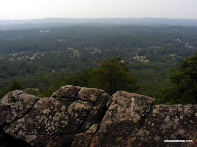
It has some very nice views from the top, which most mountains give as you can see in the pictures. We carried up our lunch and dined triumphantly at a point known as the Buzzard’s Roost. It has this one truly unique feature: a Civil war gravesite. The gravesite is of an English-born, Kentuckian who fought in the Civil War as part of a communications team by the name of George Disney . That’s why they call it the Disney trail. This was uncovered in 1912 by a group of Boy Scouts, who replaced the head stone then and who maintain the trail still to this day. Rocky Face was also the site of the Battle of Rocky Face , an early challenge to General Sherman on his campaign to Atlanta. I am always amazed to think that soldiers carried packs and artillery up mountains that I get winded on just carrying up lunch.

The trailhead is clearly marked and easy to find if you know the secret. You have to turn into the First Church of the Nazarene on Hwy 41, just a few minutes off the Interstate. At the back, by the Tifton Life Center there is ample parking and to very clear signs marking the trail’s start (I imagine parking may be an issue during Church events, please be courteous). The trail starts up with a straight ascent and the incline pretty much doesn't stop for 1.2 miles. The elevation gain is better than 800 feet, which places it about 133% of the challenge that Stone Mountain presents. There are very few switchbacks, and the ones that are placed are so short to the point of being virtually meaningless. Some kind folk placed a well needed bench at about the half way point. I make no bones about it, this one is difficult, one you shouldn’t be ashamed of taking a well needed and well deserved break during your trek. And unlike Stone Mountain , you won’t have to watch a 70 year old man walk by you, making you feel inferior. The summit is about 1580 feet above sea level, not the tallest of mountains, but beautiful nonetheless.

At the top, there is a good viewing place, known as Buzzards Roost, and directly behind that is the grave and marker for the remains of Confederate George Disney. If you walk on about ¼ more, there’s a better viewing place among the rocks on the ridge. My understanding is that the trail can be followed for a few miles (rumors say all the way to the NW GA trade center) but we didn’t go all that way. The one additional bad thing to report is that a member of my group was stung 4 times by a yellow jacket, marking our first significant injury on any of our trips. It reminds us of two things: first the importance of a good first aid kit, and second that the wilderness belongs to the nature that inhabits it.
In my research for this post, I noticed two interesting stories about Rocky Face that go beyond History. There is a rumor that there’s Gold in them hills , specifically Cherokee gold. Considering Georgia’s historical place in gold mining this could be believed but the stories talk about bars six feet long. It might be the Waterhouse Treasure , but who knows and we certainly didn’t find it. The second it that the region is watched by 3 foot tall elves, leprechauns, spirits or trolls (Read this stuff, it’s a hoot). Again I can confidently say, we met no one.

So if you are looking to challenge yourself, see a civil war grave, search for gold, or fight off leprechauns, the Disney trail up Rocky Face mountain has something for you.
Trail Essentials
Approximate Time: 2 hours
Approximate Distance: 2.4 miles
Trail Surface: compact soil, rocks
Features: Vista Views, Gravesite, Historical Significance, Athletic Challenge
Overall Rating: A
Scenic Quality: B+
Athleticism: A+
Solitude: A+
Value: A
Parking: Free in the Tifton Family Life Center Parking Lot
Hours of Operation: Virtually Anytime
Facilities: None
Maps: None, trail well marked
County: Whitfield
Now before I tell you about the difficulties of the trail, I want to tell you what’s so great about it. First, this climb achieves two of the three goals I have in hiking in spades. I look for exercise and this one truly gets your heart racing. I look for solitude, to get away from it all to reset my mind, and this was the first hike I’ve done where I saw no human being save my group the whole 2 ½ hours we were on it (and we set out up the trail about 1:30 pm on a Sunday). But it has more than that.
It has some very nice views from the top, which most mountains give as you can see in the pictures. We carried up our lunch and dined triumphantly at a point known as the Buzzard’s Roost. It has this one truly unique feature: a Civil war gravesite. The gravesite is of an English-born, Kentuckian who fought in the Civil War as part of a communications team by the name of George Disney . That’s why they call it the Disney trail. This was uncovered in 1912 by a group of Boy Scouts, who replaced the head stone then and who maintain the trail still to this day. Rocky Face was also the site of the Battle of Rocky Face , an early challenge to General Sherman on his campaign to Atlanta. I am always amazed to think that soldiers carried packs and artillery up mountains that I get winded on just carrying up lunch.
The trailhead is clearly marked and easy to find if you know the secret. You have to turn into the First Church of the Nazarene on Hwy 41, just a few minutes off the Interstate. At the back, by the Tifton Life Center there is ample parking and to very clear signs marking the trail’s start (I imagine parking may be an issue during Church events, please be courteous). The trail starts up with a straight ascent and the incline pretty much doesn't stop for 1.2 miles. The elevation gain is better than 800 feet, which places it about 133% of the challenge that Stone Mountain presents. There are very few switchbacks, and the ones that are placed are so short to the point of being virtually meaningless. Some kind folk placed a well needed bench at about the half way point. I make no bones about it, this one is difficult, one you shouldn’t be ashamed of taking a well needed and well deserved break during your trek. And unlike Stone Mountain , you won’t have to watch a 70 year old man walk by you, making you feel inferior. The summit is about 1580 feet above sea level, not the tallest of mountains, but beautiful nonetheless.
At the top, there is a good viewing place, known as Buzzards Roost, and directly behind that is the grave and marker for the remains of Confederate George Disney. If you walk on about ¼ more, there’s a better viewing place among the rocks on the ridge. My understanding is that the trail can be followed for a few miles (rumors say all the way to the NW GA trade center) but we didn’t go all that way. The one additional bad thing to report is that a member of my group was stung 4 times by a yellow jacket, marking our first significant injury on any of our trips. It reminds us of two things: first the importance of a good first aid kit, and second that the wilderness belongs to the nature that inhabits it.
 |
| From Rocky Face |
So if you are looking to challenge yourself, see a civil war grave, search for gold, or fight off leprechauns, the Disney trail up Rocky Face mountain has something for you.
Trail Essentials
Approximate Time: 2 hours
Approximate Distance: 2.4 miles
Trail Surface: compact soil, rocks
Features: Vista Views, Gravesite, Historical Significance, Athletic Challenge
Overall Rating: A
Scenic Quality: B+
Athleticism: A+
Solitude: A+
Value: A
Parking: Free in the Tifton Family Life Center Parking Lot
Hours of Operation: Virtually Anytime
Facilities: None
Maps: None, trail well marked
County: Whitfield


