Watson Mill Covered Bridge State Park

Better Know a Covered Bridge: Watson Mill  Map
Watson Mill Covered Bridge State Park
From WATSON MILL COVERED BRIDGE

Earlier this year, I traveled to see the State’s Longest Covered Bridge, which sits as the centerpiece for a very nice 1000 acre state park situated at about 2 hours West and North of Atlanta (about 45 minutes West of Athens) near Comer, Georgia. The park bears the name of the Bridge and is called Watson Mill Covered Bridge State Park.
Riverview of Watson Mill Covered Bridge

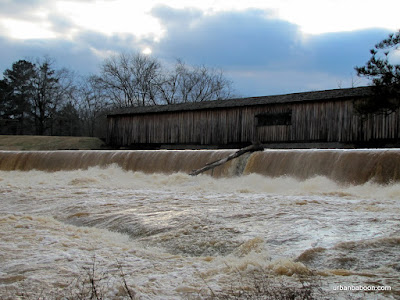
Now we came for the Bridge, a magnificent structure spanning 236 feet across the Broad River. It was built in 1885 by renowned bridge builder W.W. King in the town lattice style (A little History here ). It was built to replace an earlier bridge which washed out during one of the “freshets,” or flash flooding. I have read that the bridge is not in use, but you can drive across it and the road you are on will take you back toward Athens, so I think that information is incorrect.
Powerhouse Ruins

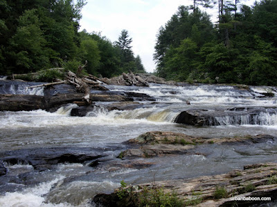
On the day we went, in February of 2010, we experienced one of these freshets. The water was raging under the bridge and over the dam about 15 feet away. The banks of the broad river widened greatly covering the rocks and the land trees were growing from over a much greater span than the long bridge. It’s my understanding that the area is very popular for playing on the rocks and swimming, but there would be none of that this day.
Raging Water under the Bridge

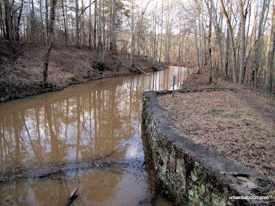
To our surprise, we found two very nice hiking trails on the both sides of the river. Both gave exceptional views of the river and bridge, but the North side was more interesting. Aside from a couple of well placed viewing platforms, they have some nice ruins of the old powerhouse. You get to walk a short two mile loop along the stream and back along the raceway (or vice versa). The South side loop runs about 2.5 miles beginning on the shores of the Broad river but then circling into the woods in what is billed as a nature trail, which could also be a fairly simple bike path.
Broad River's Raging waters

Some of the covered bridges I have visited in the past, were simply little stop bys on the way to or back from another destination. The Watson Mill Bridge and surrounding state park can stand as a destination in itself: A nice 4.5 mile walk; a pretty river and historic bridge, and the possibility of a quick dip in the river along the rocks
Along the raceway

Trail Essentials
Approximate Time: 2-2.5 hours
Approximate Distance: 4.5 miles
Trail Surface: Compact Soil, Rocks, some wooden stairs
Features: Riverside View, historic Bridge, Ruins
Overall Rating:
Scenic Quality: A
Athleticism: B
Solitude: B
Value: A
Parking: $5 (standard state park fees-2010)
Hours of Operation: Daylight hours
Facilities: At the welcome center
Maps: North side (not needed), South Side (Blazed)
County: Madison County

Edge of the World Rapids

Amicalola River Trail Map
Edge
From Edge of the World Rapids


As the days begin to heat up, I often get asked, “What can a hiker do about the heat?” To me, the answer is actually quite simple: get North, get up and get wet. It is cooler North of Atlanta, higher in the mountains, and if there a nice place to stick your feet (or possibly more) in the water, all the better. One of the better places I know that satisfies these needs for the warm weather Georgia Hiker sits about 12 miles West of the North 400 outlet malls outside of Dawsonville, home of the Edge of the World Rapids and the Amicalola River Trail (approx. 1.5 hours from Atlanta).
Amicalola

One drawback to going to where the cool water is the higher foot traffic it attracts. This takes a bit away from my desire for solitude but the trade off in many cases is worth it. And this trail, once you leave the water becomes quite serene. Although most of the attraction is the water itself.
bridge

The rapids are, however, the star of the show and we found it quite easy to spend better than an hour there watching the kids and dogs play, and the kayakers running the rapids. So much so that you may be tempted to stop there for the day. The “Edge of the World” rapids are designated a Class IV , which makes for a nice challenge for the waterborne adventurer and some entertaining viewing for the land based passerby. You can also walk out on the rocks a bit and get in the water if you like (The waters not deep as I can attest because I accidentally fell in camera and all…which is my apology for no pix for much of the trail, I had to let it dry before it would turn back on). There are also stone ruins of the old bridge supports that used to cross the Amicalola.
Kayaker

The path is a loop with a bunch of zigs and zags and runs about 3 miles, which begins and ends at the parking lot off Highway 53. Once you get past the rapids, which dominate the first half mile of your trip, there are a few other things to see: Some vista views of the Southern Blue Ridge Mountains, a marker for a historical bootleggers still tucked in the undergrowth, and a picnic table dedicated to a boy scout, Jason Funk, an Eagle Scout from Cumming Georgia who worked on the trail and unfortunately died at 16 in 1991. There is a climb of about 400 feet in elevation that adds significantly to the aerobic benefit of your sojourn which leads to the better vista views.
sitting

So if you a looking to get away, get North, get up, and get wet, the Amicalola River trail is actually the first place I think of to answer the call. Its got a little bit of everything; some pretty water; some history; some some peace and quiet; and enough physical challenge to make your day memorable.
Edge

Trail Essentials
Approximate Time: 1.5-2 hours
Approximate Distance: 3 miles
Trail Surface: boardwalk, stairs, mostly compact soil
Features: Riverside Walk, Rushing Whitewater, Vista Views
Overall Rating: B+
Scenic Quality: A-
Athleticism: B
Solitude: B
Value: B+
Parking: Free
Hours of Operation: Any
Facilities: None
Maps: here
County: Dawson

Panola Mountain

THE MOST NATURAL AND UNDISTURBED MONADNOCK OF EXPOSED GRANITIC ROCK IN THE PIEDMONT BIOPHYSIOGRAPHIC PROVINCE. Map

From Panola Mountain


I just love the above sentence.  I usually make up what I think are catchy little titles to my posts, but what could possibly draw a reader in better than that sentence.  To be honest, I had to look up one of the words, only because I’ve come across monadnock previously.  But apparently, we Atlantans live 30 minutes west of “the most natural and undisturbed monadnock of exposed granitic rock in the Piedmont biophysiographic province.”  And I believe its something you should know about and see, so I’m going to tell you the story of hiking Panola Mountain and Panola Mountain State Park .


Panola Mountain is a National Natural Landmark and the centerpiece of the Georgia State park of the same name.  It is a granite mountain similar to Stone Mountain or Arabia Mountain .  If Arabia Mountain is Stone Mountain’s quieter brother, Panola Mountain is the third child locked in his room to keep him from harm.  As a matter of fact, there are no public trails to its summit.  The public trails at the park are only 2 miles long and take you along the base of the mountain (there’s also a fitness trail at about a mile).  So I put this trip off for a long time because I didn’t want to drive a hour for a two mile walk (I live North of the city).   So I made my pilgrimage on the way back from another state park further East.


And I got lucky.  I had heard that they had ranger led guided tours that scale the summit, but they were always at 10 am on Saturdays, which is very difficult for me to make (I work a majority of Saturdays, thus the focus of this site on Sunday daytrips).  The plan was to stop and do the self guided trail along the base of the mountain, but they have started something new: what they call the Mountain Top Owl Prowl , which takes you on a guided trek up the mountain as the sun is setting.  Normally you have to make reservations (call 770-389-7801) and they limit the group to 25, but the nice guide Jeff expanded the group to 27 to make room for the baboon and one companion.


The reason the mountain is off limits to untrained and unescorted personnel is to keep the mountain natural and undisturbed.  It is home to many species of lichen, moss, diamorphs, and herbs that just don’t exist anyplace else.  Some are endangered, some are endemic to granite outcrops, and some are just plain rare.  So even though you are climbing to the 940 foot peak (the elevation gain is only about 250 feet), the star of the show is literally at your feet.  You walk near and, in some unfortunate cases, over a patchwork quilt of yellows, reds, greens, greys and blacks which is visually quite stunning.  But you do your best not to walk on them, if you crush them they are dead and will not be back for 800 or so years (Try growing a plant on a rock and see how long it takes).  The colors come from such species as Vigueria Porteri, Minuartia Uniflora, and the most famous red Diamorphia Smallii, just to name a few.  You will walk up single file and the guide will tell you to do your best to walk in the preceding persons footsteps, and tell you which colors are better to walk on if faced with no other choice, but I forget the order.  Eventually, there will be a path made by the added hikers, and I guess the added attention to the park will help preservation in the long run.


You will also get to see the sun set over Atlanta, which is always nice.  You may see some wildlife like deer or owls, but we did not.  The granite rock in and of itself is quite picturesque.  There are also some old cabins owned by the Yarborough Family (who previously owned the land) and a very serene little pond.  In additon to the owl crawl (1st Saturday of the month at 8pm), and the Every Saturday 10 am hike, but they have also added a Sunday hike (2nd Sunday of each month at 2pm), so the opportunity to visit has expanded to 150 people a month and accommodates folks of differing schedules.  The owl crawl is probably only 1.5 miles as you drive to a different parking area to save on time and light, but the other two go a full 3.5 miles.  There is a cost involved, the hike costs $7 and there is a $5 parking fee as all Georgia Parks have. [All fees and times are current for April 2010, check their Website ] And remember reservations are required.


I hope I didn’t scare you off with the rules and fees, because it is truly a unique experience I am very grateful for having done.  You see the most beautiful things that would make you scrunch your nose in disgust, if you saw it on a loaf of bread.  You scale another of Georgia’s great peaks.  And the money supports the great natural treasure of Panola Mountain and our great resource of Georgia’s State Parks.


Trail Essentials
Approximate Time: 1-1.5 hours (Night Owl Crawl)
Approximate Distance: 1.5 miles
Trail Surface: compact soil, granite, small life forms
Features:  rare species of flora, mountain peak, panoramic views
Overall Rating:
Scenic Quality: A+
Athleticism:  A-
Solitude: A+
Value: A
Parking: $5  
Hours of Operation: Special for hikes, see text
Facilities: At the visitor center
Maps: Guided tours none needed, at visitor center for self guided trail.
County: border of Henry and Rockdale County, near Stockbridge.

ShareThis

Related Posts Plugin for WordPress, Blogger...