 |
| From High Falls St... |
It seems to me that I spend most of my time to the North of the City of Atlanta. There are good reasons for it: I live in the Northeast Section of town so its closer, the North contains Georgia‘s share of the Appalachian Mountains, and I could go on. But the rest of the State has its charm, so I apologize for neglecting the Southeast.

A few weeks back (actually on the weekend of the great Atlanta Tornado), I had a Saturday off and a real need to get out into the outdoors. But rain and awful weather precluded my day in the Northern Mountains. So my little group went Southeast, out of the rain, and into a real gem of a State Park near Jackson, Georgia, known as High Falls State Park.

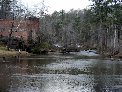
Situated only about 50 miles Southeast of Atlanta on I-75 (Just about an hour a few miles off exit 65) stands this great park with nearly everything I normally look for in one of my excursions. A little physical activity: the three trails here can keep you busy for about 4 miles. A little majestic natural beauty: the Towaliga River is probably the prettiest river I had never heard of before and it has a terrific waterfall. A little history: the park contains the remnants of the once prosperous city of High Falls. The park was a most pleasant surprise on a day when we were scrambling for a workable alternate option for our day.

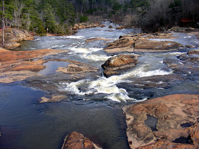
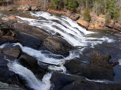
The high point of the day is the High Falls waterfall (listed here). Just across the street (High Falls Road) from the park center is a 100 foot falls of the churning Towaliga river crossing a series of granite outcrops creating a dramatic and clearly picturesque natural delight. You can view the falls both from the right side (the short Falls trail at about .5 mile) or the left side (part of the longer nature trail at a little over two miles). I suggest you do the left side first as the nature trail can be followed a longer distance along the Towaliga River. Towaliga is a corruption of the Indian word “Ti-Laggi” which I am told means roasted scalp. The riverside portion of the trail is serene and worth the effort also. The trails I would rate as pretty easy, except for the climb up along the falls, which is a moderate climb that you must do twice (once on the right, once on the left).
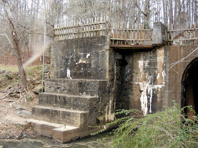
If you like falling water, there additionally is a 35 foot high, 600 foot wide man-made dam on the park office side of the road that trail that is pretty in its own right. It was built in 1890 from granite taken right from the river below. This dam brought power to the former city of High Falls, which brings us to the History of the Area.
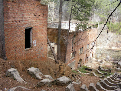
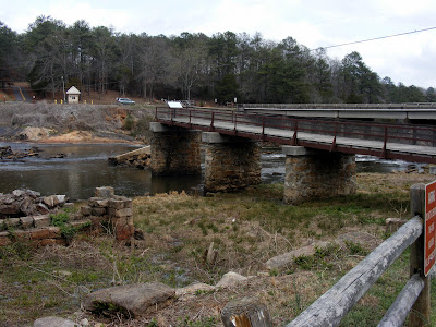
Originally, it was Creek Indian territory and, according to legend, the sight of a great massacre sometime in the early 1800’s. Hence the bloody moniker. In the late 1800’s, it was settled as Unionville (the name was changed to High Falls). At High Falls peak (c. 1890), it was home to a grist mill, a shoe factory, a sawmill, a broom and mop factory, a power plant, a blacksmith shop, two separate furniture plants, a sawmill, and a blacksmith shop. All that remains is meager ruins of the grist mill, the power plant, and a portion of the Old Alabama Bridge. The bridge was one of the first roads in central and western Georgia (built in 1902). The grist mill ceased use in 1958, so I was surprised as to how little of it was left, but it was torn down by man, not by entropy. The Power Plant (built c. 1890), which was closed in 1960 is in much better shape and serves as the centerpiece of the Historic Trail. It is partially fenced off to preserve its status, but its clear by graffiti that the fence can be breached. It is amazing how a building left unattended just 50 years can fall to such disarray. But because it has been vacated such a relatively short time, it still remains a dramatic edifice hovering over a portion of the Towaliga River.
Additionally, the park has several amenities that a typical family would like in a recreation area. A swimming pool, campsites, even boat rental (Attention my friend at Used Hardcovers, they also have pedal boat rental at $5 hour on the High Falls Lake). The Fishing is purported to be fantastic. This is a real gem of a park not too far from the town we call home. I went there as a fall back option, I want to be clear that this park can truly be a destination in itself in its own right.
We capped our day off by dining in nearby Juliette at the Whistlestop Cafe, movie home of Fried Green Tomatoes
Trail Essentials
Approximate Time: 1.5-2.5 hours
Approximate Distance: 3-4 miles
Trail Surface: Compact Soil, Stairs in places, Rocks
Features: Cascades, Riverside Walk, River Views, Waterfalls, Dam, Shoals, Historical Ruins
Overall Rating: B
Scenic Quality: B+
Athleticism: B-
Solitude: B
Value: B
Parking: $3 day use
Hours of Operation: Open Year Round, Sunlight Hours
Facilities: At park office
Maps: Available at Park Office
County: Monroe
Since I live in Macon, Georgia, I have been here many times. I agree that it doesn't get visted often enough, but that just makes it that much more enjoyable for the rest of us! We've enjoyed visiting in different seasons to witness the changes. Fall is a great time since the leaves change to gorgeous colors, the weather is cooler for hiking, and the park is not crowded.
ReplyDeleteKathy E.
Before the flood of 1994 it was more beautiful. I grew up on the Towaliga River and Big Sandy Creek. The Big Sandy Creek flows into Indian Springs Lake, which flows into the Ocmulgee River.
ReplyDeleteSo true Mark.Before the flood of 94 it was beautiful.Even after the flood it was still beautiful.I liked the new look untill the state sent the skitter crew in, to so call clean up the mess.My thought was that they would only remove trash,like sheds and thangs that washed down from the lake.So when i was ask if they could use my land to set up shop and burn thangs removed from the water i said sure.BIG mistake!! Came in from work to find my yard on fire and no one here.They had left for the nite.The fire fighters and myself put it out b4 it got out of controll.I left a note for them to be a lil more careful with the fire.The next nite i came home to a gaint hole in my yard fulla trees that they removed from the river.My heart dropped I knew then that they didnt have a clue about cleaning up the river.I didnt even want to see what they had done untill they was gone.I would of ended up in jail.They raped the river.It will take100 yrs to remove what they did in a few weeks.They even put my fishing boat in the hole and coverd it up lol.
ReplyDelete