Showing posts with label Covered Bridges. Show all posts

Stone Mountain Loop Trail

Best Hike I waited too long to write about.  Map
From Stone Mountain Cherokee Trail


When I go hiking, more often than not, I am very goal orientated. I want to climb this mountain, or see this waterfall, or whatever. I realize that there are some truly great hiking trails that don’t have some sort of ultimate goal. Places where hiking is wonderful on its own terms: you get outside into nature, you stretch your legs, and get your heart pumping. The strange thing about these types of trails is that I don’t rush back and feel compelled to write about them right away. This particular trail I hiked for the first time about 5 years ago, and probably walked along its paths better than two dozen times. And I have written extensively about it surrounding home: Stone Mountain Park, but until today I have never told the story of the fantastic nearby walking trail: Cherokee Trail.

This trail has several names. Officially, it is known as the Cherokee Trail on the maps you get at the gate. But it’s often called the Stone Mountain Loop Trail or the Stone Mountain National Recreation Trail. Any way you slice it, it is one of the finest trails in the Atlanta Area. Boys Scouts can even earn a merit badge for completing it. If you search the internet, you will see it listed sometimes as 5 miles, sometimes as 5.5 miles, and sometimes as 6 miles. To clear this up, my belief is that the true white blazed Cherokee Trail is 5 miles long. However, many folks walk a longer loop, which keeps the trail easy avoiding any part of the mountain, but lengthens the stroll to 6 miles. If you enter via the free parking at the Stone Mountain Visitor Center you can start the trail on the connecting trail in question. However, my personal recommendation on how to do the trail is the 5.5 mile way.

Start at the Stone Mountain Walk up trail and walk up the mountain as if you are heading to the top. After walking about ¼ mile, keep your eyes open for two stone markers noting the Cherokee Trail. You can turn right or left here, I prefer right taking the trail in a counterclockwise direction. First you will get some very different views of the mountain as you descend: Rocky, Desolate, and Beautiful. There’s a sign here saying that this might be dangerous when wet and I assure you this is true. Follow the white blaze into the woods below. The bulk of the trail except for the mountain part gives pretty good tree cover making this walk quite doable even in the hottest months. You will meet up with the connecting trail shortly. Those who do 6 mile version tend to do it for those reasons: keeping the difficulty down and staying out of the sun.

The first marker you encounter is known as the old homestead, which is really simply the remains of an old chimney. You will continue out of the forest, across the road by the playground. At the end of the playground there is a nice little pond to look at. You then continue to the lake. The lakeside walk gives some very nice views of the mountain as well as Lake Venable itself. After crossing a bridge, your time with the lake will be over, and soon you will encounter Stone Mountain Covered Bridge, first at a distance on the water, and then at a place where it can be crossed. I normally cross the bridge knowing full well that it’s off the trail. Being just shy of the halfway point around, it makes a good quick break spot.

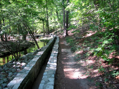
Back on the Trail, the next feature is the Old Grist Mill, which was moved here from the Elijay area back in the 60’s. If you like the sound of moving water, this part of the trail provides it. You follow the granite runway along a pretty creek. You cross street again and head toward the attractions areas. In this part of the woods, there’s some kind of Garden planted out there complete with a dedication marker, but I have never seen anything planted there. You then will come out of the woods at the main field where the grand Confederate Memorial sculpture can be seen in close proximity. You will then continue back into the woods for the final leg, which includes the walk back up the mountain to the point where it intercepts the walk up trail This part is pretty, serene, and difficult; but worth the effort to get your merit badge.
This is my preferred walking route as you get to nice uphill climbs at the beginning and the very end to really get your heart pumping. Some might add hiking to the top, which would add 40 minutes, 2 miles, and significant difficulty to your sojourn. If combine the two trails, you might just have the very best hike in the Greater Atlanta Area. The only drawback is the $10 parking fee. It has all the other key factors I look for: good exercise, pleasant surroundings to view, moments of tranquility, a sense of accomplishment, and only 30 minutes from downtown Atlanta.


Trail Essentials
Approximate Time: 2-2½ hours
Approximate Distance: 5.5 miles
Trail Surface: Stone, Compact Soil
Features: Mountain View, Lakeside Walk, Ruins, Mill, Covered Bridge, Huge Bas Relief

Overall Rating: A

Scenic Quality: A
Athleticism: A
Solitude: A
Value: A
Parking: $10
Hours of Operation: The Trail doesn’t really close
Facilities: At Attractions area, at Walk Up Trail
Maps: Hiking Map on this Page
County: DeKalb


Hurricane Shoals Covered Bridge

New Look at Something Old map
From Hurricane Shoals Park


Now there’s something about a covered bridge that transports some of us to a different time and place. They are highly romanticized. But what is it about them? Is it their age? I ask this because I see a small trend in Modern Covered Bridge Building and wonder if it deserves the same notice as the old ladies that stand guard atop our Georgia Rivers. I tend to lend toward thinking so, and thus the story of the Hurricane Shoals Covered Bridge in Maysville, GA.

To be fair, it wasn’t like the folks of Jackson County just up and decided to build a new modern covered bridge one day. This new bridge is built on the site of the “Old” Hurricane Shoals Covered Bridge (photo here) erected way back in 1882, when the area had need of a bridge for the nearby mills. That 127 foot town lattice style bridge was burned to the ground after 9 decades of service by heartless vandals on Memorial Day of 1972.

After years of effort, funding was made available to rebuild this bridge in 2002. The bridge has the same dimensions and style but is clearly built with modern know-ho. This re-envisioning of the romantic countryside sentry is definitely an interesting object to contemplate for a moment. How many great things of the past can we actually improve on? Or does this modernism diminish its aesthetic purpose? I won’t answer these questions for you, but I do promise to show a few other modern bridges on this site in the future.

This bridge stands as a connector between the two parts of Hurricane Shoals Park in Maysville. On one side you have the tumbling waters of the North Oconee River and the other you have the old building of their pioneer village, which were discussed at length in previous articles.
From Hurricane Shoals Park
What you have in the Hurricane Shoals Covered Bridge is a nice modern interpretation of a classic idea. It sits just a pretty as the others, if not a little cleaner, and maybe a little happier. This bridge is a welcome addition to the Georgia Landscape.


Hurricane Shoals Park

Roaring Waters & Historic Buildings map
From Hurricane Shoals Park
The ideal place for me to visit has a number of different attributes. Two of which are a location within a reasonable distance of my home and something interesting to see. If it is free, then all the better. I was doing a little research on another place when I happened across a location in Jackson County, two counties up from Gwinnett and about an hour and fifteen minutes Northeast of Atlanta, that meets all these criteria. The place is the county’s one and only park, known as Hurricane Shoals Park in Maysville, Georgia.

Now, I work off Hurricane Shoals Road in Lawrenceville and I always wondered how the word Hurricane ever got associated with someplace this far inland in Georgia. And my visit to Hurricane Shoals did answer that. It is a derivation of the Indian Word Yamtrahoochee meaning something like “tumbling or roaring waters.” Over the years, these roaring waters were updated and Anglicized as the more poetic Hurricane Shoals, without any actual Hurricane. Interestingly enough, 90% of the time you would visit you get a peaceful and serene tumbling of water in a most bucolic setting along the North Oconee River. But I tend to chase water after heavy rain, so I got to see first hand what the Indians meant by the name (Video at bottom of post).

The water is the first draw to the park. And there are the ever present picnic spots and playgrounds. They also have one of the nicest Miniature Golf Courses I’ve seen in a public place and a disc golf course also. But the other big attraction is a Pioneer Village, that is one of the nicer collections I have seen in the area. There’s about 15 old buildings, many of which you can walk inside. They include a church, a courthouse, several log cabins, a corn crib, a smokehouse, an outhouse. I would put their collection right up there against most all the villages of this kind I have seen. And the true boon is the general accessibility; we were able to enter at least a half a dozen.

If you want to construct your visit as if it were a hike, it was very reminiscent of New Echota, though the trails are not even laid. If you park by the shoals, you walk up the road, across the covered bridge (did I mention the Covered Bridge? I’ll discuss that at a separate entry), and a short ways up on the left there’s the pioneer village. You make a circle around the buildings then head back to the covered bridge cross and walk across the shoals on a thin bridge. On the other side is the minigolf course and the mill. After heading along the water, where the stone runway is evident, you can recross the bridge and explore the other side of the water’s edge. Walking in this manner will put you above 1 mile but shy of 1.5 miles and you get your exercise. Besides the furious water, there were ducks and other wildlife and plenty of places to sit back and get your fill of nature.

So if you’re a county and you are only going to do one park, my advice is do it big. The folks in Jackson County knew this and built Hurricane Shoals Park for us to enjoy. My understanding is that what I saw was only a small fraction of what was to be seen (I didn’t even make it to the Mill as I had an appointment to make and dawdled a long time marveling at the rushing water). I would like the folks who built this fine park to take this post as my sincere thank you for giving us Georgians something so nice. I promise I will be back.

Trail Essentials
Approximate Time: 1.5 hours
Approximate Distance: 1.5 miles
Features: Ruins, Tumbling Waters, Covered Bridge, Pioneer houses

Overall Rating:

Scenic Quality: A+
Athleticism: C
Solitude: A-
Value: A
Parking: Free
Hours of Operation: April thru October 9am-9pm (March & November 9-6 weekends only
Facilities: throughout the park
Maps: None
County: Jackson

Poole's Mill Covered Bridge

WATER UNDER THE BRIDGE Map
From
It is pretty hot outside as it gets this hot every year. I often get slowed down by the heat. One only has a few choices. Stay Inside. Get out at dawn. Go outside to go inside. Or get wet. The last answer made me think of a place that marries a great swimming hole with one of my other fascinations: covered bridges. The place is Poole’s Mill Covered Bridge just under 1 hour North of Atlanta in Cumming, Georgia (Park website here ).

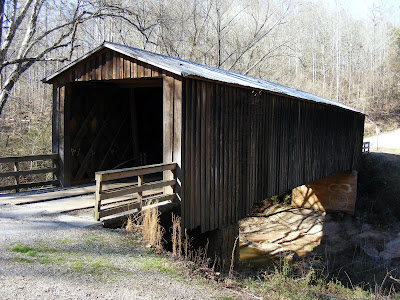
The covered bridge was built in 1901 in the town lattice style while Dr. D. L. Pool owned the land as an addition to a gristmill and sawmill he had on that property (The reason for the extra “e” in the current titling is a mystery). Its 95 feet long, 14.5 feet wide and spans the waters of Settendown Creek. The bridge did collapse in 1980 but it was refurbished and a wonderful park built around it. 
The most noticeable feature in the park is the number of folks playing in the waters of the cascades of Settendown Creek just a few dozen yards downstream. I’ve taken to wearing clothes that allow me to cool off if the opportunity presents itself, but I only went in up to my knees. There’s even an old tree swing allowing kids to dive into the slightly deeper waters nearer the bridge.

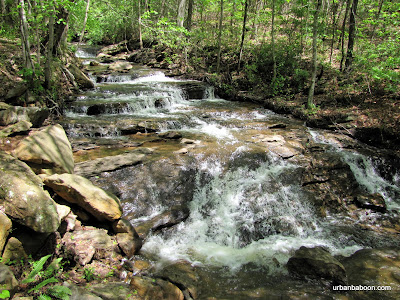
As for the hiking trails of the area, there’s about 1.1 miles of trails, which are pretty easy. There’s a fence downstream that you can get around in order to explore the stream further, if you like. We went this way rather than the main path away from the bridge which leads to Miller’s House (a private residence that was once the supervisor’s home for the mill). Along the way, and aside from the bridge, you get nice views of falling waters, good rock formations, and pastoral quiet river views. We also saw some ducks and the always fun to watch swimming dogs. There were people picnicking and getting some sun. I would categorize this more of a pleasant walk than a meaningful hike, but that doesn’t mean it wasn’t enjoyable. It actually means that it’s more kid and dog friendly.

So in my commitment to eventually see all of Georgia’s Covered Bridges, I give you Poole’s Mill Covered Bridge. A nice walk in the park and a good place to cool off not too far from home.


Trail Essentials
Approximate Time: 1 hour
Approximate Distance: 1.2 mi
Trail Surface: Compact Soil, Rocks
Features: Covered Bridge, Waterfalls, Riverside views

Overall Rating: B

Scenic Quality: A
Athleticism: C
Solitude: C
Value: A
Parking: Free
Hours of Operation: Closes at Dark and November thru Spring
Facilities: Yes
Maps: none, not really necessary
County: Forsythe

PATH: Arabia Mountain Trail (Bicycling)

Mountain to Mountain Biking
Map to Panola Mountain Trailhead
Map to Arabia Mountain Nature Center
From PATH Arabia to Panola
About 18 months ago, I gave away my bicycle to a high school student in need of transportation to and from summer school. I rationalized that I wanted to get a better bike anyway and that I would go do that soon. A scant year and a half later, with some stellar service and guidance from JC at the Dick‘s Sporting Goods near Lenox, I am now back on the road.


For our first venture out of the gate, we chose the Arabia Mountain Trail in DeKalb County. I had hiked Arabia before and I always wanted to make the run on my two-wheeler. The complete path is 22 miles with some nice thigh crunching uphills and exhilarating downhills, but we started at the Arabia Mountain nature center, limiting our sojourn to 16 miles.
south

Two words of caution: First, if you are making the complete trek I would start at the Panola Mountain Trail head near the Dekalb Rockdale Border. By starting where we did, you got some beautiful downhill runs to get the excitement building at the start, but they become two miles of mostly uphills for miles 15 and 16 after you are pretty tired on the way back. Second, when the boardwalk says “Slippery When Wet” and its wet, it is very slippery. We had the enjoyment of participating in a ugly three bike wreck less than a mile into our journey, and of course I was the first to taste the boardwalk wood.
the

The Path Foundation did an extremely admirable job with this trail. You pass the rock outcrops of Arabia with its colorful and exotic blooms. You run alongside a creek for a short portion. There’s a modern take on a covered bridge you zoom across on a long straight downhill. There’s a great bridge and sandy area to take a break at the South River at a point they call South Beach. And the Panola Trailhead is just across Lake Alexander which makes for a terrific mid point or end point depending on your direction. The very North end of the path takes you either to Stonecrest Mall or downtown Lithonia depending on your whim, but as I said we cut this part out of our trip.
creek

I’m not giving up on the hiking. It makes for better clearing of the head and better photos, in my opinion. But if you are looking for a great way to get the blood moving, to enjoy the thrill of zipping down a hill, and want to see some great scenery, I can’t imagine a better place to start for the novice biker than the Arabia to Panola Path Trail. You could walk it if you want but even the 16 mile trip we took would probably require 5 or 6 hours.
lake


Biking Essentials
Approximate Time: allow 4 hours
Approximate Distance: 22 miles
Skill Level: Intermediate, principally due to distance
Trail Surface: Paved
Features: Granite outcrops, modern Covered Bridge, Mountain View, River View, Lake View
Overall Rating:
Scenic Quality: A
Athleticism: A
Solitude: A-
Value: A
Parking: Free at several locations
Hours of Operation: Daylight hours
Facilities: At Panola Trailhead, At Nature Center
Maps: here
County: DeKalb

Watson Mill Covered Bridge State Park

Better Know a Covered Bridge: Watson Mill  Map
Watson Mill Covered Bridge State Park
From WATSON MILL COVERED BRIDGE

Earlier this year, I traveled to see the State’s Longest Covered Bridge, which sits as the centerpiece for a very nice 1000 acre state park situated at about 2 hours West and North of Atlanta (about 45 minutes West of Athens) near Comer, Georgia. The park bears the name of the Bridge and is called Watson Mill Covered Bridge State Park.
Riverview of Watson Mill Covered Bridge

Now we came for the Bridge, a magnificent structure spanning 236 feet across the Broad River. It was built in 1885 by renowned bridge builder W.W. King in the town lattice style (A little History here ). It was built to replace an earlier bridge which washed out during one of the “freshets,” or flash flooding. I have read that the bridge is not in use, but you can drive across it and the road you are on will take you back toward Athens, so I think that information is incorrect.
Powerhouse Ruins

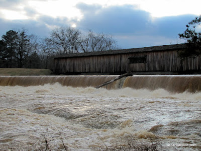
On the day we went, in February of 2010, we experienced one of these freshets. The water was raging under the bridge and over the dam about 15 feet away. The banks of the broad river widened greatly covering the rocks and the land trees were growing from over a much greater span than the long bridge. It’s my understanding that the area is very popular for playing on the rocks and swimming, but there would be none of that this day.
Raging Water under the Bridge

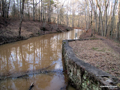
To our surprise, we found two very nice hiking trails on the both sides of the river. Both gave exceptional views of the river and bridge, but the North side was more interesting. Aside from a couple of well placed viewing platforms, they have some nice ruins of the old powerhouse. You get to walk a short two mile loop along the stream and back along the raceway (or vice versa). The South side loop runs about 2.5 miles beginning on the shores of the Broad river but then circling into the woods in what is billed as a nature trail, which could also be a fairly simple bike path.
Broad River's Raging waters

Some of the covered bridges I have visited in the past, were simply little stop bys on the way to or back from another destination. The Watson Mill Bridge and surrounding state park can stand as a destination in itself: A nice 4.5 mile walk; a pretty river and historic bridge, and the possibility of a quick dip in the river along the rocks
Along the raceway

Trail Essentials
Approximate Time: 2-2.5 hours
Approximate Distance: 4.5 miles
Trail Surface: Compact Soil, Rocks, some wooden stairs
Features: Riverside View, historic Bridge, Ruins
Overall Rating:
Scenic Quality: A
Athleticism: B
Solitude: B
Value: A
Parking: $5 (standard state park fees-2010)
Hours of Operation: Daylight hours
Facilities: At the welcome center
Maps: North side (not needed), South Side (Blazed)
County: Madison County

Stovall Mill Covered Bridge

A Very Sad Baboon map
Stovall Mill Covered Bridge
From Stovall Covered Bridge

Well, I am a bit angry and very sad to have to report this to everybody. Most of you know that I am attempting to visit, among other places, every covered bridge in Georgia. And this one particular covered bridge had been getting bumped from my travels due to the onset of night over and over again. It was very close to Helen, Georgia and I always figured I could get it next time. But as luck would have it, I made it to the Stovall Mill Covered Bridge, camera in tow, this past weekend.
Stovall Bridge across the water

Now, I was prepared for a lot of things. I knew that this was the smallest of the covered bridges, being one lane wide and a mere 33 feet in length. So I thought I might be a little underwhelmed by its tiny size. I knew that it wasn’t built by one of the famous bridge builders, but rather by Fred Dover, a local man, who owned the grist mill and some other nearby businesses. But, having also read that it was featured in the 1951 movie, I’d Climb the Highest Mountain, I figured that it would be worth a quick visit.
Stovall Covered Bridge

As I approached the site, just three miles North on 255 off 75 out of Helen, everything looked good: easy access, nice little stream with a old handmade dam next to it, and the beauty of rustic brown Georgia wood. But what I found inside made me a little sick to my stomach, the entirety of the inside was littered with graffiti. It was a desecration. A beautiful piece of our Georgia countryside was destroyed by idiots most of them leaving their names on the wall. Gale, Dennis, Robert, Beverly, & Zach (just to name a few) should be ashamed of yourselves and if you are ever found you should be prosecuted and forced to do restitution. If you know one of these people, punch them hard in the arm for me. If you are one of these people, get a few of your buddies together and head to the White County Historical Society to apologize and offer to help repair what you damaged, hopefully not irrevocably. This whole thing makes this baboon very, very sad.


Now if you can look past the graffiti, what you have is a wonderful piece of Americana. A cute little covered bridge built way back in 1895, easily 80 years before the hoodlum vandals were born. The woodwork on the inside is a maze of beam unlike any other bridge I have seen. It even has its own ghost story , the claim being that if you stand in the middle of the bridge at night you will hear babies crying or the approach of unseen horse drawn carriages, but alas we went in daylight hours, but I’ll check back later.
the handmade dam nearby

And if you are a visitor to our fair state from someplace else, there is a lot to love about this area, and I am one of its chief proponents. So please do not judge us by the handful of morons who do things such as this. Most of us are bright decent people, the vandals, such as those mentioned, are the ones that give credence to the idea that we began as a penal colony

Euharlee Covered Bridge

She Runs and Laughs Map

Euharlee Covered Bridge
From Euharlee Covered Bridge


In part four of my 17 part series., “Better know a Georgia Covered Bridge ,” I traveled a little over an hour Northwest of Atlanta to the town of Euharlee, Georgia , a town so happy its very name means “She laughs as she runs.” Now I’m not all that certain what she’s laughing at or running from, but what I found was a quaint little town near Cartersville, where they are building a park around the Euharlee Creek Covered Bridge .

inside the Bridge

This bridge sit’s a stones throw off Stilesboro Road, on Covered Bridge road, at spans a majestic 137 feet in length and better than 16 feet in width. It is on the National Register of Historic Places and part of the Covered Bridge Trail of Georgia. It is considered historic, probably because it was built by an contractor of African Descent, the son of Horace King , W.W. King (though some sources indicate that another man helped in the design and construction), and its age, being constructed 120 years ago. The bridge is constructed in the town lattice style and has interesting number marks and insignia still visible which gives it a quirky sort of “paint by numbers” feel.

Bridge across Euharlee Creek

This bridge was commissioned to be built in 1886 by Daniel Lowry, owner of Lowry’s Mill and most of the land around the area, after a more poorly constructed bridge collapsed killing one man (a Mr. Nelson), a mule, and a horse. The new bridge has yet to claim a life and serves as the centerpiece of what seems to be a new park endeavor for Euharlee. They even have a big festival celebration each Labor Day Weekend.

the Ruins from the Bridge

Three notes of interest about this site: first, the ruins of Lowry’s Mill remain a short walk away from the bridge and are fully accessible, and yes I do have a thing for ruins. Second, there seems to be a museum operated by the locals put in a nearby shed. There is an interesting story about that place written by a Kennesaw State student here . And finally a couple of blocks up the road is a Black Pioneer Cemetery filled with very “Blair Witch Project” looking unmarked stick cross grave markers. There’s purported to be better than 300 buried there. I mean no offense to anyone by saying that it looked creepy, but we hit this place just as night was falling and it gave me a disconcerting feeling (Should one feel comfortable in a Cemetery?).

Lowry’s Mill Ruins

There is more to see in the Bridge Area as they are restoring some other nearby old buildings. I look forward to one day seeing the completed project. It appears that the city of Euharlee knows how to preserve its culture, so I put this here as a suggestion that you take advantage of it.

Euharlee Creek beneath the Bridge

Elder's Mill Covered Bridge

110 years old and still kicking map
From Elder Mill Covered Bridge


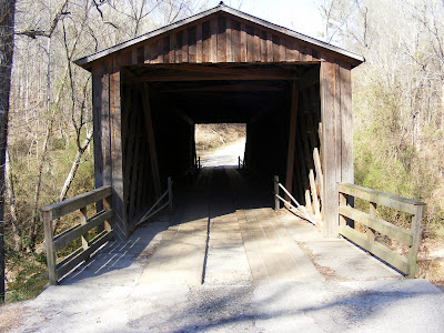
There is an argument as to how many covered bridges exist in Georgia. The Georgia DOT has 16 on their list, the purists argue that the number should be 13 or 14 due to stylistic differences, or more prominently upkeep has changed the very nature of the structure. But anyway you slice it, a covered bridge spanning a piece of water in the Georgia Countryside is a pretty sight. There is one not to far from Athens, in the town of Watkinsville where you get the treat of still being able to drive across in your car. This is the Elder‘s Mill Covered Bridge .


We stopped by there when we were driving South on 15 from Athens to Eatonton. There’s a sign for the turn pointing out the Bridge and its located a scant 8/10ths of a mile down the aptly named Elder’s Mill Bridge Road. A tremendous spot to stop and stretch your legs on a car trip.


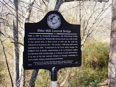
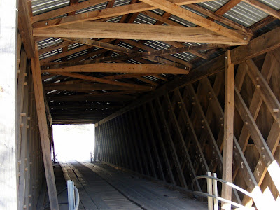
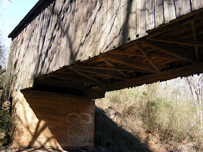
The Bridge was built by Nathaniel Richardson in 1897 and it originally carried folks across Calls Creek on Watkinsville-Athens Road (which I believe may now be 441). After a little over 25 years of use, the bridge was moved to its present location in 1924, carried by wagon by John Chandler. The new creek it spans is Rose Creek, which I have seen referred to as Elder’s Mill Creek, and, alternately the bridge is sometimes called the Rose Creek Bridge. The bridge is 100 feet long and is built in the town lattice style. I couldn’t find out much about the Mill itself except that it closed down in 1941, and was presumably near the original Calls Creek site.


Not exciting enough for you? Danger you are looking for? Looking for more thrills than picturesque scenery? How about going there knowing this: this bridge has the second lowest structural safety score, according to a 2007 Federal Highway Administration scoring a 14.5 (out of 100). But don’t fret, it sits on a sporadically used road and we crossed it twice without a single gasp. And considering its still usable after 110 years without reinforcements, I’d say that’s some fine American workmanship. And remember, its still a beautiful spot. The Watkinsville Garden Club has done some planting on both sides of the bridge, and there is even some grumblings it might become a full fledge park one day.


But remember, as the popularity of covered bridges waned, and time took its toll, we only have 13 (or 14 or 16) of these historical structures to get to know and appreciate. Elder’s Mill Bridge sits waiting for you, if you are ever in Oconee County, as a pleasant reminder of things past.

ShareThis

Related Posts Plugin for WordPress, Blogger...