Showing posts with label Location-Less than 1 hour. Show all posts

Stone Mountain Loop Trail

Best Hike I waited too long to write about.  Map
From Stone Mountain Cherokee Trail


When I go hiking, more often than not, I am very goal orientated. I want to climb this mountain, or see this waterfall, or whatever. I realize that there are some truly great hiking trails that don’t have some sort of ultimate goal. Places where hiking is wonderful on its own terms: you get outside into nature, you stretch your legs, and get your heart pumping. The strange thing about these types of trails is that I don’t rush back and feel compelled to write about them right away. This particular trail I hiked for the first time about 5 years ago, and probably walked along its paths better than two dozen times. And I have written extensively about it surrounding home: Stone Mountain Park, but until today I have never told the story of the fantastic nearby walking trail: Cherokee Trail.

This trail has several names. Officially, it is known as the Cherokee Trail on the maps you get at the gate. But it’s often called the Stone Mountain Loop Trail or the Stone Mountain National Recreation Trail. Any way you slice it, it is one of the finest trails in the Atlanta Area. Boys Scouts can even earn a merit badge for completing it. If you search the internet, you will see it listed sometimes as 5 miles, sometimes as 5.5 miles, and sometimes as 6 miles. To clear this up, my belief is that the true white blazed Cherokee Trail is 5 miles long. However, many folks walk a longer loop, which keeps the trail easy avoiding any part of the mountain, but lengthens the stroll to 6 miles. If you enter via the free parking at the Stone Mountain Visitor Center you can start the trail on the connecting trail in question. However, my personal recommendation on how to do the trail is the 5.5 mile way.

Start at the Stone Mountain Walk up trail and walk up the mountain as if you are heading to the top. After walking about ¼ mile, keep your eyes open for two stone markers noting the Cherokee Trail. You can turn right or left here, I prefer right taking the trail in a counterclockwise direction. First you will get some very different views of the mountain as you descend: Rocky, Desolate, and Beautiful. There’s a sign here saying that this might be dangerous when wet and I assure you this is true. Follow the white blaze into the woods below. The bulk of the trail except for the mountain part gives pretty good tree cover making this walk quite doable even in the hottest months. You will meet up with the connecting trail shortly. Those who do 6 mile version tend to do it for those reasons: keeping the difficulty down and staying out of the sun.

The first marker you encounter is known as the old homestead, which is really simply the remains of an old chimney. You will continue out of the forest, across the road by the playground. At the end of the playground there is a nice little pond to look at. You then continue to the lake. The lakeside walk gives some very nice views of the mountain as well as Lake Venable itself. After crossing a bridge, your time with the lake will be over, and soon you will encounter Stone Mountain Covered Bridge, first at a distance on the water, and then at a place where it can be crossed. I normally cross the bridge knowing full well that it’s off the trail. Being just shy of the halfway point around, it makes a good quick break spot.

Back on the Trail, the next feature is the Old Grist Mill, which was moved here from the Elijay area back in the 60’s. If you like the sound of moving water, this part of the trail provides it. You follow the granite runway along a pretty creek. You cross street again and head toward the attractions areas. In this part of the woods, there’s some kind of Garden planted out there complete with a dedication marker, but I have never seen anything planted there. You then will come out of the woods at the main field where the grand Confederate Memorial sculpture can be seen in close proximity. You will then continue back into the woods for the final leg, which includes the walk back up the mountain to the point where it intercepts the walk up trail This part is pretty, serene, and difficult; but worth the effort to get your merit badge.
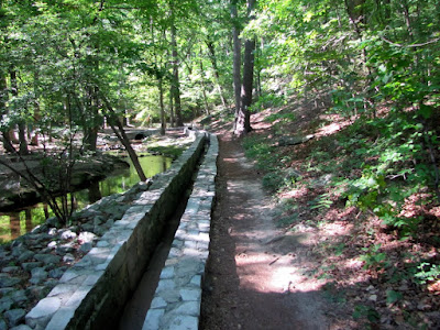
This is my preferred walking route as you get to nice uphill climbs at the beginning and the very end to really get your heart pumping. Some might add hiking to the top, which would add 40 minutes, 2 miles, and significant difficulty to your sojourn. If combine the two trails, you might just have the very best hike in the Greater Atlanta Area. The only drawback is the $10 parking fee. It has all the other key factors I look for: good exercise, pleasant surroundings to view, moments of tranquility, a sense of accomplishment, and only 30 minutes from downtown Atlanta.


Trail Essentials
Approximate Time: 2-2½ hours
Approximate Distance: 5.5 miles
Trail Surface: Stone, Compact Soil
Features: Mountain View, Lakeside Walk, Ruins, Mill, Covered Bridge, Huge Bas Relief

Overall Rating: A

Scenic Quality: A
Athleticism: A
Solitude: A
Value: A
Parking: $10
Hours of Operation: The Trail doesn’t really close
Facilities: At Attractions area, at Walk Up Trail
Maps: Hiking Map on this Page
County: DeKalb


Moore's Ford Lynching (part I)


Part I (Background)
From Moore's Ford Lynching


65 years ago, as of the publishing of this post, a terrible event occurred in the vicinity of the place where we all live. When you hear of tragic events like this, a part of your mind thinks, maybe wishes, that it is only a thing of the past to be forgotten like the Horse & Buggy or the 8-track tape. But there is a danger in forgetting too much history, especially the parts that make us nervous or queasy. My attempt to alleviate the perils of history forgotten will stand with the GABEO, and there presentation of the events surround the last mass lynching in the United States, or what is most commonly referred to as the Moore’s Ford Lynching.

The Dark event occurred on July 26, 1946 (Time Article). Not so long ago that there aren’t people still alive who remember the event. Four black people, George & Mae Murray Dorsey and Roger & Dorothy Malcom, were taken from a car at the bridge across the Appalachee River at the Walton-Oconee County Line, where they were repeatedly shot, some reports say 60+ shots were fired, ending their young lives. There is much more to the story: It came during a period when the idea of lynching a black person was something society knew was a practice, especially in the South. It came at a time prior to the rise of Civil Rights leaders such a Martin Luther King, and any real semblance of equal citizenship for black Americans. This was the way things were done in that period of American History, as ugly as it may be, we do ourselves great harm if we look away.

The Georgia Association of Black Elected Officials (or GABEO) feels the same way. And for the past several years they have held a commemorationof the event of that dark July night. This year is was this past Saturday, July 23rd. The first purpose is to keep this unsolved case from seeping out of our collective memories. The second purpose is that it stands to reason that somebody who lives in the area may have information that could bring the perpetrators of the murder to justice.

The Day began with a rally at the First African Baptist Church of Monroe at Noon. I can attest by my present that all were welcome to attend this event. It gave the organizers about two hours to get everyone together to make the trip around Monroe. During this time, Black elected leaders, community leaders, and religious leaders spoke to edify and amplify the attendees. There was also a fair amount of music and an introduction of the actors.

The first scene was done at the church. The players were Barnette Hester, Roger Malcom and Dorothy Malcom. Apparently, Barnette had made some disparaging comments about the propriety of Dorothy Malcom, and Roger aimed to do something about it. Roger confronted Barnette and a scuffle ensued. In the melee Roger stabbed Barnette and then fled. The historical versions of this event say that Barnette was armed with a pitchfork, and that it may have been sexual advances or even actions toward Dorothy that raised Roger’s ire. Any way you slice it, it was not a good time in history for a black man to stab a white man. Roger ended up caught and imprisoned for 11 days. In the past this part of the reenactment was held in front of Barnette Hester’s house at 2932 Hester Town Road. But due to logistics, and some trepidation, they decided to do this part at the church.

Click here to continue to PART TWO

Moore's Ford Lynching (Part II)

Part II – The Graves and Sites
From Moore's Ford Lynching


There then was a break from the action. They had made a decision to visit the graves of the victims and they were buried in three separate locations. The first stop was the Mount Perry Missionary Baptist Church in Appalachee, Morgan County. Here the bodies of George and Dorothy (Malcom) Dorsey were interred side by side. Most of the graves at the cemetery were simple wooden crosses, and when the Dorseys were buried they had the same. The Moore’s Ford Committee placed granite markers on all the lynching’s victims some years back. In front of George’s grave, there was a plaque recording his military service record, including the three medals he earned in service for our country during WWII. A prayer was said over the grave and we moved on to cemetery #2: Chestnut Grove Baptist Church in Rutlege, Morgan County, where Roger Malcomwas buried. Roger’s grave looked pretty much the same as the other, an elegant granite slab replacing the modest original marker. After the benediction here, we moved to another headstone, that of Lynn McKinley Jackson who died on August 8, 1982. Lynn was found hanging from a tree in Walton County, and even though most might think it suspicious, the local authorities ruled it a suicide. According to the GABEO leaders, they believe he was lynched as a result of his being involved in interracial relationships. After a prayer over Mr. Jackson’s grave, we moved on to the final gravesite.

The entire motorcade journey would wind up taking us better than 60 miles in total. The distances between the gravesites were the most substantial being 15 miles or better. The path to Mae Murray Dorsey final resting place took us through Hestertown. Hestertown, if you recall, was where Barnette Hester’s farm was and where the first scene was supposed to take place. Along the road, there were several old houses and barns, forming what might be almost a stereotypical idea of what rural country life in Georgia is like. The strange thing was the number of folk sitting on their front porches watching us drive slowly down there road. Many of them waved at me. This would normally be an endearing portrait of Southern warmth, if the fact was not known that there was little doubt someone from there either knew something, or knew someone who knew something about the unsolved murders. Were they greeting us or letting us know they had their collective eyes on us. It was an eerie experience.

Mae Murray Dorsey was buried at the now defunct Zion Hill Cemetery at 224 Alcovy Street in Monroe, Georgia. If you go to this site, you will notice a small office park with numerous small businesses. We parked there and in a field adjacent to the parking lot there were a fair number of graves marked with simply wooden crosses. We made our way down to the granite marker commemorating Mrs. Dorsey’s death. The marker has been place in the field apparently next to the grave of a member of Mae’s family because the actually grave is somewhere under the paved parking lot. A sad story true, but no more than the entire situation.

We then made our way to the Monroe Courthouse Annex IV at 203 Milledge Avenue in Downtown Monroe. In 1946, this building served as the jail where Roger Malcom was kept for the stabbing of Barnette Hester. At this site there were two reenactments. The first was of Eugene Talmadge’s stump speech taken from notes and recordings of the day. Mr. Talmadge had arrived in Monroe, two day s after the Hester stabbing. In this speech, he makes several references to purifying the Democratic Primary saying that black can vote in this election, but if elected he’ll make sure blacks won’t be voting in the next. The implication is that a racially inflammatory speech might have riled the mob into action against Roger Malcom. Some sources imply there was a direct deal between Talmadge and the Klan that their version of Justice would be permitted. The second reenactment centers around a man named Loy Harrision. Mr. Harrison had been George and Roger’s employer and apparently Mae and Dorothy were able to convince him to put up the $600 to get Roger out of Jail. Loy, pulled up in his car, along with George and the two women, and bailed Roger out. For the moment, the four were happy and filled with a spirit of reunion. They would work off their debt to Mr. Harrison and life might just return to normal.

But that brings us to the final reenactment, we drove down to Moore’s Ford Bridge. On the way, we saw the historical marker at the corner of Highway 78 & Locklin Road. Continuing down Locklin, 2.4 miles later we were at the bridge. The exact location is Mt Carmel Church Road, where the Appalachee river divides Walton and Oconee Counties. We had to walk about a half mile down to the bridge. It is now a concrete modern bridge, but at the time of the lynching it was a simple wooden structure. There is a signpost for Moore’s Ford Road, but there really is nothing there but a dirt path. At this place, the final confrontation was dramatized. For some unknown reason, Mr. Harrison decided to drive this circuitous route how with his four black travelling companion. We piece together the event of the day based on Loy’s testimony. First, armed Klansmen stop the car at the bridge, they pull the George and Roger out kicking and screaming. Roger’s crime was known to all, but apparently George had become to uppity after the coming back from the war or possible he was too friendly with white women. Mae recognized one on the armed men, and then the women had to be dispatched because they could have no witness. The four were tied together with a rope and shot over sixty times to make sure they were dead. They were then left in the field to rot. Hours later, funeral director Dan Young came to pick up the bodies for final preparation. Prayers were said and songs were sung concluding the reenactment.

Click here to continue to PART THREE

Moore's Ford Lynching (Part III)

Part Three – Conclusion

From Moore's Ford Lynching


In the interest of fairness I want to address a few issues that cause some turmoil around these reenactments.  The first is the strange call for accuracy.  A number of people thing that the reenactment is inaccurate, but the presenters know full well that there is not a valid account of the murders.  If there were then the perpetrators would have at least been tried.  If you rail about inaccuracy then you probably know something and should assist the authorities to finding justice.  Aside from the actual shooting, they point to the story of Dorothy Malcom’s pregnancy  as being apocryphal.  Laura Wexler, who wrote the definitive book on the subject, Fire in a Canebrake, as well as her family members disagree with this stance.  The presenter of the reenactment claims that he was told of the pregnancy by the funeral director Dan Young.  This idea is even recorded, using the word “reportedly” on the historical marker.  Those who believe the story even gave the child a name a few years ago, fittingly, it was “Justice Malcom.”  To those who object to this story, I say who really cares if she was pregnant or not?  Does it make the crime of murdering four people better?  As if somehow, a person might think I can live with you accusing me of murder, but don’t you dare label me an abortionist.  Albeit if it were true, it would add a fifth lost soul to the mix.  If the idea gets you riled, I think that’s the point.  They want you to come forward and set the record straight.  If I were making stuff up, I would do a lot more than just have the one girl pregnant.  I might go with the one report that had the Klansmen having sex with children, animals, and other men in a bloodlust frenzy.   You can’t tell me it didn’t happen, unless you know something and should come forward for the sake of justice.
The second thing to note is that this is not the last lynching in history.  We already talked about Lynn McKinley Jackson’ s story at Roger Malcom’s gravesite.  I was also told the story of Fredrick Jermaine Carter, who appears to have been lynched way back in December of 2010.  Sure, this wasn’t Georgia, but rather Mississippi, and it was ruled a suicide, but it has all the earmarks of good old fashioned mob justice.  These stories make us all understand the importance of remembrance.  We need to be vigilant against the atrocities that mankind is capable of so that we can minimize, stop, or prevent the darkest side on the human soul from gaining control.  I would be nice to think this American problem of lynching has been solved, but you would be kidding yourself. 
The final thing is probably the most scary to me, personally.  I’ll start by addressing the most frequently asked question: “If Dorothy, Mae, Roger and George were shot, why is it called a lynching?”  A lynching can mean the hanging of a human by rope from a tree and that may be the most common form of these murders, but in a more general sense it means putting someone to death without legal means, most often by  a mob.  That was the case in the Moore’s Ford murders.  The thing that scares me is the lynch mob mentality I see around us every day.  And it’s more than a black and white problem.  We sit a mere month out of this big Casey Anthony trial in Florida, and although acquitted, I’ve heard more than one person say she should be killed.  It’s a running meme on the internet to get Dexter and Casey introduced.  The comedians are joking about her guilt without regard to the justice system.  But a day like last Saturday helps me realize that the very same passions and rage which stopped the car at the Moore’s Ford Bridge, which led to the shooting death of four black people, are the same passions we kindle today.  We must learn to not just love justice, but to respect it.  To understand that the trial by jury is the seed from which all democracy and freedoms grew, planted in the Magna Charta centuries past.  If we can’t respect Justice in our community, then we no longer have a community and have digressed to the worst possible outcome of democracy: Mob Rule. 

Serenbe Farms

Up and Went, Palmetto, GA  Map
From Serenbe Farms


When somebody uses the words, “organic farming community,” my first thoughts are of some kind of hippie throwback community with folks who make their own clothes and odors of patchouli drown out odors of, well, other things. Not exactly my primary thought when I’m looking for a getaway with my significant other. But so many Atlantans just love the place. It usually wins the readers polls for best daytrip. So when the right moment came, this monkey made an afternoon trip to Serenbe Farms in Palmetto, Georgia.

Serenbe Farms is exactly as it states a farming community using organic principles to emulate sustainability. Its produce can be sampled at three dining establishments in the area, as well as some Atlanta restaurants like Restaurant Eugene or Holeman & Finch. For the record, I like the principle of sourcing things locally and understand that if there was only organic farming, there would be a lot more starvation in the world. I think the folks at Serenbe get the idea: if you are blessed with the prosperity to allow yourself to make more environmentally friendly decisions, you really ought to, but I digress.

What you get to see at Serenbe is three basic elements. First, there are the Farmlands, which radiate a well maintained and rustic beauty. Farm Tours are available, but take some prior arrangement that we did not make, but one can still walk along the path enjoying its aesthetic beauty without understanding the agricultural science behind it. Second, are the shops and services. The reputation Serenbe has garnered has made it attracted a number of shops for your perusal. They are pricier, high end, sort of things, I would rarely buy from, but often find it fun to stop and look around. I will note that the wine store had a significant number of items under $20, so kudos to them for having something for the everyman.

Finally, and probably, the most notable attraction at Serenbe are the Restaurants themselves. There is a quaint little bakery shop called the Blue Eyed Daisy, which seems to be open most of the day, and doubles as the area’s grocery store. And then there’s the two major restaurants, The Hil, a more upscale eatery in the commercial district, and the Farmhouse, which is part of the original Farmhouse and Inn, where we chose to eat. Both places take and basically need reservations, and as I have said, we just up and went with no planning, but both offered to seat us without reservations, as long as we arrived immediately upon opening at 5pm (the website now says they open at 6p). We considered this generous and gladly accepted.

From 4-5pm outside the dining area at the Farmhouse, they had significant drink specials for happy hour. If my memory serves, mixed drinks were half off, and this wasn’t in the advertising. So we had a drink and waited for the doors to open. Then menu was simple, choice between two starters ($6), two entrees ($18), and two desserts($5). This made the deciding process quicker, but might hamper the more finicky eaters. I had the pork chops over grits, while my companion had the chicken dish. All the food was organic and local and very tasty. The menu does change regularly, but the format remains the same. We had planned to spend the afternoon at nearby Cochran Mill Parkexploring the trails, waterfall, and mill ruins, but the necessity of being at the restaurant at exactly 5pm curtailed that excursion.

So why do I think people love this place? Because it is sort of an oasis from what you normally see on a day to day basis in the Atlanta Area, and the food is authentic, organic, and really good. The Farmland and the area around the Farmhouse was the most beautiful. The commercial district was little weird to me, as I have a guttural disdain for planned playgrounds that only the affluent can enjoy, that comes from so much of my life being lived in the Shadow of Disneyworld. The Farm seems real and true to its purpose, the business district seems to be an overpriced and fairly surreal, a place where people should visit like a museum or a zoo but not live.

Restaurant Fundamentals

The Farmhouse at Serenbe
Address: Hutcheson Ferry Rd, Palmetto, Georgia
Hours: Thu & Fri 6-9pm, Sat 11:30-3pm, 6-9pm, Sun 11:30-3p
Phone: 770.463.2622
Website: Serenbe Farmhouse

Cultural Significance: B
Food Quality: A+
Healthiness: A
Price: B
Value: A

Overall Rating: A

Recommendations: I would suggest you order as much local vegetables and sides as you can. The Fried Green tomato on the salad was probably the best I’ve ever had.
Significance: Sustainable, organic, Farm to table restaurant ahead of its time.


Buford Dam

The Birthplace of Lake Lanier Map
From Buford Dam


Recently, there has been a lot of talk about the dangers of the Chattahoochee River with outdoor enthusiasts being in need of rescue. In more extreme cases, drowning occurs. And it seems that all the blame for this goes to a little marvel of modern technology known as the Buford Dam.

Built in 1956, the Buford Dam does several things for us in Metro Atlanta besides try to kill us. It does a nice job of Flood Control with only two significant floods South of Dam since its inception. It provides power; it aids in wildlife management; and it helps with our water supply. In order to do these things, it has a continuous release Schedule that is irregular. Water is released from Lanier daily, but some days it’s a little and some days it’s a lot. The more water that is released the more dangerous the river becomes, so check at the phone number (770) 945-1466, so you will be adequately prepared.

Visiting the Dam is an interesting excursion in its own right. Some write this up as a trail, and so I will do the same, but I warn it is very short at only about a mile, if you park at the Lower Overlook Park to save on parking fees at the Dam itself. On the bright side, it is a very easy excursion for those who can do limited physical activity, the physically-challenged, or even small children.

In the one mile space, 3 things jump out at me of interest. The most obvious of which is the rocks and formations of the dam itself. There is a nice little steel frame bridge with great views of the dam or down the Chattahoochee. The second is the sheer clarity of the water. As the water released from Lanier comes from the bottom of the lake, it is crystal clear in spite of the heavy boat usage there. Finally, and probably the most odd, is the wildlife in the area. Of course there’s ducks and fish, and that’s to be expected. But there are also a fair number of goats living just inside the fences at the dam.
You can also watch the fisherman at work (or do they call it play) as it is popular for this activity.

So if you looking for an interesting side excursion on your trip to Lanier or a short jaunt off the LLaurel Ridge Trail Laurel Ridge Trail on your more extensive hike, the Buford Dam is a shouldn’t miss place just at the Forsyth-Gwinnett County Border. On a beautiful day, it is another option to get you outside. And the sirens you hear are announcing the release of water.

Trail Essentials
Approximate Time: ½ - 1 hr
Approximate Distance: 1 mi.
Features: Dam, River View, Wildlife

Overall Rating: C+

Scenic Quality: A-
Athleticism: C-
Solitude: C-
Value: B
Parking: Free (lower overlook park) Charge at Dam Parking
Hours of Operation: Daylight Hours
Facilities: At Lower Overlook Park
Maps: None, Follow Laurel Ridge Trail to Dam (marked trail), and return same way
County: Forsyth

Harbins Park

Gwinnett’s Bike Park Map
From Harbins Park


Really nice places to Bicycle are hard to find. They can be too short or too easy or too long or too difficult. Especially, when you are talking offroad biking. I’ve seen fellow rider who barely bat an eye at 30 miles on paved surface quit after a couple of miles of singletrack dirt. And this is because Mountain Biking is pretty hard work. One of the better places I have found for the novice to intermediate mountain bicyclist is Harbins Park
near Dacula, GA.

The Park is relatively new being built late in 2009. And it appears to be constructed with the bicyclist as the primary focus, which makes it the first of its kind in Gwinnett County. There are trails marked for Equestrian and Hiking use, but only the 4.5 miles of paved trail are the usages combined, giving the Bicyclist the right of way on his path (Maps downloadable here).

The Bike Paths are a series of loops that are rated intermediate. Because Mountain Biking is difficult, I’m not always looking for the hardest thing I can find. I’m looking for a place I can have a bit of fun and work up a bit of sweat over an hour, or maybe two hour period. Harbins is probably the best I’ve seen fulfilling these requirements.

There’s also a pretty little stream, some form of runoff of the Alcovy River, which makes for a pleasant picture and calming sound of rushing water. It also makes a good place for a break in a pastoral setting. There is also a big hill near the telephone lines, which I’m simply not crazy enough to tackle, but had some fun watching others risk they’re necks. Another nice thing is that the longer paved trail intersects the bike trail in several spots which allows for an easier break of flatter Earth or to back out and quit if the feeling should present itself.

If want a really hard dirt trail, skip this one and go to the nearby Fort Yargo. If want pretty easy, skip this one, and head to the nearby trail at Tribble Mill Park. But, if you are like me, and looking for a medium challenge like me, somewhere in between, Harbins Park in Gwinnett is just right. There’s a nice video by Singletracks on YouTube here.


Mason Mill Park (Decatur Waterworks)

The Old Decatur Water Works and more to come Map

From Mason Mill Park

I read every email I get and respond to all of them—eventually. The subject of this post was first suggested to be by Chris F via email in 2007. It was also listed as a regret in an email to me by Dave K. of urban outdoors back in 2009. So in characteristic Baboon fashion, I made my jaunt to this location in the Spring of 2011. Better late than never someone once said. The best reason I can give for the delay is that it is really a small park, better suited I had thought for a stop by than an excursion on its own. Mason Mill Park in Decatur, Georgia packs a lot of interesting stuff in a small package, just 20 minutes outside of Atlanta.

Probably, the most famous thing about this park is that it houses the old Decatur Waterworks ruins. Built in 1906, this site provided water to Decatur utilizing South and Burnt Fork Creeks until the 1940’s. Since then the structure has fallen into decay and ruin, but I say that in a good way. They are known by locals simply as “The Ruins,” and like many structures off the beaten path they have also fallen prey to vandalism or graffiti, depending on your perspective. I found the graffiti fascinating, something about the entirety of the work or the irony of a man made structure placed in nature, getting overrun by nature’s entropy, being covered with man-made attempts at communication. I digress, let’s leave it as it is a good place for photos.

The second thing is the Park itself, or rather the Park inside the Park. Apparently, when the waterworks were an operating facility, the company had built a little park out of the greenspaces nearby. As the Mason Mill Park expands it is encompassing parts of the old park. The finest feature of this old Mason Mill Park is the stone bridge that crosses Burnt Fork Creek. The creek is quiet, babbles in places, and has some ruins of a dam structure just a little way North of the Bridge.

The final thing is the Hiking and Biking. I’m not going to write this up as a hiking blog, because the trail is strange, short, and undefined. This is more of the type of place you simply explore around for a while, rather than try to accomplish any one thing. I spent about 2 hours there, and may have spent more, if I didn’t have to meet someone for dinner. On the Bicycling side, this area is nearby and easily explored on Mountain Bike. Also, it appears the PATH Foundation is building a paved connector that will eventually link North Druid Hills to Emory University. There are some that oppose this, and I admit that I like a dirt path more than paved personally, but I understand the average bicyclist wants easy paved roads. And the added interest in the area brings preservation.

Well, there you have it. Mason Mill Park contains the remnants of the Decatur Waterworks, a pretty little creek, and a future bicycle path. That’s packing a lot into a small space. To get to these places within the park, you have to travel to a dirt road at the far end of McConnell Drive past the Tennis Courts, just so you know.


Morgan Falls Overlook Park

Sitting on the Dock of the Sluice Map
From Morgan Falls Overlook Park

New Parks get me excited. Especially, when they are done well, have something significant to offer, and are located terrifically close to me. Now, this doesn’t mean I get around to seeing them right away, but it does make my list of things to do. The freshly minted city of Sandy Springs (2005) unveiled a newly minted park in late Summer of 2010. So when I had a little time to on my hands, I made my way over to the Morgan Falls Overlook Park.


Now, the park is rather small at 35 acres, but the planners did a lot with a little bit of space. There’s a rather impressive playground and picnic pavilion, but that wouldn’t be the chief reason for the park. The place’s centerpiece is the splendid view of Bull Sluice Lake on the Chattahoochee. In order to enjoy the view, Sandy Springs has erected about a dozen or so bench swings, that make for a great spot to sit and watch the water or the sunset above the Trees.


But there’s more. In building the park, they uncovered the remains of an old homestead, once belonging to the Powers Family. The home had a massive chimney that was kept intact and perches regally near the edge of the small peninsula. So you get some ruins on a picturesque backdrop. Additionally, there is a small floating dock, which gives a good place to fish or to launch your canoe to explore Bull Sluice. The Georgia Tech Kayak Club calls this place home now.


And there’s a little hiking opportunity. There is a paved trail that runs along the lake. It can’t be more than ¼ mile, and runs from swings to chimney, down some stairs, along the pier, and then along the water back to the parking lot. There is also a short compact dirt hiking trail that may be a little difficult to find. It runs up and down the bluff and the entrances are at the street side of the parking lot as you enter or at the backside of the pavilion by the horseshoe rink. For such a short walk, it is decent exercise because of the incline. There are three places marked as overlooks on the trail, but the best view is either of the parking lot at one end, or just above the pavilion on the other. The overlooks may improve in parts of the year with less leaves on the trees. You could very easily combine these two trails to get a very competent 1 mile trail, very near home.


So if you are looking for pretty place for a nice walk without the expenditure of too much time, Sandy Springs overlook park serves up a welcome quick retreat. A few quick notes: First, to reach the park you drive down Morgan Falls road which is unpaved, in poor condition, and may actually make you think you missed your turn. Second, the Morgan Falls Dam is around the bend to the South and the falling water is not visible from this location. And, finally, because of its proximity to the people of the city, there may be few opportunities to be alone with your thoughts.


Trail Essentials
Approximate Time: 15-30 minutes
Approximate Distance: 1 mile
Features: Lake and River Views, Ruins

Overall Rating: B-

Scenic Quality: B+
Athleticism: C+
Solitude: C
Value: A
Parking: Free
Hours of Operation: Daylight, not exactly sure
Facilities: At Park
Maps: not needed, at entrance to park
County: Fulton


The Silver Comet Trail

THE LONGEST PAVED BIKE PATH IN GEORGIA Map
From Silver Comet Trail

The Granddaddy of all bicycle trails in Georgia is the Silver Comet Trail. Heck, it might be the Granddaddy of all bike trails in the US. It runs almost 64 miles from Smyrna to the Alabama State line, mostly on what was once the railroad track used by Seaboard Railroad’s Atlanta to Birmingham line. If you continue through Alabama on the Chief Ladiga Trail it will take you 96 miles, all the way to Anniston, Alabama. The road is paved, relatively flat (3% overall grade), and is completely off roads used by cars, except for a few crossings, and a very short patch in Western Polk County. So how does one write a good article about this unique attraction just 13 miles outside of Atlanta. Well, you probably have to ride the whole darned thing.

On Oct 2, 2010, The Urban Baboon and three close friends set out to do just that. The longest I had ever biked in one day up to that point was 32 miles. Our plan was to drive two vehicles out to the Highland Station parking lot in Smyrna, drop the smaller car there, cram the five of us (we needed a driver) and four bikes into the minivan and be dropped at Esom Hill, near the State line, and then have the driver go back to Highland Station and leave the van there for us when we finished. The beauty of this plan was its simplicity. The downside was there was no turning back.

At Esom Hill, there is a small parking lot close to the Alabama border. It is quiet and serene and there are no facilities there. The nearest place for any supplies or amenities is in Cedartown, about 7 miles away. In order to say that you rode the entire trail, you need to head west first about .3 miles to get to the archway that makes up what they call Stateline Gateway Park, not much of a park, but a fitting starting point for a day on two wheels.

The Polk County portion is the least travelled part of the trail. The 7 miles to Cedartown run by farms and fields. It is also the most hilly portion of the trail with a few noticeable inclines and descents. At Cedartown, there is a depot where supplies are available, though you are required to walk you bike in front of the store. The next stretch to is a bit more of the same, about 14 miles to downtown Rockmart. We used this as our first breakpoint. Rockmart has a nice little park and a fair number of businesses very near the trail that could be of use to the Trail Rider. We had originally planned to lunch here, but it was only about 10:30 am, so we took a short break and rescheduled lunch for Dallas. Rockmart is the lowest point on the trail, so the rest of the route is uphill, but fairly gentle, almost unnoticeable.

The next section contains the longest isolated stretch of the whole journey. After the last Polk County Trailhead at Coot’s Lake, you travel 11.5 between trailheads. The tradeoff for the isolation is you get the most scenic stretch of the entire trail. Coot’s lake is a pretty piece of water. About 2.6 miles East you cross through the 800 foot long Brushy Mountain Tunnel. Exiting the tunnel you pass through the Paulding Wildlife Management Area. We actually saw wild turkeys on the path, but other wildlife might be possible. You then cross the Pumpkinvine Creek Trestle , a 750 foot long railroad bridge, just west of the Rambo Trailhead. Both the Tunnel and the Trestle are worth the stop to look around, but we didn’t as we had miles to go, and had been there before. Rambo is a fairly amenity free parking location, but if you continue another two miles to Tara Drummond, there’s accessible restrooms and water.

By the time we reached Dallas, our group of four had significantly separated into two groups of two, so we skipped lunch because we were to far behind. From here to Smyrna the path gets progressively more crowded as you get closer and closer to the city. And this is the area where you see the most road crossings. The trade off for lack of serenity is the comfortable feeling that you are not too far from help, should it be necessary, and after 40 miles under your belt, this is good to know. You cross through Hiram, leave Polk County, and go through Powder Springs and Mableton. Once in Cobb County, there are some nice walking trails off the Comet, near Center Road (Wildhorse Creek) and Concord Road (Heritage Park). The road gets pretty straight and pretty crowded the rest of the way. At the Floyd Road trailhead, there’s a bike shop. When you get to mile marker Zero at Mavell Road you are not actually done, there is still a mile to go principally uphill to reach the Highland Station Parking lot.

For a trip of this magnitude, preparation is far more important than usual. The three chief concerns are water, food, and bike maintenance. Water is crucial. I read a post somewhere where they said that you should also bring a camera, so that when you run out of water you can sell it to get more water. I travelled with a 72 oz. camelback which I filled and drank three times, with only one bathroom break. Food is another important consideration, I calculated on a website that six hours of moderate riding for someone of my size would burn about two days worth of normal meals. I packed a case of Power Bars and ate all but two. Bike maintenance is a lesser worry, because the trail is clean and paved, but you should travel with essential repair tools including a flat tire repair kit, air pump, and bike wrenches, just in case, it would be awful to be stranded a long time in certain areas.

The 64 mile trek is not normally for the casual rider, like myself. It took me a little over 7 hours to complete with significant and well needed breaks. The faster two riders finished about an hour ahead of us. The beauty of the Silver Comet Trail is that you can bite off as much or as little as you want. Most people use the Cobb portion of the trail, probably due to its proximity. But the best portion is in Polk County. My recommendation for the more casual rider is that you put in at either Hiram, Polk Chamber of Commerce, or Rambo and head West to Rockmart. There you can eat lunch or whatever and then return back to your original spot. This way you get at 32-38 round mile trip hitting most of the highlights of the road, with a nice place to stop to break the work in two.

Bike Trail Essentials
Approximate Time: 6-8 hours (allowing breaks)
Approximate Distance: 64 miles
Trail Surface: Paved
Features: Small Georgia Towns, Rolling Countryside, Bridges, Trestles, Tunnels, Lakes, Rivers, Wildlife

Overall Rating: A

Scenic Quality: A
Athleticism: A+
Solitude: B
Value: A
Parking: Free (Various Locations)
Hours of Operation: Daylight Hours
Facilities: At many trailheads
Maps: Silver Comet Website, Trail Express, Google, and
Path Foundation
County: Polk, Paulding, & Cobb


ShareThis

Related Posts Plugin for WordPress, Blogger...