Showing posts with label Location- A Bit Farther Away. Show all posts

Gorges State Park NC
(Horsepasture River)

One, two, three, four…4 beautiful waterfalls bah ah ah Map
From HorsePasture River Falls


I always feel a little guilty when I talk about something not in Georgia, like I’m abandoning my adoptive home state for something I think is better in a new state. It’s not like I’m cheating on my wife or anything. The point of this website is to show really cool places to hike or visit within a reasonable drive of Atlanta, normally 3 hours. This place Google maps puts at 3 hours and 16 minutes from downtown Atlanta, but you know the way we drive, if you can’t make up the 16 minutes on the road, then you’re probably not from Atlanta. And this place is really cool, I am talking about the Waterfall Hike on the Horse Pasture River very near Gorges State Park in Sapphire, NC, North Carolina.

I read about this hike in the Back of the Dillard House Cookbook. It seemed almost too good to be true with 4 waterfalls in such a short distance. But If you are going to spend three hours in the car, you want something kind of special. When we got there, it was just a pleasing as advertised. I must note that you should beware of other information on getting to these falls. North Carolina State Parks closed one path in May of 2009 and set up the new path out of Gorges State Park (the Cookbook’s directions were to the old spot). You drive into the park about two miles, and the parking is clearly marked and as of Oct 2010 free. There are two paths leading out of the parking area, and the way to Horse Pasture River is the one on the right. The path actually takes you out of Gorges State Park and into Pisgah National Forest, so when you see the signs saying you are leaving the State Park, you are going the right way.

The first 1.5 miles of the trail is rather uneventful. At about 1 mile you start seeing the river downstream of the falls. In this area, there is a small falls (about 5 feet) called Hidden Falls. At 1.5 you see the granddaddy waterfall of the trip Rainbow falls, dropping a majestic 150 feet. You can view this fall from just about any angle you want but be careful, as this point is the only point that has any kind of precautionary railings.

About .25 mile up from Rainbow Falls, you come upon Turtleback falls, this is one of those falls just perfect to play in. I’ve seen kids slide down the 20 foot falls and cool off in the waters below. There isn’t the kind of danger here that the 150 foot falls presents. If you continue about .25 miles up from here you will get to the edge of the public land and can view Drift Falls. Remember, Drift Falls in on private property and if you get caught in it, you will be fined. Somewhere downstream from Rainbow Falls is Stairstep Falls, to which I didn’t travel. It is supposed to be about a mile downstream from Rainbow Falls.

So if you, like me, like waterfalls and a good hike and don’t really mind a three hour car ride, Gorges State Park offers tremendous bang for your buck by these criteria. I know a lot of folks have recommended several places for me to visit in NC. If they are half as good as this one, then you know I will be back.

(in the video I mistakenly refer to Hidden Falls as Stairstep Falls)

Trail Essentials
Approximate Time: 2-3 hours
Approximate Distance: 4.5 mi round trip
Features: Waterfalls, Riverside Walk

Overall Rating: A

Scenic Quality: A+
Athleticism: B+
Solitude: B
Value: A
Parking: Free
Hours of Operation: Daylight hours for Parking
Facilities: None (Oct 2010, but there are plans)
Maps: Downloadable on this page
County: Jackson County, NC

Cumberland Island

FERAL HORSES, PRISTINE BEACHES, & THE RUINS OF A CASTLE Map
“The
From Cumberland Island


Well, in my travels and talks with folk in Georgia, people often say, “you gotta go see…” I appreciate the suggestions and I take them all seriously. There seems to be one place that seems to get mentioned a lot and it has until 2010 stayed off my travels because it is beyond my self imposed limitations on this website, sitting beyond a 3 hour drive, being 5 hours away, tucked into the very Southeasternmost point of Georgia. So with this post I am creating a new category for the website entitled “A bit farther away” and starting it with a little information about Cumberland Island .
Deformed Trees

Cumberland Island is probably the most well known, the largest, and certainly the most pristine of all of Georgia’s Sea Islands. It is 17.5 miles length and its greatest width is no more than six miles, though in most places its much thinner, often less than a mile. There is no bridge to the Island and you must take Ferry over from St. Marys, Georgia or arrange for private charter. It has beautiful relatively untouched beaches, saltwater marshland, and a maritime forest with gnarled oak trees. Because the earliest Ferry leaves St Mary’s at 9 am and the latest departs the Island at 4:45 pm (Schedule and Reservations) there is really no way you could hike the 50 miles of trails in a day trip, so unless you are camping, you will probably limit yourself to walking the Southern loop, leaving out all of the North Island sights, like Plum Orchard or the First African Baptist Church . This is what we did, but don’t worry there’s still plenty to enjoy.


The Island has stayed pristine due to the lack of settlement. There have been times when there were larger groups of people on the Island. The original settlers were Timucuan Indians , then a Spanish Catholic Settlement, and later a period of plantations and slaves. But, fortunately for us, during historical periods of rapid construction, the Island was in the hands of a single family or at best a small cabal of families. The first was Nathanael Greene’s descendents just after the turn of 19th Century. The latter being the Carnegies, who amassed owner ship of about 90% of the island, starting around 1880. The high point for population came just before the Civil War, with 500 Gullah slaves working the plantations with less than 75 white settlers and overseers. Today, there are still families living there complete with homes and cars, mostly descendants from the Carnegies or those in their employ. But by agreement, upon passing of the families the land will revert to the government, creating a complete National Seashore Conservation site.
Dungeness from the front

The South end loop still has plenty to offer. There are three majors things of interest there. First, as was previously mentioned is about two miles of perfectly deserted beach. The only people you will see are the handful of campers and those that came over on the boat with you, as access is restricted to 300 people daily. The quantity of seashells, if your into that sort of thing, are unparalleled (and it’s the only thing allowed to be taken from the island). The second items of note are the wildlife and the ecology. You walk between fantastic oak, Spanish moss, and palm trees. There feral horses are the most famous animal occupants, but unfortunately we missed them (although there was ample evidence they were there). But we saw armadillos, wild turkeys, and several species of flying birds. The hiking details are listed at the end of the post.
Dungeness Castle

The final thing is the ruins of Dungeness Castle . Built by Thomas Carnegie and finished in 1886 after his death, and destroyed by fire in 1959, it is the most magnificent piece of Georgia Ruins I have seen. One can only imagine (or look at old photos) the opulence of the site in its heyday. A much smaller version of Dungeness was built by the Greene family in 1802 and the restored tabby house next door serves as a reminder of that previous era. Nearby there are ruins and some restorations of companion buildings including servants quarters, storage houses, and their activities building. There are also some very interesting rusted out automobiles and the original resting place of General Lighthorse Harry Lee (the man who proposed American Independence) though he’s been moved and we were unable to find the marker.
Rusted Cars

So I’ve been raving about this place for a few minutes now, but I would be remiss if I didn’t mention the things of which to be wary. First, you must pack a lunch and water and all necessaries as there is no way to purchase anything, save water at the ranger station. There are places in St. Marys to buy pack lunches, if you are unable to make them yourself (We got ours at the Riverfront Inn for $7 a person). Second is the cost, the ferry ride is $17, with an additional admission of $4 to the park ($2 extra bucks a night for campers - 2010 prices). If you throw in the hotel/motel stay, it is certainly not a cheap excursion. You can easily discount the cost of the boat ride as a neat event in itself. And as I have said, I was very pleased with what I spent my money on. Finally, there’s the time limitation. You can walk the 2.5 mile Southern loop in an hour, give yourself an additional hour to both play around on the beach and to frolic in the Dungeness area and you are still left with an hour till the return ferry arrives (if you take that later morning voyage). You can easily double back on some of the internal trails in search of more wildlife, as we did. But you know you can’t make it to the northern sites and back, so the trip leaves you somehow wanting less and more simultaneously.
Spanish Moss

We stayed in St. Marys, a historic event it is own right. Our hotel was the the Riverview Hotel (a bargain for a bed and breakfast type atmosphere at just North of $100 bucks a night for a room with a view). There is less expensive lodging at the Cumberland Inn and even cheaper accomodations 8 miles away in Kingsland. We ate at Captain Seagle‘s Restaurant and Saloon one evening and the Borrell Creek Landing another, but there are less expensive options up the road 5 or 6 miles. The Saloon at the Inn is great hangout for locals and visitors and I consider myself fortunate to get cussed out by the infamous Cindy Deen the Porno Queen who runs the joint.
Ferry back to St Marys

Trail Essentials
Approximate Time: 2 hours (with sightseeing)
Approximate Distance: 2.5 miles
Trail Surface: Compact Soil, Sandy Beaches
Features: Ruins, Wildlife, Ocean Views, Marshland

Overall Rating: A-

Scenic Quality: A+
Athleticism: C
Solitude: A
Value: B+
Parking: ample at the Seashore Ferry Landing and free
Hours of Operation: Closed Christmas, No Tues or Wed during the winter, Visitor Center 8:00 am to 4:30 pm
Facilities: yes, thankfully
Maps: Available at the Visitors center
County: Camden County

Westville, an 1850's town

STEP BACK INTO GEORGIA IN THE 1850’s MAP

From Westville


When I tried to explain to my friends my desire to go to Westville, in Lumpkin, Georgia [Stewart County], I told them it seems like it is a place that, much like Helen, Georgia is to Germany, it is to our state 150 years ago. That description is only mostly accurate, Helen is much more touristy with restaurants, shopping centers, and its ilk. Westville is simply what it claims to be a working pre-civil war Georgia town, you be hard pressed to find a fine dining experience in the vicinity, but there’s some nearby good BBQ.

“typical

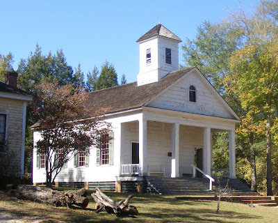
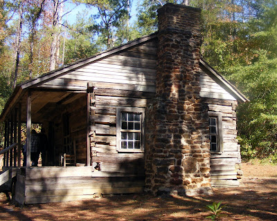
I hesitate to call it a hike, but you should wear comfortable shoes because you’ll walk along dirt roads for about two miles during your visit. What you see is quite interesting, you walk along and see over thirty pioneer Georgia buildings. From Churches to a General Store to a Doctor’s office; from the rich Singer’s home to poor farmers Cabins; from blacksmiths to potters to bootmakers shops; its all there in this well thought out open Air Museum.

“Working

When you arrive you have to pay admission at the gift shop, which is $10 for adults, $8 for college students, and $4 dollars for K-12 ($1 off coupon here), and exchange your money for scrip which is used throughout the venue. In case you want some lemonade or some cornbread (50 Cents each), or take a tour of the land in a mule drawn wagon ($1 a person), you need a little scrip (2 bucks each should suffice). There is a restaurant serving simple food in one of the houses and I believe that group takes cash.

“Mules

Inside you see a town at work. Workers in period gear ply their trades and educate you about what Georgia once was like. Unlike other reproductions I’ve seen, they let the characters be themselves, there's no pre planned script. We met a blacksmith who was complaining about the youths they hired not paying attention as he was trying to teach one how to make a nail. We met a very authentic heavy set black man making “sweetnin” and telling us it was good (making good a two syllable word). This sugar cane syrup was pretty disgusting to my palate, but as he explained it was all they had in the day. There was also a nice older lady who showed us how the loom worked, and as she pointed out all the drapes and linens on the site were made by that loom.


The highlight of the trip was watching a cotton gin actually at work. They had two field hands working the gin. One would run the gin and speak to the visitors, the other tended to the mules which served as its engine. I’ve seen cotton before, and I’ve seen gins before, but I never saw one at work. It was truly fascinating, Most gins of the time used bulls, and they explained that the last bull died some twenty years before, and they switched to mules. There was a giant bailing machine next to the gin, but unfortunately (for me not them) they weren’t bailing that day.

“Down

We went during the harvest festival, and they have several festivals and events throughout the year. On that day, there were singers and musicians in the courthouse, and you could sit a spell and enjoy some tunes. The Courthouse was from Cherokee County and I believe it is the oldest courthouse still standing in this state.


The whole concept is a monument to Colonel John West, a former professor from North Georgia College in Dahlonega. The idea was to save old historic buildings and put them all in one place for future generations to see. All the buildings are real and have come from all corners of the state. I’m glad some folks have the foresight to preserve that which would otherwise fall by the wayside.


If you have kids, I’d say its worth a special trip, seeing it’s a clear two and a half hours outside of Atlanta. For adults, I would say you would be remiss if you were in the area and didn’t stop by. Or could be easily combined with a gorgeous nature walk at Providence Canyon State Park 5 miles away. If you like photography, they actually encourage you to take pictures, unlike most other museums. This is a gem of a place in Southwest Georgia and a pleasant gateway to a world that has passed us by.

Providence Canyon

GEORGIA’S GRAND CANYON map

“providence
From Providence Canyon


Ok, this one’s a little further away, nestled about 150 miles Southwest of Atlanta, and 40 miles South of Columbus, near Lumpkin, Georgia. This puts it at about two and a half hours away, so I apologize. But, and there’s always a but, its well worth the trip. It’s one of the most outstandingly beautiful places in all of Georgia, so beautiful in fact I have a photo listed on the homepage. I am talking about Providence Canyon, known as “Georgia’s Little Grand Canyon”

“providence

This Canyon, another of Georgia‘s Seven Natural Wonders is different in its beauty than other parts of Georgia I have seen. Stepping inside the canyon transports one’s mind to someplace further West. The Canyon is really a series of Gorges, some 16 in all, and some of them as deep as 150 feet. And this erosion tell a story in its splendor. The story is Several Million years of Georgia’s geologic history. Admittedly, the erosion is, in part, man made, due primarily to poor farming techniques, lack of knowledge, and lack of future vision by farmers in the area in the 1800s. I don’t blame them, we learn much from our mistakes. But the byproduct result is a lovely panoramic view of whites, purples, pinks, reds, blacks and browns.

“Providence

Providence Canyon sits within Providence Canyon State Park, and is a dayhikers dream. There is an easy 3 mile trail that takes you down into the Canyon to see, feel, and experience the walls of nine of the gorges first hand. It then leads up and along the rim to view the colors of the walls in its totality. If you want a little more challenge, there is a 7 mile Back Country Trail, but I was warned not to go because the back areas are popular with hunters (if you go check hunting schedules and/or wear bright orange), I personally don’t take chances when guns are involved.

“Junk

As you climb out of the ravine, there are a couple of other interesting things to see. First there’s a strange dead car graveyard that must be at least thirty years old. The signs explain that they have become a habitat to many of the local animals and important in a way that requires them not to be moved, so they will no doubt be there when you make your sojourn.

“Providence

The second is Providence Methodist Church, a church built in the early 1830’s and closed quite a while ago due the danger the expanding canyon presents. The old church is still there and you can explore the old cemetery with graves that date back to the early 1800’s.

“view

Like I said, despite its distance, it is breathtakingly worth the trip, Its also better to get there late in the day to see the setting sun work its magic on the Canyon Walls. If you see it more of an overnighter there is camping, and plentiful reasonable hotel rooms in nearby Eufaula, Alabama. Its also within 5 miles of the equally intriguing town of Historic Westville.


Trail Essentials
Approximate Time: 2.5 hours
Approximate Distance: 3 miles (maybe more if you really explore each gorge)
Trail Surface: Compact Soil, Clay, some wet foot crossings
Features: Majestic Vistas, Colorful Canyon Walls

Overall Rating: A
Scenic Quality: A+
Athleticism: B-
Solitude: B
Value: A (only not an A+ because of distance from Atlanta)

Parking: $3 (standard State Park Rates) [Nov 2007]
Hours of Operation: Closed Nights, Major Holidays
Facilities: At the Visitor Center, other locations along the rim, none in canyon
Maps: At Visitor Center, Online here
County: Stewart County

ShareThis

Related Posts Plugin for WordPress, Blogger...