Showing posts with label Direction-N. Show all posts

Buford Dam

The Birthplace of Lake Lanier Map
From Buford Dam


Recently, there has been a lot of talk about the dangers of the Chattahoochee River with outdoor enthusiasts being in need of rescue. In more extreme cases, drowning occurs. And it seems that all the blame for this goes to a little marvel of modern technology known as the Buford Dam.

Built in 1956, the Buford Dam does several things for us in Metro Atlanta besides try to kill us. It does a nice job of Flood Control with only two significant floods South of Dam since its inception. It provides power; it aids in wildlife management; and it helps with our water supply. In order to do these things, it has a continuous release Schedule that is irregular. Water is released from Lanier daily, but some days it’s a little and some days it’s a lot. The more water that is released the more dangerous the river becomes, so check at the phone number (770) 945-1466, so you will be adequately prepared.

Visiting the Dam is an interesting excursion in its own right. Some write this up as a trail, and so I will do the same, but I warn it is very short at only about a mile, if you park at the Lower Overlook Park to save on parking fees at the Dam itself. On the bright side, it is a very easy excursion for those who can do limited physical activity, the physically-challenged, or even small children.

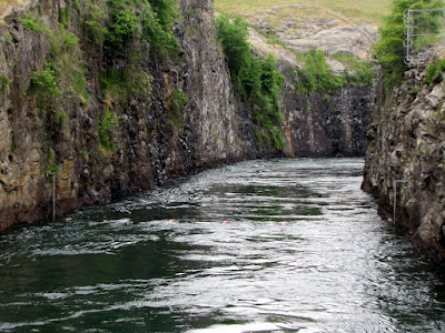
In the one mile space, 3 things jump out at me of interest. The most obvious of which is the rocks and formations of the dam itself. There is a nice little steel frame bridge with great views of the dam or down the Chattahoochee. The second is the sheer clarity of the water. As the water released from Lanier comes from the bottom of the lake, it is crystal clear in spite of the heavy boat usage there. Finally, and probably the most odd, is the wildlife in the area. Of course there’s ducks and fish, and that’s to be expected. But there are also a fair number of goats living just inside the fences at the dam.
You can also watch the fisherman at work (or do they call it play) as it is popular for this activity.

So if you looking for an interesting side excursion on your trip to Lanier or a short jaunt off the LLaurel Ridge Trail Laurel Ridge Trail on your more extensive hike, the Buford Dam is a shouldn’t miss place just at the Forsyth-Gwinnett County Border. On a beautiful day, it is another option to get you outside. And the sirens you hear are announcing the release of water.

Trail Essentials
Approximate Time: ½ - 1 hr
Approximate Distance: 1 mi.
Features: Dam, River View, Wildlife

Overall Rating: C+

Scenic Quality: A-
Athleticism: C-
Solitude: C-
Value: B
Parking: Free (lower overlook park) Charge at Dam Parking
Hours of Operation: Daylight Hours
Facilities: At Lower Overlook Park
Maps: None, Follow Laurel Ridge Trail to Dam (marked trail), and return same way
County: Forsyth
Morgan Falls Overlook Park

Sitting on the Dock of the Sluice Map
From Morgan Falls Overlook Park

New Parks get me excited. Especially, when they are done well, have something significant to offer, and are located terrifically close to me. Now, this doesn’t mean I get around to seeing them right away, but it does make my list of things to do. The freshly minted city of Sandy Springs (2005) unveiled a newly minted park in late Summer of 2010. So when I had a little time to on my hands, I made my way over to the Morgan Falls Overlook Park.


Now, the park is rather small at 35 acres, but the planners did a lot with a little bit of space. There’s a rather impressive playground and picnic pavilion, but that wouldn’t be the chief reason for the park. The place’s centerpiece is the splendid view of Bull Sluice Lake on the Chattahoochee. In order to enjoy the view, Sandy Springs has erected about a dozen or so bench swings, that make for a great spot to sit and watch the water or the sunset above the Trees.


But there’s more. In building the park, they uncovered the remains of an old homestead, once belonging to the Powers Family. The home had a massive chimney that was kept intact and perches regally near the edge of the small peninsula. So you get some ruins on a picturesque backdrop. Additionally, there is a small floating dock, which gives a good place to fish or to launch your canoe to explore Bull Sluice. The Georgia Tech Kayak Club calls this place home now.


And there’s a little hiking opportunity. There is a paved trail that runs along the lake. It can’t be more than ¼ mile, and runs from swings to chimney, down some stairs, along the pier, and then along the water back to the parking lot. There is also a short compact dirt hiking trail that may be a little difficult to find. It runs up and down the bluff and the entrances are at the street side of the parking lot as you enter or at the backside of the pavilion by the horseshoe rink. For such a short walk, it is decent exercise because of the incline. There are three places marked as overlooks on the trail, but the best view is either of the parking lot at one end, or just above the pavilion on the other. The overlooks may improve in parts of the year with less leaves on the trees. You could very easily combine these two trails to get a very competent 1 mile trail, very near home.


So if you are looking for pretty place for a nice walk without the expenditure of too much time, Sandy Springs overlook park serves up a welcome quick retreat. A few quick notes: First, to reach the park you drive down Morgan Falls road which is unpaved, in poor condition, and may actually make you think you missed your turn. Second, the Morgan Falls Dam is around the bend to the South and the falling water is not visible from this location. And, finally, because of its proximity to the people of the city, there may be few opportunities to be alone with your thoughts.


Trail Essentials
Approximate Time: 15-30 minutes
Approximate Distance: 1 mile
Features: Lake and River Views, Ruins

Overall Rating: B-

Scenic Quality: B+
Athleticism: C+
Solitude: C
Value: A
Parking: Free
Hours of Operation: Daylight, not exactly sure
Facilities: At Park
Maps: not needed, at entrance to park
County: Fulton


Lake Lanier - Laurel Ridge Trail

“The Laving Laurel Turned my Tide” Map
From Laurel Ridge Trail Lake Lanier
Though I don’t have any precise metrics, I believe from personal anecdotal evidence, that Lake Lanier is the most talked about and visited outdoor recreation spot by most Atlantans. And for that reason, I have personally shied away from our man made wonder just an hour North of us. I look for peace and quiet, and massive throngs of people are not conducive to this goal. But I have been told that one of the better hikes near to our area runs along Lake Lanier. It’s called the Laurel Ridge Trail, slightly under an hour away up GA 400 or I-85.


The trail runs, by most accounts 3.8 miles, although the trail markers clock it in at a flat 4.0. It runs a nice continuous loop, and we began at the Lower Overlook Park, where the parking is free. From this point, the trailhead lies just behind the restrooms and takes you immediately across Buford Dam Road.
The trail is well marked and takes you through a series of overlook where you get nice views of Lake Lanier or the Chattahoochee River. It would be best explored in the early spring months or winter as the views are often blocked or diminished by trees full of leaves. The overlooks, except for the first one, are still enjoyable to the naked eye, but the obstacles hinder photography. The path is mostly compact soil, with some boardwalk through the “wetland” portions, and some pavement near the more traditional recreation sites. Although there is no monumental physical challenge, the path does rise and fall enough from ridge to shore and back to make it an adequate workout. I would still rate it as easy, however, I would not say it was simple.


At about the ½ mile mark, the Buford Dam is both visible and accessible on your right. Though this would not be technically on the trail, it would be foolish not to add this short jaunt down to the dam. I will talk more about Buford Dam in a later post because most other sites treat it as a separate trek, as short as it may be. If you cross the wooden bridge and follow that trail it will meet up with the Laurel Trail maybe two-tenths of a mile up from where you departed, adding, maybe, another ½ mile to your journey.


The trail is good for wildlife watching and people watching. Along the way, we saw several smaller birds, Ducks, Goats, and a Deer. On the Lanier side, there are benches and swings where you can view boats and water skiers pass by. The day we went was a little on the cold side and overcast, so we were met with a little more peace and quiet that you may encounter. However, there are stretches of the trail that take you away from the congregation of people that I’m sure there will be some serenity when you go. Additionally, there are wetland areas, a nice little pond, and a beaver dam. A good portion of the trail runs along a petite stream known as Rocky Creek. I will caution you that the trail crosses roads in three locations, two of them being the busy Buford Dam road, so cross with caution. Other than this, it would be an excellent spot for children. When you come out of the long quiet part of the trip, the trail empties out at a playground (at around 2mi). I should also note that under current rules, Dogs are not allowed on this trail.

Most of the hiking I do seems to be goal oriented. Let’s go see this waterfall or climb this mountain or whatever. There is another type of hiking that encompasses the process more than the accomplishment and I appreciate these as well, but they don’t make the most intriguing articles. At the end of the trail, I told my most frequent travelling companion, that within this category, I would rate the Laurel Ridge Trail as the second best trail of the sort behind the underappreciated Stone Mountain Loop Trail. My fellow Traveller thought this one was even better than that.


So if you are looking for nice little day in the great outdoors, and want to get your legs and heart moving a little, the Laurel Ridge Trail deftly suits the bill. And considering its close proximity to most of us, it is definitely worth the trip.


Trail Essentials
Approximate Time: 1-2 hours
Approximate Distance: 3.8 (4.6 with Buford Dam Area)
Surface: Compact Soil, Boardwalk, Wooden Bridges, Some Pavement
Features: Riverside, Creekside, & Lake Side Walk, Lake Vista Views, Buford Dam, Wildlife

Overall Rating: B

Scenic Quality: B
Athleticism: B
Solitude: C+
Value: A
Parking: Free at Lower Overlook Park (paid parking at some Lanier locations)
Hours of Operation: Daylight Hours
Facilities: Throughout the trail
Maps: here
County: Gwinnett County


Snowy Amicalola

Obligatory Snow Post by Atlanta Area Resident Map
From January 2011 Snow at Amicalola Falls

Ok, everybody heard that it snowed pretty significantly this January. And every blogger, twitterer, and facebooker put up their photos of the Atlanta Blizzard. And those who know me and who I am said to me over and over again, why don’t you do something. Well, as the good weather is right around the corner, and my website is technically not open for the 2011 season just yet. I thought I might show you my snow pictures, specifically a revisit to Amicalola Falls the week following the major snowstorm.


Now I thought, with the snow melting that the falls might be raging. And the winter time is best for Amicalola because you can get the full view of the falls through the naked trees. However, the snow had no quite melted enough just yet and the falls, though flowing were not tremendously powerful. I placed a short video at the bottom of this post, so you can see for yourself.


Hiking up to the top of the falls was my first outdoor excursion this year. I was a bit out of practice with two months of relative inactivity literally under my belt. And the climb up to the top of Amicalola is no walk in the park, but we survived a little better than I expected. Never really having clomped up a mountainside over a snow covered patch, I felt good that no one fell and we made it up in one piece. The discovery that frosted trails are pretty slippery wasn’t really a shock, but it did slow the pace a bit as paying careful attention to footwork became a much higher priority.


The bright blue January sky made for beautiful vista views and the waters of Amicalola, though subdued, still came through with enough show to make the day in the Snowy Metro Atlanta Countryside well worth the effort. Amicalola is truly one of the can’t miss sites in North Georgia and well worth returning trips snow or no snow.


Rabun Bald

We’re #2 but we try harder Map
From RABUN BALD


I haven’t climbed up a mountain in a while: partly because it’s hard work, but partly because my circle of friends has focused on other interests like biking and waterfalls. But when the year began, I put two mountain peaks on my list of things to do. We visited Currahee
in the spring, but I forced myself to wait for Autumn for my trek to the other place. Well, the wait is over, October is upon us, and last weekend I made my trek up to the summit of Rabun Bald.


Rabun Bald is Georgia’s Second Highest Mountain and its located way up in the Northeasternmost cranny of our state. The peak measures in at 4,696 feet. The best way to get there actually takes you on a quick trip through North Carolina, a few miles North of Dillard, Georgia. While being just about as far away to the Northeast as you can be, Rabun Bald is only just slightly over two hours away from downtown Atlanta, up I985 and US 23. The Hike begins at the end of an unnamed road past a few houses of Hale Ridge Road. The Parking on the Road is free, but be careful you don’t block any driveways or dirt roads. You’ll know the road by the steep incline after your right turn off Hale Ridge Road. My Sherpa Guide says that the road is gravel, but it has clearly been paved since the books printing.


Most documentation on the trail lists it as 4 miles round trip, and it certainly feels about that distance. However, the sign at the beginning of the trailhead reads 1.6 miles up, which cuts the overall distance by 8/10ths of a mile. Either way, it’s a pretty difficult climb with an ascent of 2350 feet over the 1.6-2.0 miles. There is nary a piece of flat stretch along the way. Even what passes for switchbacks have a good incline. That being said, it’s not the hardest I’ve seen and it’s only a 2 miles, don’t let this discourage you. There is a small flat space about .9 miles up for resting. There’s an old logging road just to the side, which I saw on 4WD Pickup truck drive up. We walked down this way for a change of scenery, and it’s a bit longer of a trek, which may make the whole trip add up to 4 miles.


The payoff at the top is without peer. At the top, there is the first fire tower built in the Geogia, way back in 1912. The fire tower was phased out of use in the 70’s and some industrious youth built a viewing platform there. On the top of this platform, it is said that you can see for 100 miles on a clear day in any directions. There is no clearer, unobstructed view within the state. The video at the bottom tries to capture this effect by standing in the middle of the platform and spinning slowly in a circle. I fear the pictures do not do proper justice to this incredible natural vista. And the October setting allows the first hints of turning Fall leaves. There’s an Indian Legend that says that the mountain is inhabited by fire breathing demon people, but they must have moved away some years ago.


So if you are looking for a challenging hike, or a tremendous mountaintop view, or a chance to see the Fall colors, this is just the ticket. I’ve seen a bevy of beautiful places on my journeys, but this might very well be the prettiest. I would love to the see the Sunset from this vantage point, but that would mean climbing down a steep trail in the dark. Rabun Bald, I thank you for an enjoyable Sunday Afternoon.


Trail Essentials
Approximate Time: 2-2.5 hours
Approximate Distance: 4 miles
Features: Wilderness, Tremendous Mountain View

Overall Rating: A

Scenic Quality: A+
Athleticism: A+
Solitude: A
Value: A
Parking: Free
Hours of Operation: No Formal listing
Facilities: None
Maps: here
County: Rabun


Smithgall Woods

Helen’s Nature Retreat Map
From Smithgall Woods
The third most travelled to destination in Georgia is Alpine Helen. And it might be my most travelled to area because of its receptiveness to the outdoor adventurer. There are several interesting places to hike in the general vicinity. One place eluded me until this year. You see every other time I went hunting was in full force and I simply don’t chance that stuff and find other places to go. But in March of 2010, I was able to make my way into Smithgall Woods Conservation Center and enjoy some of the 23 miles of hiking and biking available to folks such as us.


Unlike most of the area’s outdoor excursions, this one is set up more like a retreat center than a wilderness area. When you enter the wooden fence, you get that feel immediately. I have already mentioned the hunting done on premises, but it is also one of the premier trout fishing destinations of North Georgia. Dukes Creek runs right through the middle of it and its pristine waters make for good fishing as well as a serene backdrop for your day in the woods. The main road, called Tsalaki Trail is paved and takes you to the 5 separate trails designed for the hiker. The trails are mostly short, ranging from .3 to 1.6 miles. We walked four of the five that day, and with the walk up and down Tsalaki, we covered just about 6 miles.


The two most interesting trails are the Ash Creek Trail and Martin’s Mine Trail. Ash Creek explores Dukes Creek and includes two wet foot crossings of the stream, so be prepared. The highlight of this trail is the water itself. Martin’s mine trail was our predetermined destination because we thought it would be neat to see gold mine shafts. There were three different shafts, one of which was filled in, that you could look down. In pictures, they look more like holes in the ground than anything fantastic, but I assure you it was a nice treat on our path. On this trail there was also a minor but quite pretty waterfall, and waterfalls always seem to deliver. The short wetlands path had a nice boardwalk and almost seemed like you weren’t in the North Georgia Mountains. The nearest trail was a simple nature trail, which was ok, and the furthest trail is the Cathy Ellis trail, which we didn’t traverse. There is no dominating mountain climb or deep valley to enter, so I would rate all these trails as very easy, with the possible exceptions of crossing the water on the Ash Creek Trail or the actual climb up to the waterfall, which aren’t difficult, but certainly aren’t simple.


Along the way there are a few other interesting sites. At the Nature Center, there’s a small museum inside and a couple of captive birds or prey outside. Along the Paved Road, you encounter a small covered bridge, called Bay’s Bridge, which was placed there as gift from husband to wife by the Smithgalls, the sites original benefactors. There was also a bee farm, so I encountered my first warning sign that read “Caution Bees.” These added nice extra diversions to our day at Smithgall.


So if you are looking for a getaway from your getaway in Helen, and want a simple but serene day in nature, Smithgall Woods fills this role admirably. Because of the relatively easy trails, I would rate this as a top family destination, and if you include the hawks, bees, and museum, kids are sure to enjoy it. If you fish, you probably already know about this place. I’d advise you call ahead about the possibility of hunting (706.878.3087), it seems the hunting dates are grouped around Helen’s busy Oktoberfest season. Because of the paved middle road, you could bring your bicycles to get from trail to trail. If you go, you ought to take the 2 mile car trip afterward to visit Dukes Creek Falls.


Trail Essentials

Approximate Time: 4 hours (all trails)
Approximate Distance: 6 miles
Features: Waterfall, Riverside views, Marshland, Old Goldmines, Covered Bridge, Wildlife, Bees.

Overall Rating: B

Scenic Quality: B+
Athleticism: B- (mostly because of distances)
Solitude: B
Value: B
Parking: Standard State Park Fee ($5, March 2010)
Hours of Operation: 8a-6p Mo Tu Th Fr 7a-6p We Sa Su
Facilities: At the visitor center
Maps: At visitor center, here
County: White


Blue Ridge Scenic Railway

He’s goin’ back to a simpler place and time…Map
From Blue Ridge Scenic Railway


There’s something in our collective unconscious that thinks trains are romantic. As a person who has actually travelled by train, I understand this in part, but I know it’s mostly being stuck in a cramped box for hours. But still even I tend to romanticize the railroads. Now there are some great things about it, the slow passage of time, views of the American countryside, and the lullaby of rail on steel. A great way to get the best of the rail without the worst of the rail resides about an hour and 45 minutes north of us in Blue Ridge, Georgia at the appropriately named Blue Ridge Scenic Railway.


Leaving the city of Blue Ridge every day except most Tuesdays and Wednesdays (Schedule) is a seven or eight car train that traverses the Murphy Connector between Blue Ridge and McCaysville, Tennessee. The trip is 13 miles one way with an hour break in McCaysville. There are normally two or three open air cars and two or three closed cars so you can escape or enjoy the weather. The cars themselves are restored historic railcars from times past and places as far away as New York City. The trip takes about four hours in total. There are restrooms and a snack car on the train if either should become necessary.


The Summer cost is a little on the high side at $32 (fares) with discounted pricing for Seniors and children 12 and under. But compared to buses, trains, and planes, it’s not that out of line. And what you’re paying for is the experience. You get to rush behind peoples homes and along the serene Toccoa River. Along the way, people run out to wave at the passing trains, you get to see an ancient Indian fish trap, and the occasional encounter with wildlife. This must be a fascinating way to see the fall colors turn, if that’s your sort of thing.


The only negative about the trip is the stop in McCaysville. Sure it’s a cute little country town, and it has this charming blue stripe running through it separating Georgia from Tennessee and the town of McCaysville from Copperhill. But If you’re thinking of dinner, the food is a bit regrettable. We ate at the Nifty Fifties Diner, which had a beautiful view of the river and some nice bluegrass music, but the food was reminiscent of the kind of stuff you’d get at your average bowling alley, but kids may enjoy it. Based on my discussions with fellow travellers, I think your best bets would be the BBQ joint across from the train station (not next to it) or the Mexican eatery.


I write this because I recently received an email about discounts to the rail road for weekday excursions and for reserving the Christmas ride with Santa Claus, if you book before August 31st. The code for the Santa excursion is SUMSANTA10 and the weekday trips is SUM10WEEKDAY, both being good for 10% off (2010 codes). Even at full price, the Blue Ridge Scenic Railway is an enjoyable was to relive the glory days of American Trains without the commitment or hassle of spending too much time stuck in a metal box.

Poole's Mill Covered Bridge

WATER UNDER THE BRIDGE Map
From
It is pretty hot outside as it gets this hot every year. I often get slowed down by the heat. One only has a few choices. Stay Inside. Get out at dawn. Go outside to go inside. Or get wet. The last answer made me think of a place that marries a great swimming hole with one of my other fascinations: covered bridges. The place is Poole’s Mill Covered Bridge just under 1 hour North of Atlanta in Cumming, Georgia (Park website here ).

The covered bridge was built in 1901 in the town lattice style while Dr. D. L. Pool owned the land as an addition to a gristmill and sawmill he had on that property (The reason for the extra “e” in the current titling is a mystery). Its 95 feet long, 14.5 feet wide and spans the waters of Settendown Creek. The bridge did collapse in 1980 but it was refurbished and a wonderful park built around it. 
The most noticeable feature in the park is the number of folks playing in the waters of the cascades of Settendown Creek just a few dozen yards downstream. I’ve taken to wearing clothes that allow me to cool off if the opportunity presents itself, but I only went in up to my knees. There’s even an old tree swing allowing kids to dive into the slightly deeper waters nearer the bridge.

As for the hiking trails of the area, there’s about 1.1 miles of trails, which are pretty easy. There’s a fence downstream that you can get around in order to explore the stream further, if you like. We went this way rather than the main path away from the bridge which leads to Miller’s House (a private residence that was once the supervisor’s home for the mill). Along the way, and aside from the bridge, you get nice views of falling waters, good rock formations, and pastoral quiet river views. We also saw some ducks and the always fun to watch swimming dogs. There were people picnicking and getting some sun. I would categorize this more of a pleasant walk than a meaningful hike, but that doesn’t mean it wasn’t enjoyable. It actually means that it’s more kid and dog friendly.

So in my commitment to eventually see all of Georgia’s Covered Bridges, I give you Poole’s Mill Covered Bridge. A nice walk in the park and a good place to cool off not too far from home.


Trail Essentials
Approximate Time: 1 hour
Approximate Distance: 1.2 mi
Trail Surface: Compact Soil, Rocks
Features: Covered Bridge, Waterfalls, Riverside views

Overall Rating: B

Scenic Quality: A
Athleticism: C
Solitude: C
Value: A
Parking: Free
Hours of Operation: Closes at Dark and November thru Spring
Facilities: Yes
Maps: none, not really necessary
County: Forsythe

Dukes Creek Falls

Chasing Waterfalls 2010 –Episode II Map
From DUKES CREEK FALLS

I like the Alpine City of Helen, Georgia for all the wrong reasons. I’m not a huge fan of their take on food or German Culture. It is nice, I guess, but feels a bit contrived, but I might be oversensitive to this stuff as I went to college in the most contrived city on Earth. What I like is that it remains the most open and inviting of all North Georgia cities and that it is a great base point for many exhilarating treks the mountains. It is the third most travelled to destination of all Georgia cities. So what do you do when you get there: Go see something beautiful in the nature that surrounds it. A short distance away is a fantastic waterfall, one in which these photos actually cannot do justice, known as Dukes Creek Falls.


Dukes Creek Falls drops from Dukes Creek, not from it. The 150 foot drop into the gorge comes from Davis Creek. It is so large and cascading it is nearly impossible to take in as a whole. But can be taken in quite nicely in smaller sections. It is the most majestic of the four Helen Area waterfalls and makes for a simple quick excursion to add to your Alpine itinerary.

The trail itself is marvelously maintained and easy to navigate. It does descend about 400 feet through a serious of three switchbacks. But over the 1.1 miles down the path almost feels flats. At the parking area, you get one of the better views of Yonah Mountain. About .1 mile down, there is a viewing platform that allows a distance view of the upper portion of the falls. Along the second switchback near the midpoint of the trail, you begin to hear the sounds of strong falling water. Shortly after this point, you will get your best view of the whole of the falls, albeit not a good view as it is obscured by trees and may be invisible when the trees are full with leaves.


At the very bottom, there are some nice observation decks, where the bottom of the falls literally envelopes you. And the deck continues a bit further where there is an additional smaller fall along Dukes Creek. Of course, after getting your fill of the falls you have to climb out, which will be tougher. But it really isn’t all that bad, I would place it at about half the difficulty of Stone Mountain.


I would rate this as one of the better short hikes in Georgia. At 2.2 miles with the climb out it would constitute some exercise. The beauty of the falls offers a tremendous payout for your effort. Dukes Creek also flows into Smithgall Woods a few miles South if you wish to do some additional walking.


Trail Essentials
Approximate Time: 1 hour
Approximate Distance: 2.2 miles
Trail Surface: Compact Soil, Boardwalk, Stairs
Features: Waterfall, Vista views

Overall Rating: A

Scenic Quality: A+
Athleticism: B
Solitude: B-
Value: A+
Parking: $3 (Mar 2010)
Hours of Operation: Daylight Hours
Facilities: None
Maps: Not needed
County: White

ShareThis

Related Posts Plugin for WordPress, Blogger...