Showing posts with label Hiking. Show all posts

Stone Mountain Loop Trail

Best Hike I waited too long to write about.  Map
From Stone Mountain Cherokee Trail


When I go hiking, more often than not, I am very goal orientated. I want to climb this mountain, or see this waterfall, or whatever. I realize that there are some truly great hiking trails that don’t have some sort of ultimate goal. Places where hiking is wonderful on its own terms: you get outside into nature, you stretch your legs, and get your heart pumping. The strange thing about these types of trails is that I don’t rush back and feel compelled to write about them right away. This particular trail I hiked for the first time about 5 years ago, and probably walked along its paths better than two dozen times. And I have written extensively about it surrounding home: Stone Mountain Park, but until today I have never told the story of the fantastic nearby walking trail: Cherokee Trail.

This trail has several names. Officially, it is known as the Cherokee Trail on the maps you get at the gate. But it’s often called the Stone Mountain Loop Trail or the Stone Mountain National Recreation Trail. Any way you slice it, it is one of the finest trails in the Atlanta Area. Boys Scouts can even earn a merit badge for completing it. If you search the internet, you will see it listed sometimes as 5 miles, sometimes as 5.5 miles, and sometimes as 6 miles. To clear this up, my belief is that the true white blazed Cherokee Trail is 5 miles long. However, many folks walk a longer loop, which keeps the trail easy avoiding any part of the mountain, but lengthens the stroll to 6 miles. If you enter via the free parking at the Stone Mountain Visitor Center you can start the trail on the connecting trail in question. However, my personal recommendation on how to do the trail is the 5.5 mile way.

Start at the Stone Mountain Walk up trail and walk up the mountain as if you are heading to the top. After walking about ¼ mile, keep your eyes open for two stone markers noting the Cherokee Trail. You can turn right or left here, I prefer right taking the trail in a counterclockwise direction. First you will get some very different views of the mountain as you descend: Rocky, Desolate, and Beautiful. There’s a sign here saying that this might be dangerous when wet and I assure you this is true. Follow the white blaze into the woods below. The bulk of the trail except for the mountain part gives pretty good tree cover making this walk quite doable even in the hottest months. You will meet up with the connecting trail shortly. Those who do 6 mile version tend to do it for those reasons: keeping the difficulty down and staying out of the sun.

The first marker you encounter is known as the old homestead, which is really simply the remains of an old chimney. You will continue out of the forest, across the road by the playground. At the end of the playground there is a nice little pond to look at. You then continue to the lake. The lakeside walk gives some very nice views of the mountain as well as Lake Venable itself. After crossing a bridge, your time with the lake will be over, and soon you will encounter Stone Mountain Covered Bridge, first at a distance on the water, and then at a place where it can be crossed. I normally cross the bridge knowing full well that it’s off the trail. Being just shy of the halfway point around, it makes a good quick break spot.

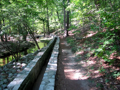
Back on the Trail, the next feature is the Old Grist Mill, which was moved here from the Elijay area back in the 60’s. If you like the sound of moving water, this part of the trail provides it. You follow the granite runway along a pretty creek. You cross street again and head toward the attractions areas. In this part of the woods, there’s some kind of Garden planted out there complete with a dedication marker, but I have never seen anything planted there. You then will come out of the woods at the main field where the grand Confederate Memorial sculpture can be seen in close proximity. You will then continue back into the woods for the final leg, which includes the walk back up the mountain to the point where it intercepts the walk up trail This part is pretty, serene, and difficult; but worth the effort to get your merit badge.
This is my preferred walking route as you get to nice uphill climbs at the beginning and the very end to really get your heart pumping. Some might add hiking to the top, which would add 40 minutes, 2 miles, and significant difficulty to your sojourn. If combine the two trails, you might just have the very best hike in the Greater Atlanta Area. The only drawback is the $10 parking fee. It has all the other key factors I look for: good exercise, pleasant surroundings to view, moments of tranquility, a sense of accomplishment, and only 30 minutes from downtown Atlanta.


Trail Essentials
Approximate Time: 2-2½ hours
Approximate Distance: 5.5 miles
Trail Surface: Stone, Compact Soil
Features: Mountain View, Lakeside Walk, Ruins, Mill, Covered Bridge, Huge Bas Relief

Overall Rating: A

Scenic Quality: A
Athleticism: A
Solitude: A
Value: A
Parking: $10
Hours of Operation: The Trail doesn’t really close
Facilities: At Attractions area, at Walk Up Trail
Maps: Hiking Map on this Page
County: DeKalb


Chattahoochee Bend State Park

Still Got that New Park Smell Map
From Chattahoochee Bend


It’s been 20 years since the State of Georgia has opened a new state park. Not that I’m complaining, they do an excellent job with the parks they run, but when a new park opens after that many years it’s kind of a big thing. The Georgia State Parks department is planning two new parks in the near future, and the good news is that they are both relatively close to Atlanta. The first to open just this month is called Chattahoochee Bend State Park, located about an hour and twenty minutes outside of Atlanta on the Western edge of Newnan in Coweta County.

Now, I live in Gwinnett County, so it’s a little further for me, but I bet that most of you have friends or reasons to be out that way. I have a good friend who lives in Peachtree City and I used the opening of the new state park as good excuse to spend the day with him and his 12 year old son.

Everything there is brand new. The visitor center is pristine, with a half dozen rocking chairs on the porch. The bathrooms are new. The Gift Shop is new. I’m sure the campsites are new too. But what is most interesting to me is that the trails are new. According to the map you can get at the visitor center, there are two hiking trails: One from the visitor center to the campground and the other, which seemed more interesting to us, the one along the Chattahoochee River itself.

To reach that trailhead, continue driving on the park road till it pretty much dead ends. There is a good size parking lot near the boat launch area. The trailhead is to the right of the launch about 150 feet. There were a good number of people using the area not just to get their boats into the water, but to cool off from the hot Georgia Summer. By the looks of things, the water is pretty shallow and calm there.

The trail is a pretty flat walk that goes all the way to the bend that gives the park its name. To be honest, I have to sort of trust them as we didn’t have the time to get there. According to the Friend of the Bend site there’s five miles of trail (and then you’d have to trek back, I don’t know if you can subtract the campground trail). We went up no more than three miles before turning around, but I believe you get the flavor of the trail in that time. The one thing that is notable about this trail is that the river is a little further away from the shore than I might like. And because it’s so new, the small side paths down to the water don’t exist as of yet. But we had fun fighting our way down to the shore in a couple of places. Who knows, somewhere down the line, our trails might become the trails. Along the path, there’s a nice, newly built lookout platform (that probably works better in the winter months), and a part where there’s an internal clearing on the non-river side where we saw a few deer run through.

So if you’re in the Newnan area, or are looking for an easy boat launch, or just want to see the new place, head on down to Chattahoochee Bend State Park. For me, it was a very nice day in nature with a good friend. His son really liked the place (lots of bugs and branches to play on), so I’d give it a better rating for kids. The only drawback was the July Heat, which I can’t fault the park for (The trail is mostly covered and there was a noticeable decrease in temperature on the trail itself).


Trail Essentials
Approximate Time: 3-3.5 hours
Approximate Distance: 10 miles round trip
Trail Surface: Compact Soil, Sand
Features: Riverside Walk

Overall Rating: B

Scenic Quality: C+
Athleticism: C+
Solitude: B+
Value: B+
Parking: State Park Fees ($5)
Hours of Operation: 7am-10pm
Facilities: at Visitor Center
Maps: At Vistor Center, white blazed
General Maps: here or here
County: Coweta


Mason Mill Park (Decatur Waterworks)

The Old Decatur Water Works and more to come Map

From Mason Mill Park

I read every email I get and respond to all of them—eventually. The subject of this post was first suggested to be by Chris F via email in 2007. It was also listed as a regret in an email to me by Dave K. of urban outdoors back in 2009. So in characteristic Baboon fashion, I made my jaunt to this location in the Spring of 2011. Better late than never someone once said. The best reason I can give for the delay is that it is really a small park, better suited I had thought for a stop by than an excursion on its own. Mason Mill Park in Decatur, Georgia packs a lot of interesting stuff in a small package, just 20 minutes outside of Atlanta.

Probably, the most famous thing about this park is that it houses the old Decatur Waterworks ruins. Built in 1906, this site provided water to Decatur utilizing South and Burnt Fork Creeks until the 1940’s. Since then the structure has fallen into decay and ruin, but I say that in a good way. They are known by locals simply as “The Ruins,” and like many structures off the beaten path they have also fallen prey to vandalism or graffiti, depending on your perspective. I found the graffiti fascinating, something about the entirety of the work or the irony of a man made structure placed in nature, getting overrun by nature’s entropy, being covered with man-made attempts at communication. I digress, let’s leave it as it is a good place for photos.

The second thing is the Park itself, or rather the Park inside the Park. Apparently, when the waterworks were an operating facility, the company had built a little park out of the greenspaces nearby. As the Mason Mill Park expands it is encompassing parts of the old park. The finest feature of this old Mason Mill Park is the stone bridge that crosses Burnt Fork Creek. The creek is quiet, babbles in places, and has some ruins of a dam structure just a little way North of the Bridge.

The final thing is the Hiking and Biking. I’m not going to write this up as a hiking blog, because the trail is strange, short, and undefined. This is more of the type of place you simply explore around for a while, rather than try to accomplish any one thing. I spent about 2 hours there, and may have spent more, if I didn’t have to meet someone for dinner. On the Bicycling side, this area is nearby and easily explored on Mountain Bike. Also, it appears the PATH Foundation is building a paved connector that will eventually link North Druid Hills to Emory University. There are some that oppose this, and I admit that I like a dirt path more than paved personally, but I understand the average bicyclist wants easy paved roads. And the added interest in the area brings preservation.

Well, there you have it. Mason Mill Park contains the remnants of the Decatur Waterworks, a pretty little creek, and a future bicycle path. That’s packing a lot into a small space. To get to these places within the park, you have to travel to a dirt road at the far end of McConnell Drive past the Tennis Courts, just so you know.


Stumphouse Tunnel

Stay Cool like aged Cheese Map
From Stumphouse Tunnel
Well, it’s hot. The extreme heat (just like the extreme cold) has a tendency to diminish our desire to head outside for a good time. The Urban Baboon is no exception. Most people head to the water. But what if, like my most frequent travelling companion, you simply don’t know how to swim? It seems odd, but the refreshing cool liquid brings fear to some. Well, I know a neat little place just over two hours from Atlanta that can provide a refreshing alternative. I know it’s in South Carolina, but it’s a great place to visit. This little secret is known as Stumphouse Tunnel Park outside Walhalla, SC.

Prior to the Civil War, the State of South Carolina tried to Build a Tunnel through the Oconee County mountains, so that trains could go from Charleston, SC to Cincinnati, OH. That meant clearing a path through Stumphouse Mountain, with a tunnel stretching longer than 1 mile. After spending more than $1 million on the project, the State of South Carolina stopped the project, leaving a 4,363 foot train sized cave in the mountain’s side, some 1500 feet short of the needed goal. The beauty of the tunnel is that inside it stays a fairly constant temperature of about 50 degrees. The conditions are so naturally mild that the University of Clemson used to age Bleu Cheese in there, but have since moved to better controllable simulated environments closer to campus.

It is the centerpiece of the park, but there’s also a pretty magnificent waterfall there call Issaqueena Falls, purported named for an Indian woman who hurled herself from its rocks. And there’s a Nice Hiking Trail along the mountain running along the proposed historical railroad line, going a bit over two miles one way. The path rises and falls along the side of the mountain. A ¼ mile up, there is what is known as the Middle Tunnel, which can be entered on foot, but beware of wildlife. 1¾ mile further, there’s the remains of Saddle Tunnel, which is mostly covered in water. Then you doubleback. The park is also very near Yellow Branch Falls, maybe ½ mile down the road.

The entry to the park is free, so the only drawback is that it is open only from 10am to 5pm. Admittedly, because of this time constraint, we never made it to the third tunnel. And as we drove out at 4:55 pm, we noticed two cars entering the park. Maybe the locals know something I don’t. Maybe they were just there to pickup up people. I don’t know.

So if you are looking for a place to go for the day, down want to travel to far, and are looking to beat the heat, South Carolina’s Stumphouse Tunnel Park might just be the ticket. You get a little overheated, just spend 20 minutes in the tunnel and cool off. It is important to note that none of these tunnels are lit, so a flashlight, although normally useful, is mandatory on this expedition.


Trail Essentials
Approximate Time: 1-2 hours
Approximate Distance: 2.5 miles
Features: Mountain View, Tunnels, Ruins, Waterfall

Overall Rating: B+

Scenic Quality: A+
Athleticism: B
Solitude: B-
Value: A
Parking: Free
Hours of Operation: 10am – 5pm
Facilities: Uncertain (I don't remember any, but let me know, I will update)
Maps: Map, at bottom right of page
County: Oconee County, SC

Morgan Falls Overlook Park

Sitting on the Dock of the Sluice Map
From Morgan Falls Overlook Park

New Parks get me excited. Especially, when they are done well, have something significant to offer, and are located terrifically close to me. Now, this doesn’t mean I get around to seeing them right away, but it does make my list of things to do. The freshly minted city of Sandy Springs (2005) unveiled a newly minted park in late Summer of 2010. So when I had a little time to on my hands, I made my way over to the Morgan Falls Overlook Park.


Now, the park is rather small at 35 acres, but the planners did a lot with a little bit of space. There’s a rather impressive playground and picnic pavilion, but that wouldn’t be the chief reason for the park. The place’s centerpiece is the splendid view of Bull Sluice Lake on the Chattahoochee. In order to enjoy the view, Sandy Springs has erected about a dozen or so bench swings, that make for a great spot to sit and watch the water or the sunset above the Trees.


But there’s more. In building the park, they uncovered the remains of an old homestead, once belonging to the Powers Family. The home had a massive chimney that was kept intact and perches regally near the edge of the small peninsula. So you get some ruins on a picturesque backdrop. Additionally, there is a small floating dock, which gives a good place to fish or to launch your canoe to explore Bull Sluice. The Georgia Tech Kayak Club calls this place home now.


And there’s a little hiking opportunity. There is a paved trail that runs along the lake. It can’t be more than ¼ mile, and runs from swings to chimney, down some stairs, along the pier, and then along the water back to the parking lot. There is also a short compact dirt hiking trail that may be a little difficult to find. It runs up and down the bluff and the entrances are at the street side of the parking lot as you enter or at the backside of the pavilion by the horseshoe rink. For such a short walk, it is decent exercise because of the incline. There are three places marked as overlooks on the trail, but the best view is either of the parking lot at one end, or just above the pavilion on the other. The overlooks may improve in parts of the year with less leaves on the trees. You could very easily combine these two trails to get a very competent 1 mile trail, very near home.


So if you are looking for pretty place for a nice walk without the expenditure of too much time, Sandy Springs overlook park serves up a welcome quick retreat. A few quick notes: First, to reach the park you drive down Morgan Falls road which is unpaved, in poor condition, and may actually make you think you missed your turn. Second, the Morgan Falls Dam is around the bend to the South and the falling water is not visible from this location. And, finally, because of its proximity to the people of the city, there may be few opportunities to be alone with your thoughts.


Trail Essentials
Approximate Time: 15-30 minutes
Approximate Distance: 1 mile
Features: Lake and River Views, Ruins

Overall Rating: B-

Scenic Quality: B+
Athleticism: C+
Solitude: C
Value: A
Parking: Free
Hours of Operation: Daylight, not exactly sure
Facilities: At Park
Maps: not needed, at entrance to park
County: Fulton


Lake Lanier - Laurel Ridge Trail

“The Laving Laurel Turned my Tide” Map
From Laurel Ridge Trail Lake Lanier
Though I don’t have any precise metrics, I believe from personal anecdotal evidence, that Lake Lanier is the most talked about and visited outdoor recreation spot by most Atlantans. And for that reason, I have personally shied away from our man made wonder just an hour North of us. I look for peace and quiet, and massive throngs of people are not conducive to this goal. But I have been told that one of the better hikes near to our area runs along Lake Lanier. It’s called the Laurel Ridge Trail, slightly under an hour away up GA 400 or I-85.


The trail runs, by most accounts 3.8 miles, although the trail markers clock it in at a flat 4.0. It runs a nice continuous loop, and we began at the Lower Overlook Park, where the parking is free. From this point, the trailhead lies just behind the restrooms and takes you immediately across Buford Dam Road.
The trail is well marked and takes you through a series of overlook where you get nice views of Lake Lanier or the Chattahoochee River. It would be best explored in the early spring months or winter as the views are often blocked or diminished by trees full of leaves. The overlooks, except for the first one, are still enjoyable to the naked eye, but the obstacles hinder photography. The path is mostly compact soil, with some boardwalk through the “wetland” portions, and some pavement near the more traditional recreation sites. Although there is no monumental physical challenge, the path does rise and fall enough from ridge to shore and back to make it an adequate workout. I would still rate it as easy, however, I would not say it was simple.


At about the ½ mile mark, the Buford Dam is both visible and accessible on your right. Though this would not be technically on the trail, it would be foolish not to add this short jaunt down to the dam. I will talk more about Buford Dam in a later post because most other sites treat it as a separate trek, as short as it may be. If you cross the wooden bridge and follow that trail it will meet up with the Laurel Trail maybe two-tenths of a mile up from where you departed, adding, maybe, another ½ mile to your journey.


The trail is good for wildlife watching and people watching. Along the way, we saw several smaller birds, Ducks, Goats, and a Deer. On the Lanier side, there are benches and swings where you can view boats and water skiers pass by. The day we went was a little on the cold side and overcast, so we were met with a little more peace and quiet that you may encounter. However, there are stretches of the trail that take you away from the congregation of people that I’m sure there will be some serenity when you go. Additionally, there are wetland areas, a nice little pond, and a beaver dam. A good portion of the trail runs along a petite stream known as Rocky Creek. I will caution you that the trail crosses roads in three locations, two of them being the busy Buford Dam road, so cross with caution. Other than this, it would be an excellent spot for children. When you come out of the long quiet part of the trip, the trail empties out at a playground (at around 2mi). I should also note that under current rules, Dogs are not allowed on this trail.

Most of the hiking I do seems to be goal oriented. Let’s go see this waterfall or climb this mountain or whatever. There is another type of hiking that encompasses the process more than the accomplishment and I appreciate these as well, but they don’t make the most intriguing articles. At the end of the trail, I told my most frequent travelling companion, that within this category, I would rate the Laurel Ridge Trail as the second best trail of the sort behind the underappreciated Stone Mountain Loop Trail. My fellow Traveller thought this one was even better than that.


So if you are looking for nice little day in the great outdoors, and want to get your legs and heart moving a little, the Laurel Ridge Trail deftly suits the bill. And considering its close proximity to most of us, it is definitely worth the trip.


Trail Essentials
Approximate Time: 1-2 hours
Approximate Distance: 3.8 (4.6 with Buford Dam Area)
Surface: Compact Soil, Boardwalk, Wooden Bridges, Some Pavement
Features: Riverside, Creekside, & Lake Side Walk, Lake Vista Views, Buford Dam, Wildlife

Overall Rating: B

Scenic Quality: B
Athleticism: B
Solitude: C+
Value: A
Parking: Free at Lower Overlook Park (paid parking at some Lanier locations)
Hours of Operation: Daylight Hours
Facilities: Throughout the trail
Maps: here
County: Gwinnett County


Hard Labor Creek State Park

2 Hours at Hard Labor map
From Hard Labor Creek

As I have said before, Georgia has a lot of really terrific state parks. Probably the least invitingly named one of these is the curiously named Hard Labor Creek State Park. Don’t let the name scare you, I’ve spent a few days within its confines and the most work I had to do was to tote a satchel. But the odd name may be one of the reasons it is so quiet, as it is bearly over an hour East of Atlanta out I-20.


The area was named before the State Park was built and either comes from one of two stories about it being difficult in that area. One legend says that Slaves worked extra hard on clearing the area as it was too rocky, the other says that Indians gave it that name due to the difficulty of crossing the creek in wet weather. Either way, the work for you has been done.


The area is probably best known for its Golf Course, but I don’t talk much about golfing. It does have two hiking trails that intersect to give you about 2.1 miles of marked hiking trail (Trail Guides) to walk through. The Trail head begins back behind the trading post off to the right of an open picnic area. The first trail is called the Beaver Pond Trail which is marked with red blazes and the second is the Lake Brantley Trail marked with Yellow blazes. Each runs about a mile but can be connected to form a 2 mile loop. You cross bridges and see boulders and move through ravines, the stuff that you’d expect. There’s enough up and down to get your heart running a little. It’s supposed to be especially good for the bird watchers and plant lovers, but that is not my strong suit, so I won’t be the judge.


I’ve marked the full trail at three miles, although the state maps end at 2.1, because no trip to the park would be complete without a thorough inspection of the lake. Upon completing the trail, cross the parking lot and you can move along the edge of the lake pretty easily, though there is no marked trail.
After a slightly wet foot crossing continue left to reach the goal of the street, here you get a nice view of the water running off the lake under Fairplay road. After crossing the street, there are some ruins of what looks like a stone toll booth and some nice moving water. You can continue up the creek about a third of a mile. If you continue around the lake, you will be adding some distance to your hike and will be moving through the campground areas.


Georgia state parks have a lot to offer, Hard Labor Creek is no exception to the rule. This park is simple, serene, and a nice way to spend a few hours. On this trip, because it is so close to Social Circle, we usually stop at the Blue Willow Inn for some food, being one of the finest Southern Eateries we know. As a matter of fact, we usually do the food first and let the pleasant time spent at Hard Labor help burn off the calories and aid digestion.


Trail Essentials
Approximate Time: 1.5 – 2 Hours
Approximate Distance: 3 miles
Features: Ravines, Lake Views, Riverside Walk, Minor Ruins
Overall Rating: B+

Scenic Quality: B
Athleticism: B
Solitude: A
Value: B+
Parking: State Park Parking Fee ($5)
Hours of Operation: 7am-10pm
Facilities: In Parking Area
Maps: none, well blazed except around the lake
County: Morgan County


Rabun Bald

We’re #2 but we try harder Map
From RABUN BALD


I haven’t climbed up a mountain in a while: partly because it’s hard work, but partly because my circle of friends has focused on other interests like biking and waterfalls. But when the year began, I put two mountain peaks on my list of things to do. We visited Currahee
in the spring, but I forced myself to wait for Autumn for my trek to the other place. Well, the wait is over, October is upon us, and last weekend I made my trek up to the summit of Rabun Bald.


Rabun Bald is Georgia’s Second Highest Mountain and its located way up in the Northeasternmost cranny of our state. The peak measures in at 4,696 feet. The best way to get there actually takes you on a quick trip through North Carolina, a few miles North of Dillard, Georgia. While being just about as far away to the Northeast as you can be, Rabun Bald is only just slightly over two hours away from downtown Atlanta, up I985 and US 23. The Hike begins at the end of an unnamed road past a few houses of Hale Ridge Road. The Parking on the Road is free, but be careful you don’t block any driveways or dirt roads. You’ll know the road by the steep incline after your right turn off Hale Ridge Road. My Sherpa Guide says that the road is gravel, but it has clearly been paved since the books printing.


Most documentation on the trail lists it as 4 miles round trip, and it certainly feels about that distance. However, the sign at the beginning of the trailhead reads 1.6 miles up, which cuts the overall distance by 8/10ths of a mile. Either way, it’s a pretty difficult climb with an ascent of 2350 feet over the 1.6-2.0 miles. There is nary a piece of flat stretch along the way. Even what passes for switchbacks have a good incline. That being said, it’s not the hardest I’ve seen and it’s only a 2 miles, don’t let this discourage you. There is a small flat space about .9 miles up for resting. There’s an old logging road just to the side, which I saw on 4WD Pickup truck drive up. We walked down this way for a change of scenery, and it’s a bit longer of a trek, which may make the whole trip add up to 4 miles.


The payoff at the top is without peer. At the top, there is the first fire tower built in the Geogia, way back in 1912. The fire tower was phased out of use in the 70’s and some industrious youth built a viewing platform there. On the top of this platform, it is said that you can see for 100 miles on a clear day in any directions. There is no clearer, unobstructed view within the state. The video at the bottom tries to capture this effect by standing in the middle of the platform and spinning slowly in a circle. I fear the pictures do not do proper justice to this incredible natural vista. And the October setting allows the first hints of turning Fall leaves. There’s an Indian Legend that says that the mountain is inhabited by fire breathing demon people, but they must have moved away some years ago.


So if you are looking for a challenging hike, or a tremendous mountaintop view, or a chance to see the Fall colors, this is just the ticket. I’ve seen a bevy of beautiful places on my journeys, but this might very well be the prettiest. I would love to the see the Sunset from this vantage point, but that would mean climbing down a steep trail in the dark. Rabun Bald, I thank you for an enjoyable Sunday Afternoon.


Trail Essentials
Approximate Time: 2-2.5 hours
Approximate Distance: 4 miles
Features: Wilderness, Tremendous Mountain View

Overall Rating: A

Scenic Quality: A+
Athleticism: A+
Solitude: A
Value: A
Parking: Free
Hours of Operation: No Formal listing
Facilities: None
Maps: here
County: Rabun


Yellow Branch Falls

Heaven for the Norse and Waterfalls Enthusiasts map
From Yellow Branch Falls


I feel a little funny about this one, but it’s something I said I was going to do earlier in the year but hadn’t yet. Up to this point, all of the posts have been about subjects that remained within my adopted home state of Georgia. But this one’s in South Carolina. However, it does meet within my stated purpose to talk about great day trips launched from Atlanta. This place resides about 26 miles North up I-85 up off exit one on Highway 11 just within the Palmetto State, and it’s an easy 2 hour and 15 minute ride from Atlanta, even closer if you, like me, live a bit up 85 already. The spot is a great little jaunt with a waterfall hike in the Sumter National Forest called Yellow Branch Falls and the Trail of the same name.


This part of the Sumter National Forest sits about six miles North of Walhalla, SC. On the left hand side of the road, you will see a sign for the Yellow Branch Falls Picnic Area. There is a little nature trail located here and primitive, but well maintained restrooms. From here you can read signs that say 1.5 miles to the endpoint and your destination, Yellow Branch Falls.


Yellow Branch Falls are a 50 foot high, and 75 foot wide cascade nestled into a forest cove. The pictures to me don’t truly do this site justice because the water trickles over at dozens of different locations that simply doesn’t give a grand flow of roaring water. But considering the expanse of the waterfall, it is a gorgeous spot that is sure to inspire awe. Also, unlike a lot of waterfalls, there are no guardrails or viewing platforms making your experience here much more intimate and tactile. You can sit right where the water hits the stream below and easily feel like you are a part of the falling water.


The hike itself is a moderate trek, up and down the ridgeline to the falls. You cross back several times, with at least three of them being across water, so you should be prepared to get your feet wet. And at the base of the falls you are assuredly going to want to get closer, which will wet your feet even more. The hike out and back totals 3 miles round trip, and with the elevation gain and loss of about 370 feet makes the journey a fitting physical endeavor.


So if you are looking for a neat place to go, just a little outside of Atlanta, I would suggest the wilderness North of Walhalla as a worthwhile trip outside the borders of Georgia. This hike is also very near two other locations I will comment on later, the Stumphouse Tunnel and Issaqueena Falls (links here), which paired together (and easily done in a single outing), make the two hour ride very much worthwhile.


Trail Essentials
Approximate Time: 1.5 hours
Approximate Distance: 3 miles
Features: Wilderness, Waterfalls, Creeks

Overall Rating: A

Scenic Quality: A
Athleticism: A
Solitude: A
Value: A

Parking: Free at Picnic Area
Hours of Operation: Daylight hours
Facilities: Outhouse at Picnic Area
Maps: At Trailhead, here at bottom
County: Oconee County, South Carolina

ShareThis

Related Posts Plugin for WordPress, Blogger...