Showing posts with label Direction-NW. Show all posts

Ruby Falls

Outdoor Advertising works Map 
From Ruby Falls


Tucked into the Northwestern Corner of our state is Lookout Mountain. On one side of Lookout Mountain, you have the pretty and pristine park known as Cloudland Canyon. On the other side of the Mountain, you have one of the most well-known tourist attractions in all of the Southeastern United States: a place that has attracted and is still attracting millions of visitors for better than 75 years. To be honest the entrance to this particular place is in Tennessee, just a stone’s throw outside of Chattanooga, and just over two hours away from Atlanta. Considering its reputation, its awesome photographical potential, and the fact it involves a waterfall, it amazes me that I waited until this year to visit Ruby Falls.

There are three tactics I use to beat the miserable heat during the dog days of summer. The most interesting method is to get underground, and it was exactly this motivation that brought my little group to Ruby Falls just a few weeks ago. I had read that the temperature at the Falls is a consistent 60 degrees. There is an Admission Fee of $17.95 ($9.95 children 12 and under) but discount Coupons are not hard to find. What you get is a 200-ft ride down in an elevator, a walk of about .4 mile to the falls, and then a nice view of a 145-ft underground waterfall. It is a very popular destination, so your time with the fall is limit to about 10 minutes to facilitate the number of visitors, but you do get to spend over an hour underground and out of the heat, in spite of the crowds.

This attraction was discovered in 1928 by Leo Lambert. Mr. Lambert had played and explored in the Lookout Mountain Cavern as a Youth, but the cave’s entrance had been closed out of necessity when the Southern Railroad Company built a tunnel nearby in 1905. Mr. Lambert received permission to drill from the top of the mountain into the earth to create and access point to the caverns. After drilling about 250 feet, still 100 feet from the intended cavern below, a gush of air came out. Mr. Lambert went down to investigate, crawling for 17 hours through a crevice 5 feet wide and only 18 inches high, he stumbled on the majestic Ruby Falls. He named the falls after his wife. Originally, the tour included the Lookout Mountain Cavern and the Ruby Falls Cavern, but has since been limited to simply the Falls tour.

The tour is a little strange. It is set up to wow its visitors the way you would expect a tourist attraction would, rather than the manner of a natural wonder. The place is filled with colored artificial light that in some ways enhances the experience, but at times makes you think that it would be pretty in its own right without it. At the end point, where the falls actually sits, it’s a full on roadside spectacular, complete with color-changing lights and majestic classic music to remind us that this is tremendous. In some ways, it creates a marvel to behold, but you still think the falls would be pretty neat on its own, regardless.

The primary criticism of the place is its touristyness. And they would be right. The waterfall is magnificent, but not so much more than others I’ve seen in the area. And the trappings create an aura of goofiness. To their credit, however, the place is well maintained and beautiful. The marketing doesn’t prepare you for just how beautiful the areas surrounding the falls are. I would even say the surrounding cavern, with its gorgeous terrains filled with stalagmites and stalactites, is better than the falls itself. And the fall is very nice on its own merits.

So if you are looking for a neat way to beat the heat, and don’t mind a medium length drive and a mid-range admission fee, Ruby Falls may be the place for you. I would actually go so far as to say, considering the omnipresent nature of the advertising for this place along the Southeastern highways and byways, it is something everyone in the area ought to see at least once in their life.


Tunnel Hill

I see the light at the end of the Tunnel Map
From Tunnel Hill

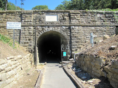
I got lucky this weekend past. I often put things on my list of possible stops along my travels and they are closed and I feel like a moron. But not so this past weekend, I took a two mile detour off 85 to visit a historic place on a day they are usually closed and I stumbled upon their ultimate celebration. I got this lucky in a cool little town a little under two hours Northwest of Atlanta on my way to Chattanooga. The town in question is the city of Tunnel Hill, Georgia and the sight I wished to encounter was their Great Tunnel


The tunnel runs 1477 feet through the Chetoogeta Mountain. It was completed in 1850 and served as the first rail tunnel through the Appalachian mountains and served to connect Augusta and the new town of Atlanta to the Tennessee Valley and up the Northern Coast. It was dedication in October of 1949 and the first train passed through on May 9, 1850. Prior to that railcars were literally portaged over the mountain. The tunnel over time became functionally small so a new tunnel was built a few hundred feet North of the original in 1928 and this one fell into disuse. The tracks were stripped out of it some years later and it was opened to the public in the year 2000.


We arrived on one of the few Sundays the Tunnel Hill Heritage Center was open. They were doing their annual Reenactment of the Battle of Tunnel Hill. We arrived near the end but the ordnance fire was loud and set a beautiful aural tone. There were all sorts of folks in period attire with a nice little market and some of the best handcrafted birch beer I ever drank. We crossed a small covered bridge on foot and made our way to the tunnel. You can now walk the 1500 feet through the old tunnel to the other side. It is a marvel of pre-civil war engineering and makes for cool shade on a hot Georgia day. It is reasonably well lit, but we sort of wished we had brought flashlights. On the other side of the tunnel there was a tremendous patch of kudzu in bloom, with a gorgeous sweet smell. You also get to tour the small railroad museum and walk very near the Clisby Austin House, a fine antebellum building.


Of keen interest here is the history. First there’s the railroad and the tunnel. Secondly, there’s the Civil War heritage. The Clisby Austin home served to house General Hood of the grey and General Sherman of the blue at different times. One of the quirkier landmarks I’ve seen is here and is the gravesite of General Hood’s Leg, which was blown off in battle. The Battle of Tunnel Hill is said to be the first skirmish of the Atlanta Campaign and the campaign was designed in the Clisby Austin home. The tunnel was also one of the targets of destruction by Andrews Raiders during what has become known as the Great Locomotive Chase, but their pursuers were too close by the time they passed through this site. Having all the confederate and union soldiers walking around really brought this history home.


The tour normally costs $5 (hours and admission). And you get to see all the sites mentioned. On the day we went, it was pretty crowded being the big reenactment day and all, but I imagine on normal days it could be quite tranquil and serene. And with its location so close to the 85 corridor, I mark Tunnel Hill as one of the best little roadside attractions I’ve encountered in Georgia, period.


Trail Essentials
Approximate Time: 1 hour
Approximate Distance: 1 mile
Features: Tunnel, Historic Building, Gravesite, Civil War history

Overall Rating: B

Scenic Quality: A
Athleticism: C
Solitude: C+
Value: A-
Parking: Free
Hours of Operation: Monday through Saturday 9am-5pm
Facilities: At Railroad Museum
Maps: None needed
County: Whitfield


Rocktown

I Wanna Rock All Night… Map
From Rocktown

I have this list of places I want to see in and around Georgia. People email me and I talk to folks (and all suggestions are very welcome). So there’s this one place a little over two hours Northwest of Atlanta, that I’ve heard a lot about and have always been meaning to go, but it has been difficult to conscript a volunteer to sojourn along with me. Because when asked what the draw is, I can only answer, “Rocks.” But as luck would have it this past July, after another voyage nearby sort of petered out due to warm weather and lack of water at the falls, I was able to get my companions to visit these “Rocks” as a fallback option. And the day was salvaged by a truly amazing visit to a place known only as Rocktown, near LaFayette, Georgia.


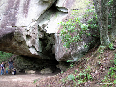
Rocktown is at the culmination of one of Several Hiking Trails on Pigeon Mountain in the Cumberland Plateau region of the state. It is probably the easiest of the bunch consisting of a very flat and very well maintained one mile walk from the parking area, even though it is at the summit of the mountain. At the end of the path, there are myriad rocks covering easily 100 acres of land. Some of the rocks are as tall as two or three story buildings. The greys and browns of the sandstone mix with the reds of the iron ore to create some visually stunning patterns. Some have odd shapes that remind one of other things like finding patterns in clouds on a lazy summer’s day.


So our easy one mile hike turned into a three hour festival of rock climbing. Now this is a true mecca for the avid rock climber and we saw a few younger folks decked out with pads and rope and the like. We had no equipment, but for a great many of the rocks none were needed. After hauling yourself up a 30 foot rock, you would be rewarded with a view of more rocks. I’ve have never been on a hike when the end of day aches focused so much on the arms and shoulders. But the pain was well worth the sense of accomplishment.


We watched a few children rush up and down the boulders, screaming with glee like it was the greatest thing ever. And some of the rocks created caves and overhangs that served as well needed shade from the hot Georgia Sun. The only caveat would be the wildlife in the area: I heard reports of bobcats but none were seen by us; our principle nemesis was the nuisance of ants when we tried to sit atop a boulder for our lunch. But this was a mild problem in comparison to the enjoyment we were able to get.


So Rocktown might be a little far away, but well worth the trip. The remoteness help keep these rocks relatively free of graffiti and vandalism. If you are looking for fun and exercise in the Northwest corner of the state, this is a great place to spend the day. It is quite understandable what all the fuss is about.


Trail Essentials
Approximate Time: 3 hours (path 1 hour-leaving plenty of time to play on the rocks)
Approximate Distance: 2 miles round trip
Features: Rocks, Vista Views

Overall Rating: A

Scenic Quality:A
Athleticism: A+
Solitude: A-
Value: A
Parking: Free
Hours of Operation: Daylight hours
Facilities: None
Maps: here (the little pink path near the center), not really needed
County: Walker

Howard Finster's Paradise Gardens

Jesus, Coca-Cola, Elvis, George Washington and More Map
“Pardise
From Howard Finster's Paradise Gardens


There’s a bunch of interesting things I’ve seen in and around this North Georgia patch of land called Atlanta, which I call home. And this website has chronicled a good number of them, 99 to be exact. With the 100th post looming on the horizon, I wanted to find the perfect place to fill this illustrious position. I agonized a bit over the subject, and was considering downplaying the whole concept. That was until I made I took a two block drive off Martha Berry Highway in Summerville (or Pennville) coming home this past 4th of July. There, just under two hours away from Atlanta, standing at the corner of Rene & Knox Streets, appropriately shining like a vision from God, was the perfect subject of my 100th post, the home of the late great folk artist Howard Finster, and his Paradise Gardens.

“The

Now, I had recently learned that the place was open to the public. Until about October of 2010, it was viewable by appointment only and the nature of my ramblings doesn’t make me especially good at meeting appointments, but presently it is open 12-4:30pm, each Saturday and Sunday. It is free to enter, but donations are accepted and greatly needed to help finance the restoration of the property. There is also a three room gallery with Art for sale, including prints which aid the preservation project.
“smaller

Beyond the Gallery lies the treasure of this visit, a truly fascinating world. Directly behind lies the two story chapel with its 8-sided cupola. The chapel is currently under renovation, and entry is not allowed to this place which was home to many free weddings and other celebrations. Behind the chapel, is the Finster home, the place where he lived and the birthplace of this beauty and craziness. The painting of George Washington on the front is said to be his first. Going back toward the gallery, there is a bridge and exterior structure, where the art is mostly crafted by Art Students who came to study with Howard. There is also a freestanding project done by Finster with Lehigh University. And then there’s a smaller chapel which you can enter, the old bike shop, the side Gardens. The Gardens looks something like a miniature golf course, if the course had no holes, clubs, or balls, and was designed by a lunatic visionary who had a fondness for decoration via any object he found with an emphasis on shiny scraps of glass and metal and a penchant for the Bible, Coca-Cola and Elvis.

“on

Overall, the place has a pervasive religious theme. The story goes that after many years as a preacher, bike repairman, and sundry other jobs, Rev. Finster caught a drop of paint on his thumb, held it to the sun, and it spoke to him, telling him to paint 5000 works of sacred art. He painted virtually non-stop from that point on, and depending on what you call a work, he amassed nearly 50000. The type of art is folk or outsider and the content is visionary and naïve, for those who understand art. They range from completely painted bicycles (this one’s at the High Museum, not here) to carved faces in concrete to simple bible verses or poems hand scrawled by the artist. A piece taken by itself might pass for graffiti, but taken as a whole mean something much greater. A polite call to Godliness from hands and brush of a true Southerner.
“bicycle

His popularity soared in the 80’s after a New Yorker bought a piece and brought it to the big city. The Gardens and Finster were the centerpiece of R.E.M’s first video, Radio Free Europe (watch here). Finster also created the award winning cover for the Talking Heads album, Little Creatures (see here). He also made an appearance on Johnny Carson’s Tonight Show (watch here), where he showed off a little country charm and his talent for song and banjo. Howard Finster passed away in 2001.
“Bike

So now there’s a need for preservation, and fortunately there seems to be an interest, but unfortunately not a cohesive one. The site is owned by Tommy Littlejohn, and he utilizes members of the Finster family to run the museum. There is support from David Leonardis, a Chicago Art Dealer and Patron, who is restoring the chapel. And there is movement by Chatooga County to purchase the place, which supposedly will help in getting donations and grants. But the last piece of the puzzle is, well, me and you, so I suggest the next time you are in the Cumberland Plateau, or if you want to see the works of one of the more important Georgia Artists first hand, you trek up there to show those with the power that this place is important to us too. And if you can help the cause financially, please do.


If you wish to donate to the restoration project you can visit the website for the email info or email them directly at revcoltom@juno.com


CNWR - Settles Bridge

Like A Bridge over Tranquil Water… Map
”Settles
From 2010-06-29 Settles Creek

OK, we should understand by now that some of the best truly local hiking can be found at the many different units of the Chattahoochee National Wildlife Refuge. So when I was perusing their site, I stumbled upon a new unit of the CNWR, which had a link for hiking maps, but no maps. This was something I had to check out. So I made my way up to the Settles Bridge Unit in Suwanee, Georgia.
”Settles

Upon arriving, I noticed that the other folks there were certainly not there for hiking. Sure, there was a young couple out for a romantic stroll by the river, but most were in swimsuits and many were carrying canoes or tubes for water fun. The trailhead sign said that the hike was a mere .5 miles, and that with significant grades to them. So we ventured forward.
”rocks

The centerpiece of the park is the remnants of Settles Bridge, an Iron & Wood framework structure built in 1896, much of it rotted away or possibly stolen. The structure does span the entirety of the river and could be crossed with considerable difficulty, and there are signs posted letting you know that that is against the law. But if you search Youtube, you will find clips of folks jumping from the bridge into the water (for example here and here). I will tell you that isn’t something I would normally do.
”path

At the bridge, we first hiked up the river downstream and couldn’t make it that far, maybe about .2 miles. We came back under the bridge and headed downstream, initially at the top of the ridgeline. The trails are rough and lightly traveled, we headed that direction for about a ¼ mile and came to a turn away from the river which ran along a small creek. At one spot there was a “T” in the road, turning right would no doubt take you back to the parking area. We headed left, did a little wet foot crossing of the stream and follow on about a half mile. My belief is that this trail is part of the trail to connect the whole CNWR and not just part of Settles Bridge itself. We turned around and made our way back this time hugging the river. There was evidence of trails across the creek going upstream, but we did not explore that area.
”Chattahoochee

Along the river, you get views of the stream, and the rocks, and the bridge. We saw a pack of canoeists coming from the North and they landed at the bridge side dock. Apparently there is some sort of boat rental place that uses the bridge as an end marker. We came within about 8 feet of a huge bird pictured below. And then we made our way along the stream back. This “trail” runs maybe a ¼ mile and is some serious tricky footing, complete with rocks and mud and climbs, but fun nonetheless.


I look forward to the completion of the Settles Bridge Trail System. Right now it is predominantly a happy swimming hole. But the serenity and peace there give me high hopes for the future of this greenspace. There is a nearby park of the same name, run by Gwinnett Parks & Recreation, which is very popular with dog lovers and skateboarders.
”the

Trail Essentials
Approximate Time: 45 min to 1 hour
Approximate Distance: .75 miles
Trail Surface: Red Clay, Compact Soil, Water Crossing, Rocks
Features: Wildlife, Bridge Ruins, Riverside Walk,

Overall Rating: B-

Scenic Quality: B
Athleticism: C+
Solitude: B-
Value: B
Parking: $3 (2010 – Standard CNWR rates)
Hours of Operation: Daylight hours
Facilities: None
Maps: None available at this time
County: Gwinnett

Cloudland Canyon

Prized State Park in the Corner of NW Georgia Map
Cloudland Canyon
From Cloudland Canyon State Park

About as far away as you can get without leaving Georgia sits a tremendously scenic state park, which I’ve been told rivals anything you have seen in the state. Because of its relatively remote location, it remains quite pristine and reasonably quiet. But the talk of the area is almost deafening. Located on the Western edge of Lookout Mountain about 2.5 hours Northwest of Atlanta stands what has been called the "Crown Jewel" of the Georgia State Park system: Cloudland Canyon State Park.
huge Rock Cave

The area was designated as a State Park in 1938 after large donations of land from private owners. The years have seen the park grow in size from 1924 acres to its present 3485. Prior to state ownership, it was known as Sitton‘s Gulch , and the prominent feature of the park is the Gulch or Canyon that serves as the centerpiece of the park. There are several areas along the ridgeline that provide majestic views of various nearby mountains and you can see well into Alabama. The gorge was carved out by Sitton’s Gulch Creek over centuries at the confluence of Daniels Creek and Bear Creek. This makes for some very pretty rock formations, both along the canyon’s walls and deposits along the canyon floor.
Waterfall One

In addition to the scenic vistas, there are two serene waterfalls at the base of the gorge on Daniels Creek. They are very cleverly named Waterfall One and Waterfall Two, falling 85 and 60 feet respectively. To be honest the waterfalls are really a series of cascades and there are numerous other opportunities to see and hear the pleasant song of tumbling water along the way.
Rock Formations

There are five separate hiking trails at the park. On the day we went, we hiked the 5 mile West Rim Loop trail and the 2 mile Waterfall trail. The water fall trail climbs about 1200 feet in and out of the canyon through a series of switchbacks enhanced with well over 600 stairs. The easier of the two falls (and prettier) takes you .1 miles down to Waterfall One. To get to Waterfall Two, you must climb part of the way out and then down .3 miles to its location. Although the water itself may be a little less impressive, the second waterfall area is much more majestic and littered with fallen rocks. The West Rim Trail takes you along the ridgeline for the full view of the gulch and the areas beyond. There is a second shorter overlook trail, a 6.5 mile trail deeper into the canyon known as Sitton’s Gulch Trail, and another backcountry trail taking you to more remote camping sites.
Waterfall Two

When something is built up as the best thing you ever saw, its very hard for the location to live up to that reputation. We have seen some amazing sights in Georgia from Amicalola Falls to the Cumberland Seashore to Providence Canyon . And I’ve never been to Stephen Foster State Park in the middle of the Okefenokee Swamp, which I’m sure is amazing. I don’t think that this is the absolute best thing the Georgia Parks system has to offer, but its clearly on the short list. But if you are looking for an affordable getaway filled with natural splendor, peace and quiet, and a solid physical challenge, this park delivers. The West Rim Loop and Waterfall trail combo is definitely one of the best hiking experiences I have had in Georgia, or anywhere for that matter.
the Clouds of CLoudland Canyon

FOR HIKING BLOGS
Trail Essentials
Approximate Time: 4 hours
Approximate Distance: 7 miles (5 mi West Ridge Trail, 2mi Waterfall trail)
Trail Surface: Rocks, Compact Soil, Stairs
Features: Great Vista & Mountain Views, Rock formations, Waterfalls
Overall Rating:
Scenic Quality: A
Athleticism: A
Solitude: A
Value: A-
Parking: Standard Ga State Park Fee ($5, June 2010)
Hours of Operation: 7am-10pm
Facilities: None on Trail, at Visitor Center, throughout park
Maps: at Visitor Center, online here
County: Dade County

Rocky Face Mountain

Graves, Gold, and little Green Men Map
George Disney's Grave
From Rocky Face

Occasionally, we all like to challenge ourselves, a couple of years ago my brother came up to Atlanta and we set out to climb several difficult mountains in North Georgia. The hike for the last day was bumped primarily due to exhaustion and I never made it back. Billed as the most strenuous short hike in NW Georgia, I simply could never get my casual hiking friends to make the trip before last weekend. The trail is called the Disney Trail and it takes you to the summit of Rocky Face Mountain, and its situated under two hours Northwest of Atlanta off I-85 just outside Dalton, Georgia .

Rocky Face Summit view
Now before I tell you about the difficulties of the trail, I want to tell you what’s so great about it. First, this climb achieves two of the three goals I have in hiking in spades. I look for exercise and this one truly gets your heart racing. I look for solitude, to get away from it all to reset my mind, and this was the first hike I’ve done where I saw no human being save my group the whole 2 ½ hours we were on it (and we set out up the trail about 1:30 pm on a Sunday). But it has more than that.

Disney Trailhead
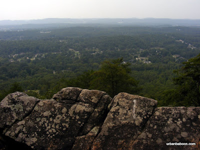
It has some very nice views from the top, which most mountains give as you can see in the pictures. We carried up our lunch and dined triumphantly at a point known as the Buzzard’s Roost. It has this one truly unique feature: a Civil war gravesite. The gravesite is of an English-born, Kentuckian who fought in the Civil War as part of a communications team by the name of George Disney . That’s why they call it the Disney trail. This was uncovered in 1912 by a group of Boy Scouts, who replaced the head stone then and who maintain the trail still to this day. Rocky Face was also the site of the Battle of Rocky Face , an early challenge to General Sherman on his campaign to Atlanta. I am always amazed to think that soldiers carried packs and artillery up mountains that I get winded on just carrying up lunch.

Disney Historical Marker (in front of Police Station)
The trailhead is clearly marked and easy to find if you know the secret. You have to turn into the First Church of the Nazarene on Hwy 41, just a few minutes off the Interstate. At the back, by the Tifton Life Center there is ample parking and to very clear signs marking the trail’s start (I imagine parking may be an issue during Church events, please be courteous). The trail starts up with a straight ascent and the incline pretty much doesn't stop for 1.2 miles. The elevation gain is better than 800 feet, which places it about 133% of the challenge that Stone Mountain presents. There are very few switchbacks, and the ones that are placed are so short to the point of being virtually meaningless. Some kind folk placed a well needed bench at about the half way point. I make no bones about it, this one is difficult, one you shouldn’t be ashamed of taking a well needed and well deserved break during your trek. And unlike Stone Mountain , you won’t have to watch a 70 year old man walk by you, making you feel inferior. The summit is about 1580 feet above sea level, not the tallest of mountains, but beautiful nonetheless.

Looking back at the Steep Trail
At the top, there is a good viewing place, known as Buzzards Roost, and directly behind that is the grave and marker for the remains of Confederate George Disney. If you walk on about ¼ more, there’s a better viewing place among the rocks on the ridge. My understanding is that the trail can be followed for a few miles (rumors say all the way to the NW GA trade center) but we didn’t go all that way. The one additional bad thing to report is that a member of my group was stung 4 times by a yellow jacket, marking our first significant injury on any of our trips. It reminds us of two things: first the importance of a good first aid kit, and second that the wilderness belongs to the nature that inhabits it.

View from Buzzard's Roost
From Rocky Face
In my research for this post, I noticed two interesting stories about Rocky Face that go beyond History. There is a rumor that there’s Gold in them hills , specifically Cherokee gold. Considering Georgia’s historical place in gold mining this could be believed but the stories talk about bars six feet long. It might be the Waterhouse Treasure , but who knows and we certainly didn’t find it. The second it that the region is watched by 3 foot tall elves, leprechauns, spirits or trolls (Read this stuff, it’s a hoot). Again I can confidently say, we met no one.

the Rocks of Rocky Face
So if you are looking to challenge yourself, see a civil war grave, search for gold, or fight off leprechauns, the Disney trail up Rocky Face mountain has something for you.

Trail Essentials
Approximate Time: 2 hours
Approximate Distance: 2.4 miles
Trail Surface: compact soil, rocks
Features: Vista Views, Gravesite, Historical Significance, Athletic Challenge
Overall Rating: A
Scenic Quality: B+
Athleticism: A+
Solitude: A+
Value: A
Parking: Free in the Tifton Family Life Center Parking Lot
Hours of Operation: Virtually Anytime
Facilities: None
Maps: None, trail well marked
County: Whitfield

Red Top Mountain

ANOTHER GREAT GEORGIA STATE PARK Map
Red Top Mountain State Park
From Red Top Mountain
The State of Georgia is blessed with many fine locations of natural beauty. And we as residents of the state are fortunate to have a State Park System committed to preserving, protecting, and facilitating our shared natural resource. Just to give an example, I’d like to tell you about a fine-looking state park about 45 minutes Northwest of Atlanta called Red Top Mountain State Park & Lodge .


Red Top mountain is home to about 11 miles of hiking on 6 separate trails. Most are shorter and very easy to do. The two longer ones are the Iron Horse Trail (which allows Bicycling) and my personal favorite and the subject of this article: the 5.5 mile Homestead Trail. Now don’t let the Mountain in the name scare you, the top elevation is merely 1060 feet and the trail is more of a nice walk around the mountain rather than any real type of uphill climb. The park's website list this excursion as moderate in difficulty, and I concur, but I think its on the lighter side of moderate. There are some ups and downs but no significant patch that should really take the wind out of you. The trail itself has very good footing mostly of compact soil, namely Georgia Red Clay, from which the place gets its name. The 5.5 miles does mean at least a two hour commitment, so its not for the very casual stroller.
Rocks & The Etowah River

The best thing about the trail is the views of the water. The park is on a peninsula created by the damming of the Etowah River, which created Lake Allatoona. The water views to the East are the River and to the West is the Lake. There are a large number of places where you can break from the trail and explore the water, even getting a little wet if you are so inclined. Along the waterside, there are also some interesting rocks on which to climb, which should make it fun for kids. The Lake itself is a very popular destination for water enthusiasts, so you might see a pretty sailboat or motorboat to enhance the view. The trail must also be very dog friendly because we encountered more than half a dozen canines along the way.
Red Top Mtn Dogs at Play

The reason I bring this up is two fold. First, this is a very nice park close to Atlanta with a good trail that fits all my required criteria: Scenic Beauty, Good Exercise, and a break from the clutter of city life. But also because I read that the State Park System is thinking of thinking about upping the parking rate for areas such as these from $3 to $5 ($30 to $50 for a season pass). And I wanted to go on the record that every time I drop my $3 in the parking slot this thought goes through my mind, "I get all this for me and my friends for $3 bucks??" I almost feel as if I’m stealing something. I know times are tough but its still a value, and if the good folks at Georgia Parks & Recreation continue to provide places like this to people like you and me, I support them 100%. If you care to exercise your rights at as a citizen, public hearing will be held on April 6 at the Floyd Towers East in Atlanta from 9am to noon (Directions).
A cove on Lake Allatoona

But back to Red Top Mountain, this is a good place to get away and unwind, to get your blood moving, and enjoy the nature of Georgia. And the fact that its relatively nearby makes it a real bargain at either price. And it gives you a nice reading on the impact of our water consumption and drought status as Allatoona is used for water supply for the surrounding areas.
Homestead Trail Path

Trail Essentials
Approximate Time: 2-3 hours
Approximate Distance: 5.5
Trail Surface: Compact Red Clay, Soil, some rocks off the path
Features: Waterside Views, Popular for trees

Overall Rating: B+
Scenic Quality: A-
Athleticism: B+
Solitude: B
Value: B+

Parking: $3 (for now)
Hours of Operation: 7am-10pm
Facilities: At the trailhead and visitor center
Maps: at the Visitor center, trail is marked, online here
County: Bartow

ShareThis

Related Posts Plugin for WordPress, Blogger...