Showing posts with label GA State Parks. Show all posts

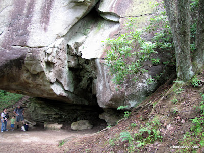
Sprewell Bluff State Park

The Flint River in Danger again map
From Sprewell Bluff


Whenever I read a story about Atlanta’s water supply and the disputes surrounding, one side note has always intrigued me. Basically, in addition to the creation of reservoirs on the Etowah, Chattahoochee, and Savannah rivers, there were plans to build a reservoir on the Flint River. But, due to its natural beauty, then Governor Jimmy Carter gave the Flint River a pardon. I know that the Flint flows through areas of Carter’s childhood, but I wanted to see what he saw. And I wanted to see it before it goes away. The best place to look is at the former proposed site of the dam, which is now Sprewell Bluff State Park, located just under 2 hours South of Atlanta, near Thomaston.
Now the other curious thing about this park is on the state web page under activities, it lists among the usual culprits, the quite unusual rock skipping. It’s not unusual to skip rocks per se, but it is unusual to list that among things to do. At Sprewell Bluff, they even have an annual rock skipping contest on Labor Day weekend. Even though I’ve said it was strange, as you stand on the bend of the river, you can’t help but think, “This is a great place to skip a rock.”

There is also a 3 mile hiking trail. it runs up and down the bluff to the river in a series of loops with out and backs at each edge. At one edge you head out to a natural dam, and at the other you pass by an overlook with a nice birds-eye view of the river and it ends at the aforementioned Rock Skipping place. It’s a nice peaceful trail with some elevation gain and loss, enough to call it decent exercise. And the river itself is beautifully tranquil. After walking the trail, we ended the day, grilling burgers at the side of the river.


So what did Jimmy see? The natural beauty of the Flint River winding its way through rocky bluffs, a great place to fish or canoe, or maybe he just sat there and skipped a rock. Any way you slice it, Sprewell Bluff State Park is peaceful getaway, I’m glad to see preserved intact. With the water problems we have, let’s hope that the idea of damming the Flint is not rekindled.

Trail Essentials
Approximate Time: 1-1.5 hours
Approximate Distance: 3 miles
Features: River Walk, Shoals, Long distance River Views

Overall Rating: A

Scenic Quality: A
Athleticism: B
Solitude: A
Value: A
Parking: Standard State Park Rates ($5 2011)
Hours of Operation: 7am - Sunset
Facilities: At Picnic Area
Maps: here
County: Upson


Hard Labor Creek State Park

2 Hours at Hard Labor map
From Hard Labor Creek

As I have said before, Georgia has a lot of really terrific state parks. Probably the least invitingly named one of these is the curiously named Hard Labor Creek State Park. Don’t let the name scare you, I’ve spent a few days within its confines and the most work I had to do was to tote a satchel. But the odd name may be one of the reasons it is so quiet, as it is bearly over an hour East of Atlanta out I-20.


The area was named before the State Park was built and either comes from one of two stories about it being difficult in that area. One legend says that Slaves worked extra hard on clearing the area as it was too rocky, the other says that Indians gave it that name due to the difficulty of crossing the creek in wet weather. Either way, the work for you has been done.


The area is probably best known for its Golf Course, but I don’t talk much about golfing. It does have two hiking trails that intersect to give you about 2.1 miles of marked hiking trail (Trail Guides) to walk through. The Trail head begins back behind the trading post off to the right of an open picnic area. The first trail is called the Beaver Pond Trail which is marked with red blazes and the second is the Lake Brantley Trail marked with Yellow blazes. Each runs about a mile but can be connected to form a 2 mile loop. You cross bridges and see boulders and move through ravines, the stuff that you’d expect. There’s enough up and down to get your heart running a little. It’s supposed to be especially good for the bird watchers and plant lovers, but that is not my strong suit, so I won’t be the judge.


I’ve marked the full trail at three miles, although the state maps end at 2.1, because no trip to the park would be complete without a thorough inspection of the lake. Upon completing the trail, cross the parking lot and you can move along the edge of the lake pretty easily, though there is no marked trail.
After a slightly wet foot crossing continue left to reach the goal of the street, here you get a nice view of the water running off the lake under Fairplay road. After crossing the street, there are some ruins of what looks like a stone toll booth and some nice moving water. You can continue up the creek about a third of a mile. If you continue around the lake, you will be adding some distance to your hike and will be moving through the campground areas.


Georgia state parks have a lot to offer, Hard Labor Creek is no exception to the rule. This park is simple, serene, and a nice way to spend a few hours. On this trip, because it is so close to Social Circle, we usually stop at the Blue Willow Inn for some food, being one of the finest Southern Eateries we know. As a matter of fact, we usually do the food first and let the pleasant time spent at Hard Labor help burn off the calories and aid digestion.


Trail Essentials
Approximate Time: 1.5 – 2 Hours
Approximate Distance: 3 miles
Features: Ravines, Lake Views, Riverside Walk, Minor Ruins
Overall Rating: B+

Scenic Quality: B
Athleticism: B
Solitude: A
Value: B+
Parking: State Park Parking Fee ($5)
Hours of Operation: 7am-10pm
Facilities: In Parking Area
Maps: none, well blazed except around the lake
County: Morgan County


Smithgall Woods

Helen’s Nature Retreat Map
From Smithgall Woods
The third most travelled to destination in Georgia is Alpine Helen. And it might be my most travelled to area because of its receptiveness to the outdoor adventurer. There are several interesting places to hike in the general vicinity. One place eluded me until this year. You see every other time I went hunting was in full force and I simply don’t chance that stuff and find other places to go. But in March of 2010, I was able to make my way into Smithgall Woods Conservation Center and enjoy some of the 23 miles of hiking and biking available to folks such as us.


Unlike most of the area’s outdoor excursions, this one is set up more like a retreat center than a wilderness area. When you enter the wooden fence, you get that feel immediately. I have already mentioned the hunting done on premises, but it is also one of the premier trout fishing destinations of North Georgia. Dukes Creek runs right through the middle of it and its pristine waters make for good fishing as well as a serene backdrop for your day in the woods. The main road, called Tsalaki Trail is paved and takes you to the 5 separate trails designed for the hiker. The trails are mostly short, ranging from .3 to 1.6 miles. We walked four of the five that day, and with the walk up and down Tsalaki, we covered just about 6 miles.


The two most interesting trails are the Ash Creek Trail and Martin’s Mine Trail. Ash Creek explores Dukes Creek and includes two wet foot crossings of the stream, so be prepared. The highlight of this trail is the water itself. Martin’s mine trail was our predetermined destination because we thought it would be neat to see gold mine shafts. There were three different shafts, one of which was filled in, that you could look down. In pictures, they look more like holes in the ground than anything fantastic, but I assure you it was a nice treat on our path. On this trail there was also a minor but quite pretty waterfall, and waterfalls always seem to deliver. The short wetlands path had a nice boardwalk and almost seemed like you weren’t in the North Georgia Mountains. The nearest trail was a simple nature trail, which was ok, and the furthest trail is the Cathy Ellis trail, which we didn’t traverse. There is no dominating mountain climb or deep valley to enter, so I would rate all these trails as very easy, with the possible exceptions of crossing the water on the Ash Creek Trail or the actual climb up to the waterfall, which aren’t difficult, but certainly aren’t simple.


Along the way there are a few other interesting sites. At the Nature Center, there’s a small museum inside and a couple of captive birds or prey outside. Along the Paved Road, you encounter a small covered bridge, called Bay’s Bridge, which was placed there as gift from husband to wife by the Smithgalls, the sites original benefactors. There was also a bee farm, so I encountered my first warning sign that read “Caution Bees.” These added nice extra diversions to our day at Smithgall.


So if you are looking for a getaway from your getaway in Helen, and want a simple but serene day in nature, Smithgall Woods fills this role admirably. Because of the relatively easy trails, I would rate this as a top family destination, and if you include the hawks, bees, and museum, kids are sure to enjoy it. If you fish, you probably already know about this place. I’d advise you call ahead about the possibility of hunting (706.878.3087), it seems the hunting dates are grouped around Helen’s busy Oktoberfest season. Because of the paved middle road, you could bring your bicycles to get from trail to trail. If you go, you ought to take the 2 mile car trip afterward to visit Dukes Creek Falls.


Trail Essentials

Approximate Time: 4 hours (all trails)
Approximate Distance: 6 miles
Features: Waterfall, Riverside views, Marshland, Old Goldmines, Covered Bridge, Wildlife, Bees.

Overall Rating: B

Scenic Quality: B+
Athleticism: B- (mostly because of distances)
Solitude: B
Value: B
Parking: Standard State Park Fee ($5, March 2010)
Hours of Operation: 8a-6p Mo Tu Th Fr 7a-6p We Sa Su
Facilities: At the visitor center
Maps: At visitor center, here
County: White


Cloudland Canyon

Prized State Park in the Corner of NW Georgia Map
Cloudland Canyon
From Cloudland Canyon State Park

About as far away as you can get without leaving Georgia sits a tremendously scenic state park, which I’ve been told rivals anything you have seen in the state. Because of its relatively remote location, it remains quite pristine and reasonably quiet. But the talk of the area is almost deafening. Located on the Western edge of Lookout Mountain about 2.5 hours Northwest of Atlanta stands what has been called the "Crown Jewel" of the Georgia State Park system: Cloudland Canyon State Park.
huge Rock Cave

The area was designated as a State Park in 1938 after large donations of land from private owners. The years have seen the park grow in size from 1924 acres to its present 3485. Prior to state ownership, it was known as Sitton‘s Gulch , and the prominent feature of the park is the Gulch or Canyon that serves as the centerpiece of the park. There are several areas along the ridgeline that provide majestic views of various nearby mountains and you can see well into Alabama. The gorge was carved out by Sitton’s Gulch Creek over centuries at the confluence of Daniels Creek and Bear Creek. This makes for some very pretty rock formations, both along the canyon’s walls and deposits along the canyon floor.
Waterfall One

In addition to the scenic vistas, there are two serene waterfalls at the base of the gorge on Daniels Creek. They are very cleverly named Waterfall One and Waterfall Two, falling 85 and 60 feet respectively. To be honest the waterfalls are really a series of cascades and there are numerous other opportunities to see and hear the pleasant song of tumbling water along the way.
Rock Formations

There are five separate hiking trails at the park. On the day we went, we hiked the 5 mile West Rim Loop trail and the 2 mile Waterfall trail. The water fall trail climbs about 1200 feet in and out of the canyon through a series of switchbacks enhanced with well over 600 stairs. The easier of the two falls (and prettier) takes you .1 miles down to Waterfall One. To get to Waterfall Two, you must climb part of the way out and then down .3 miles to its location. Although the water itself may be a little less impressive, the second waterfall area is much more majestic and littered with fallen rocks. The West Rim Trail takes you along the ridgeline for the full view of the gulch and the areas beyond. There is a second shorter overlook trail, a 6.5 mile trail deeper into the canyon known as Sitton’s Gulch Trail, and another backcountry trail taking you to more remote camping sites.
Waterfall Two

When something is built up as the best thing you ever saw, its very hard for the location to live up to that reputation. We have seen some amazing sights in Georgia from Amicalola Falls to the Cumberland Seashore to Providence Canyon . And I’ve never been to Stephen Foster State Park in the middle of the Okefenokee Swamp, which I’m sure is amazing. I don’t think that this is the absolute best thing the Georgia Parks system has to offer, but its clearly on the short list. But if you are looking for an affordable getaway filled with natural splendor, peace and quiet, and a solid physical challenge, this park delivers. The West Rim Loop and Waterfall trail combo is definitely one of the best hiking experiences I have had in Georgia, or anywhere for that matter.
the Clouds of CLoudland Canyon

FOR HIKING BLOGS
Trail Essentials
Approximate Time: 4 hours
Approximate Distance: 7 miles (5 mi West Ridge Trail, 2mi Waterfall trail)
Trail Surface: Rocks, Compact Soil, Stairs
Features: Great Vista & Mountain Views, Rock formations, Waterfalls
Overall Rating:
Scenic Quality: A
Athleticism: A
Solitude: A
Value: A-
Parking: Standard Ga State Park Fee ($5, June 2010)
Hours of Operation: 7am-10pm
Facilities: None on Trail, at Visitor Center, throughout park
Maps: at Visitor Center, online here
County: Dade County

Andersonville Civil War Prison

Hell on Earth in Pleasant Middle Georgia Map
shebangs inside blockade wall
From Andersonville
 
(Part I of a three part serious on my trip to Andersonville, Part II here, Part III here)


I’m a fan of Mr. George Santayana’s work, using one of his quotes, everyday since day one of this project on the front page. Probably, the most often quoted piece of his wisdom is “Those who cannot remember the past are doomed to repeat it.” In this light, I like to embrace the good and the bad of our collected behavior, with a slight emphasis on the bad, which we tend to want to forget or to change, so we don’t feel as “icky” about ourselves in hindsight. Earlier this year I traveled to a place that can lay claim, albeit dubiously, as one of the worst moments of our collective culture, and certainly Georgia history, and I did this at a time where more and more I hear people rooting on the mistreatment of prisoners. The irony, the history, and the sadness is palpable at the Andersonville Civil War Prison . The content of this visit is so grand that I will discuss it in three parts, even though it is easily visited in one setting). This is part one: National Prisoner of War Museum and Andersonville Prison.
staring at the blockade wall

It sits 129 miles South of Atlanta, just over two hours away near the peaceful middle Georgia towns of Americus and Plains. There is no cost to enter save the time required to arrive and visit, so I consider it a shame on me for waiting until 2010 to visit (not even a parking fee). When you arrive, you first enter the National Prisoner of War Museum with the sacred land of Andersonville placed right behind it.
a prisoner of war

The Prisoner of War museum is a fitting tribute to POW’s and perfectly placed at the foot of the infamous Civil War Prison. It truly sets the tone for what you are about to see. And no, it is not dedicated only to the Civil War POW’s. There are displays from virtually every war since. There’s amazing artifacts showing how POW’s survived from food to grooming to toilet paper. There are a couple of facsimiles of cells: one in concrete, one in Vietnam Bamboo. There’s an amazing dark room that uses lighting tricks to try to get you to understand what life might be like to live constantly with a gun in your face. There are correspondences from soldiers who tell their tales. Utilizing an hour of your time in this building will get your mind right for viewing what comes next.
the fields of Camp Sumter

When you exit behind the museum you are confronted with the place that as many as 33,000 Union Soldiers were imprisoned. The first impression is probably the same impression the Confederates who decided on the as the place for the building of a prisoner encampment: a bucolic green field with a small stream running through it. What it was to become was probably more difficult for them to imagine that the modern viewer because of our historical knowledge. On the left side is a depiction of one corner of the stockade walls. Outside the walls is a pillory; inside the walls are makeshift tents called “Shebangs” which are the type of sticks and cloth structures used by the captured soldiers to fend of the Georgia heat. Along the whole of the concourse is the stockade line and deadline: a phantom line today but if crossed at the wrong moment of history meant death by gunshot from guards placed in the towers because any attempt to approach the walls meant attempt at escape.
cannon on star fort

On the backside of the walk, there is a star fort where the commandant of the prison could survey his charges, complete with two replica cannons. There is also the land where the hospitals for the sick were kept. There is another stockade wall on the right side this one depicting entry in the prison camp. Near this stockade is a stonework temple housing Providence Spring , a gift of water to the inmates, that seemingly came from nowhere to give drink to those in desperate need of water. On the near right side is a sort of monument park, erected granite commemorating each states contribution to the internment and dead at the prison. Among these are trees that have types of tunnels built at their base showing the way a prisoner might dig to escape. There are actually a number of small granite markers throughout the site marking filled in water wells or escape tunnels depending on your viewpoint.
providence spring

The prison was a difficult place to live and a difficult place to face even in the 21st Century. Pictures of emaciated inmates seen either online or in the museum are difficult to forget. The stories of mistreatment and even prisoners roughing up other prisoners are sickening. It makes me think of my family and friends who have served this country past and present. It makes me think of John McCain. It makes me think of the stories about us at Abu Ghirab and Gitmo, but I digress.
Prisoner Monuments

I know there are a lot of causes for the starvation and sickness that ran rampant through this camp, and I won’t pass judgment. I know Captain Henry Wirz was following orders and had limited supplies. I know that the North refusing to recognized the Confederate Nation led to the end of prisoner exchange and the swelling of the ranks at the Camp. I know about the Union’s version of Andersonville at Camp Douglas in my hometown. The bigger picture is what weighs heaviest on my mind: Of what are we made that allows us to act this way toward our fellow man? Do we have the dignity and courage to rise above this flaw in our makeup and become the noble beast I think we all want to become? Is the past prologue? Do we ever learn? Does one person’s abandonment of morality give me the moral authority to do likewise? Can two wrongs actually make a right?
cross and you’re dead

The history of the place is easy to find and I will include some links (here , here , and here ), I wanted to simply give you an impression. The walk is paved and only gently graded and runs about 1.5 miles. If you can’t walk it, you can drive for most of it. I would place this historic site on the list of must see, not simply nice to see or ought to see.
back at the POW museum

Watson Mill Covered Bridge State Park

Better Know a Covered Bridge: Watson Mill  Map
Watson Mill Covered Bridge State Park
From WATSON MILL COVERED BRIDGE

Earlier this year, I traveled to see the State’s Longest Covered Bridge, which sits as the centerpiece for a very nice 1000 acre state park situated at about 2 hours West and North of Atlanta (about 45 minutes West of Athens) near Comer, Georgia. The park bears the name of the Bridge and is called Watson Mill Covered Bridge State Park.
Riverview of Watson Mill Covered Bridge

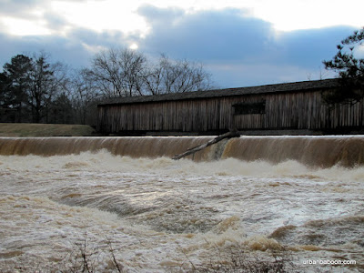
Now we came for the Bridge, a magnificent structure spanning 236 feet across the Broad River. It was built in 1885 by renowned bridge builder W.W. King in the town lattice style (A little History here ). It was built to replace an earlier bridge which washed out during one of the “freshets,” or flash flooding. I have read that the bridge is not in use, but you can drive across it and the road you are on will take you back toward Athens, so I think that information is incorrect.
Powerhouse Ruins

On the day we went, in February of 2010, we experienced one of these freshets. The water was raging under the bridge and over the dam about 15 feet away. The banks of the broad river widened greatly covering the rocks and the land trees were growing from over a much greater span than the long bridge. It’s my understanding that the area is very popular for playing on the rocks and swimming, but there would be none of that this day.
Raging Water under the Bridge

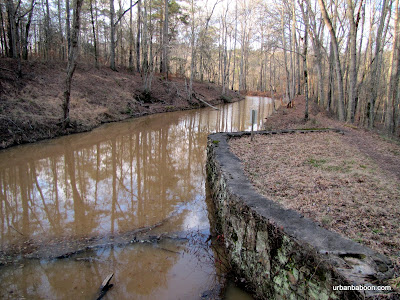
To our surprise, we found two very nice hiking trails on the both sides of the river. Both gave exceptional views of the river and bridge, but the North side was more interesting. Aside from a couple of well placed viewing platforms, they have some nice ruins of the old powerhouse. You get to walk a short two mile loop along the stream and back along the raceway (or vice versa). The South side loop runs about 2.5 miles beginning on the shores of the Broad river but then circling into the woods in what is billed as a nature trail, which could also be a fairly simple bike path.
Broad River's Raging waters

Some of the covered bridges I have visited in the past, were simply little stop bys on the way to or back from another destination. The Watson Mill Bridge and surrounding state park can stand as a destination in itself: A nice 4.5 mile walk; a pretty river and historic bridge, and the possibility of a quick dip in the river along the rocks
Along the raceway

Trail Essentials
Approximate Time: 2-2.5 hours
Approximate Distance: 4.5 miles
Trail Surface: Compact Soil, Rocks, some wooden stairs
Features: Riverside View, historic Bridge, Ruins
Overall Rating:
Scenic Quality: A
Athleticism: B
Solitude: B
Value: A
Parking: $5 (standard state park fees-2010)
Hours of Operation: Daylight hours
Facilities: At the welcome center
Maps: North side (not needed), South Side (Blazed)
County: Madison County

Panola Mountain

THE MOST NATURAL AND UNDISTURBED MONADNOCK OF EXPOSED GRANITIC ROCK IN THE PIEDMONT BIOPHYSIOGRAPHIC PROVINCE. Map

From Panola Mountain


I just love the above sentence.  I usually make up what I think are catchy little titles to my posts, but what could possibly draw a reader in better than that sentence.  To be honest, I had to look up one of the words, only because I’ve come across monadnock previously.  But apparently, we Atlantans live 30 minutes west of “the most natural and undisturbed monadnock of exposed granitic rock in the Piedmont biophysiographic province.”  And I believe its something you should know about and see, so I’m going to tell you the story of hiking Panola Mountain and Panola Mountain State Park .


Panola Mountain is a National Natural Landmark and the centerpiece of the Georgia State park of the same name.  It is a granite mountain similar to Stone Mountain or Arabia Mountain .  If Arabia Mountain is Stone Mountain’s quieter brother, Panola Mountain is the third child locked in his room to keep him from harm.  As a matter of fact, there are no public trails to its summit.  The public trails at the park are only 2 miles long and take you along the base of the mountain (there’s also a fitness trail at about a mile).  So I put this trip off for a long time because I didn’t want to drive a hour for a two mile walk (I live North of the city).   So I made my pilgrimage on the way back from another state park further East.


And I got lucky.  I had heard that they had ranger led guided tours that scale the summit, but they were always at 10 am on Saturdays, which is very difficult for me to make (I work a majority of Saturdays, thus the focus of this site on Sunday daytrips).  The plan was to stop and do the self guided trail along the base of the mountain, but they have started something new: what they call the Mountain Top Owl Prowl , which takes you on a guided trek up the mountain as the sun is setting.  Normally you have to make reservations (call 770-389-7801) and they limit the group to 25, but the nice guide Jeff expanded the group to 27 to make room for the baboon and one companion.


The reason the mountain is off limits to untrained and unescorted personnel is to keep the mountain natural and undisturbed.  It is home to many species of lichen, moss, diamorphs, and herbs that just don’t exist anyplace else.  Some are endangered, some are endemic to granite outcrops, and some are just plain rare.  So even though you are climbing to the 940 foot peak (the elevation gain is only about 250 feet), the star of the show is literally at your feet.  You walk near and, in some unfortunate cases, over a patchwork quilt of yellows, reds, greens, greys and blacks which is visually quite stunning.  But you do your best not to walk on them, if you crush them they are dead and will not be back for 800 or so years (Try growing a plant on a rock and see how long it takes).  The colors come from such species as Vigueria Porteri, Minuartia Uniflora, and the most famous red Diamorphia Smallii, just to name a few.  You will walk up single file and the guide will tell you to do your best to walk in the preceding persons footsteps, and tell you which colors are better to walk on if faced with no other choice, but I forget the order.  Eventually, there will be a path made by the added hikers, and I guess the added attention to the park will help preservation in the long run.


You will also get to see the sun set over Atlanta, which is always nice.  You may see some wildlife like deer or owls, but we did not.  The granite rock in and of itself is quite picturesque.  There are also some old cabins owned by the Yarborough Family (who previously owned the land) and a very serene little pond.  In additon to the owl crawl (1st Saturday of the month at 8pm), and the Every Saturday 10 am hike, but they have also added a Sunday hike (2nd Sunday of each month at 2pm), so the opportunity to visit has expanded to 150 people a month and accommodates folks of differing schedules.  The owl crawl is probably only 1.5 miles as you drive to a different parking area to save on time and light, but the other two go a full 3.5 miles.  There is a cost involved, the hike costs $7 and there is a $5 parking fee as all Georgia Parks have. [All fees and times are current for April 2010, check their Website ] And remember reservations are required.


I hope I didn’t scare you off with the rules and fees, because it is truly a unique experience I am very grateful for having done.  You see the most beautiful things that would make you scrunch your nose in disgust, if you saw it on a loaf of bread.  You scale another of Georgia’s great peaks.  And the money supports the great natural treasure of Panola Mountain and our great resource of Georgia’s State Parks.


Trail Essentials
Approximate Time: 1-1.5 hours (Night Owl Crawl)
Approximate Distance: 1.5 miles
Trail Surface: compact soil, granite, small life forms
Features:  rare species of flora, mountain peak, panoramic views
Overall Rating:
Scenic Quality: A+
Athleticism:  A-
Solitude: A+
Value: A
Parking: $5  
Hours of Operation: Special for hikes, see text
Facilities: At the visitor center
Maps: Guided tours none needed, at visitor center for self guided trail.
County: border of Henry and Rockdale County, near Stockbridge.

Cumberland Island

FERAL HORSES, PRISTINE BEACHES, & THE RUINS OF A CASTLE Map
“The
From Cumberland Island


Well, in my travels and talks with folk in Georgia, people often say, “you gotta go see…” I appreciate the suggestions and I take them all seriously. There seems to be one place that seems to get mentioned a lot and it has until 2010 stayed off my travels because it is beyond my self imposed limitations on this website, sitting beyond a 3 hour drive, being 5 hours away, tucked into the very Southeasternmost point of Georgia. So with this post I am creating a new category for the website entitled “A bit farther away” and starting it with a little information about Cumberland Island .
Deformed Trees

Cumberland Island is probably the most well known, the largest, and certainly the most pristine of all of Georgia’s Sea Islands. It is 17.5 miles length and its greatest width is no more than six miles, though in most places its much thinner, often less than a mile. There is no bridge to the Island and you must take Ferry over from St. Marys, Georgia or arrange for private charter. It has beautiful relatively untouched beaches, saltwater marshland, and a maritime forest with gnarled oak trees. Because the earliest Ferry leaves St Mary’s at 9 am and the latest departs the Island at 4:45 pm (Schedule and Reservations) there is really no way you could hike the 50 miles of trails in a day trip, so unless you are camping, you will probably limit yourself to walking the Southern loop, leaving out all of the North Island sights, like Plum Orchard or the First African Baptist Church . This is what we did, but don’t worry there’s still plenty to enjoy.


The Island has stayed pristine due to the lack of settlement. There have been times when there were larger groups of people on the Island. The original settlers were Timucuan Indians , then a Spanish Catholic Settlement, and later a period of plantations and slaves. But, fortunately for us, during historical periods of rapid construction, the Island was in the hands of a single family or at best a small cabal of families. The first was Nathanael Greene’s descendents just after the turn of 19th Century. The latter being the Carnegies, who amassed owner ship of about 90% of the island, starting around 1880. The high point for population came just before the Civil War, with 500 Gullah slaves working the plantations with less than 75 white settlers and overseers. Today, there are still families living there complete with homes and cars, mostly descendants from the Carnegies or those in their employ. But by agreement, upon passing of the families the land will revert to the government, creating a complete National Seashore Conservation site.
Dungeness from the front

The South end loop still has plenty to offer. There are three majors things of interest there. First, as was previously mentioned is about two miles of perfectly deserted beach. The only people you will see are the handful of campers and those that came over on the boat with you, as access is restricted to 300 people daily. The quantity of seashells, if your into that sort of thing, are unparalleled (and it’s the only thing allowed to be taken from the island). The second items of note are the wildlife and the ecology. You walk between fantastic oak, Spanish moss, and palm trees. There feral horses are the most famous animal occupants, but unfortunately we missed them (although there was ample evidence they were there). But we saw armadillos, wild turkeys, and several species of flying birds. The hiking details are listed at the end of the post.
Dungeness Castle

The final thing is the ruins of Dungeness Castle . Built by Thomas Carnegie and finished in 1886 after his death, and destroyed by fire in 1959, it is the most magnificent piece of Georgia Ruins I have seen. One can only imagine (or look at old photos) the opulence of the site in its heyday. A much smaller version of Dungeness was built by the Greene family in 1802 and the restored tabby house next door serves as a reminder of that previous era. Nearby there are ruins and some restorations of companion buildings including servants quarters, storage houses, and their activities building. There are also some very interesting rusted out automobiles and the original resting place of General Lighthorse Harry Lee (the man who proposed American Independence) though he’s been moved and we were unable to find the marker.
Rusted Cars

So I’ve been raving about this place for a few minutes now, but I would be remiss if I didn’t mention the things of which to be wary. First, you must pack a lunch and water and all necessaries as there is no way to purchase anything, save water at the ranger station. There are places in St. Marys to buy pack lunches, if you are unable to make them yourself (We got ours at the Riverfront Inn for $7 a person). Second is the cost, the ferry ride is $17, with an additional admission of $4 to the park ($2 extra bucks a night for campers - 2010 prices). If you throw in the hotel/motel stay, it is certainly not a cheap excursion. You can easily discount the cost of the boat ride as a neat event in itself. And as I have said, I was very pleased with what I spent my money on. Finally, there’s the time limitation. You can walk the 2.5 mile Southern loop in an hour, give yourself an additional hour to both play around on the beach and to frolic in the Dungeness area and you are still left with an hour till the return ferry arrives (if you take that later morning voyage). You can easily double back on some of the internal trails in search of more wildlife, as we did. But you know you can’t make it to the northern sites and back, so the trip leaves you somehow wanting less and more simultaneously.
Spanish Moss

We stayed in St. Marys, a historic event it is own right. Our hotel was the the Riverview Hotel (a bargain for a bed and breakfast type atmosphere at just North of $100 bucks a night for a room with a view). There is less expensive lodging at the Cumberland Inn and even cheaper accomodations 8 miles away in Kingsland. We ate at Captain Seagle‘s Restaurant and Saloon one evening and the Borrell Creek Landing another, but there are less expensive options up the road 5 or 6 miles. The Saloon at the Inn is great hangout for locals and visitors and I consider myself fortunate to get cussed out by the infamous Cindy Deen the Porno Queen who runs the joint.
Ferry back to St Marys

Trail Essentials
Approximate Time: 2 hours (with sightseeing)
Approximate Distance: 2.5 miles
Trail Surface: Compact Soil, Sandy Beaches
Features: Ruins, Wildlife, Ocean Views, Marshland

Overall Rating: A-

Scenic Quality: A+
Athleticism: C
Solitude: A
Value: B+
Parking: ample at the Seashore Ferry Landing and free
Hours of Operation: Closed Christmas, No Tues or Wed during the winter, Visitor Center 8:00 am to 4:30 pm
Facilities: yes, thankfully
Maps: Available at the Visitors center
County: Camden County

ShareThis

Related Posts Plugin for WordPress, Blogger...